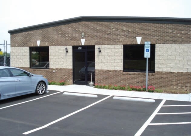
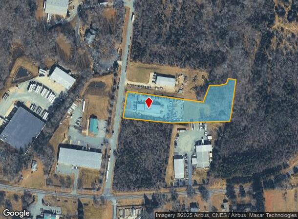
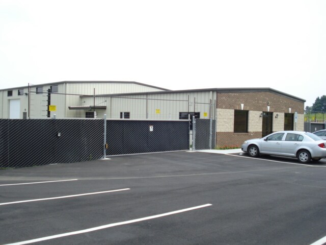
Property Record
545 Kivett Dairy Rd, Mc Leansville, NC 27301

NEARBY LISTINGS FOR SALE OR LEASE
Property Detail
545 Kivett Dairy Rd
Greensboro-High Point, NC
Rdi Properties Llc
0116780
RDI PROPERTIES LLC LO:1
Industrialgeneral
Guilford
X
North Carolina
3710880400J
1
2024
2.85 AC
2025
SE Guilford County
015302
Greensboro/Winston-Salem
7,000 SF
DEMOGRAPHICS near 545 Kivett Dairy Rd
1 Mile
3 Mile
5 Mile
2024 Total Population
540
10,689
31,203
2029 Population
532
10,597
31,087
Pop Growth 2024-2029
(1.48%)
(0.86%)
(0.37%)
Average Age
40
40
39
2024 Total Households
197
4,089
11,933
HH Growth 2024-2029
(1.52%)
(0.86%)
(0.39%)
Median Household Inc
$74,999
$77,474
$67,952
Avg Household Size
2.60
2.60
2.60
2024 Avg HH Vehicles
2.00
2.00
2.00
Median Home Value
$197,182
$205,729
$199,692
Median Year Built
1997
1995
1996
Nearby Places
Map Layers
Map Styles
 Street
 Aerial
- Restaurants
- Banks
- Shops
- Fitness
- Groceries
PUBLIC TRANSPORTATION
COMMUTER RAIL
Greensboro Station (Piedmont - North Carolina by Train (NC Train))
DRIVE
WALK
Distance
Greensboro Station (Piedmont - North Carolina by Train (NC Train))
16 min
9.6 mi
AIRPORT
Piedmont Triad International
DRIVE
WALK
Distance
Piedmont Triad International
33 min
19.9 mi
Freight Ports
Virginia Port Authority - Richmond
DRIVE
WALK
Distance
Virginia Port Authority - Richmond
219 min
190.4 mi
Nearby Properties
Address
Land Use
TOTAL SIZE
Lot Size
Zoning
Address
Land Use
TOTAL SIZE
Lot Size
Zoning
2,340,205 SF
338.69 AC
LI
Address
Land Use
TOTAL SIZE
Lot Size
Zoning
495,280 SF
105.18 AC
LI
Address
Land Use
TOTAL SIZE
Lot Size
Zoning
414,500 SF
103.57 AC
PI
Address
Land Use
TOTAL SIZE
Lot Size
Zoning
364,783 SF
30.12 AC
RM-18
Address
Land Use
TOTAL SIZE
Lot Size
Zoning
418,596 SF
23.53 AC
LI
Address
Land Use
TOTAL SIZE
Lot Size
Zoning
505,615 SF
39.50 AC
LI
Address
Land Use
TOTAL SIZE
Lot Size
Zoning
93,763 SF
33.51 AC
LI
Address
Land Use
TOTAL SIZE
Lot Size
Zoning
293,760 SF
21.94 AC
LI
Address
Land Use
TOTAL SIZE
Lot Size
Zoning
363,920 SF
34.27 AC
LI
Address
Land Use
TOTAL SIZE
Lot Size
Zoning
177,717 SF
20.81 AC
BP
Address
Land Use
TOTAL SIZE
Lot Size
Zoning
419,126 SF
33.68 AC
LI
Address
Land Use
TOTAL SIZE
Lot Size
Zoning
235,503 SF
38.75 AC
LI
Address
Land Use
TOTAL SIZE
Lot Size
Zoning
260,000 SF
20.35 AC
LI
Address
Land Use
TOTAL SIZE
Lot Size
Zoning
240,170 SF
14.01 AC
LI
Address
Land Use
TOTAL SIZE
Lot Size
Zoning
301,592 SF
19.38 AC
LI
Address
Land Use
TOTAL SIZE
Lot Size
Zoning
652,985 SF
104.62 AC
BP
Address
Land Use
TOTAL SIZE
Lot Size
Zoning
128,500 SF
14.15 AC
LI
Address
Land Use
TOTAL SIZE
Lot Size
Zoning
153,900 SF
14.23 AC
LI
Address
Land Use
TOTAL SIZE
Lot Size
Zoning
85,715 SF
15.34 AC
PUD
Address
Land Use
TOTAL SIZE
Lot Size
Zoning
146,028 SF
11.36 AC
BP
Address
Land Use
TOTAL SIZE
Lot Size
Zoning
67,872 SF
9.94 AC
GO-M
Address
Land Use
TOTAL SIZE
Lot Size
Zoning
86,400 SF
7.11 AC
BP
Address
Land Use
TOTAL SIZE
Lot Size
Zoning
57,829 SF
2.65 AC
LI
Address
Land Use
TOTAL SIZE
Lot Size
Zoning
90,000 SF
8.95 AC
LI
Address
Land Use
TOTAL SIZE
Lot Size
Zoning
37,100 SF
3.53 AC
HB
Address
Land Use
TOTAL SIZE
Lot Size
Zoning
218,126 SF
22.41 AC
LI
Address
Land Use
TOTAL SIZE
Lot Size
Zoning
109,962 SF
15 AC
LI
Address
Land Use
TOTAL SIZE
Lot Size
Zoning
58,144 SF
10.84 AC
CD-SC
Address
Land Use
TOTAL SIZE
Lot Size
Zoning
45,878 SF
1.68 AC
LI
Address
Land Use
TOTAL SIZE
Lot Size
Zoning
39,775 SF
2.28 AC
C-M
The World's #1 Commercial Real Estate Marketplace
Connect with us
© 2025 CoStar Group
The information above has been obtained from sources believed reliable. While we do not doubt its accuracy we have not verified it and make no guarantee, warranty or representation about it. It is your responsibility to independently confirm its accuracy and completeness. Any projections, opinions, assumptions, or estimates used are for example only and do not represent the current or future performance of the property. The value of this transaction to you depends on tax and other factors which should be evaluated by your tax, financial, and legal advisors. You and your advisors should conduct a careful, independent investigation of the property to determine to your satisfaction the suitability of the property for your needs.