Property Record
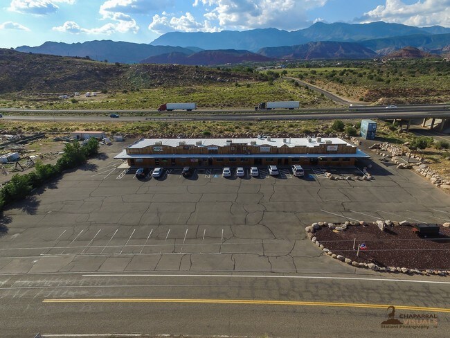
545 N Main St, Leeds, UT 84746


Property Detail
545 N Main St
0093313
S: 7 T: 41S R: 13W A PARCEL OF LAND BEING LOCATED IN THE NORTHEAST QUARTER OF SECTION 7, TOWNSHIP 41 SOUTH, RANGE 13 WEST. SALT LAKE BASE AND MERIDIAN, DESCRIBED MORE PARTICULARLY AS FOLLOWS: BEGINNING AT A POINT LOCATED NORTH 89*2457 WEST ALONG THE
Commercialnec
Washington
B and X Area of moderate flood hazard, usually the area between the limits of the 100-year and 500-year floods.
Utah
2024
3.14 AC
2025
Cedar City & St George
270101
Other Market Areas
7,200 SF
St. George, UT
NEARBY LISTINGS FOR SALE OR LEASE
-
-
View all Leeds listings for sale on LoopNet.com
DEMOGRAPHICS near 545 N Main St
1 mile
3 mile
5 mile
2025 Total Population
448
774
11,228
2030 Population
470
813
12,245
Pop Growth 2025-2030
+ 4.91%
+ 5.04%
+ 9.06%
Average Age
51
51
43
2025 Total Households
199
343
4,124
HH Growth 2025-2030
+ 5.03%
+ 5.25%
+ 9.29%
Median Household Inc
$85,500
$85,319
$75,333
Avg Household Size
2.20
2.30
2.70
2025 Avg HH Vehicles
3.00
3.00
2.00
Median Home Value
$452,439
$451,408
$470,965
Median Year Built
1993
1993
2003
Nearby Places
Map Layers
Map Styles
 Street
 Aerial
Layers
 Traffic
 Biking
Places
Listings with unknown addresses are not visible on the map
- Restaurants
- Banks
- Shops
- Fitness
- Groceries
PUBLIC TRANSPORTATION
AIRPORT
St George Regional
Drive
Walk
Distance
St George Regional
25 min
18.5 mi
Freight Ports
Port of Long Beach
Drive
Walk
Distance
Port of Long Beach
457 min
417.7 mi
SALE & LEASE HISTORY
LISTING DATE
SALE/LEASE

Aug 04, 2017
For Sale
Nearby Properties
Address
Land Use
TOTAL SIZE
Lot Size
Zoning
Address
Land Use
TOTAL SIZE
Lot Size
Zoning
5,899 SF
112.81 AC
OST20
Address
Land Use
TOTAL SIZE
Lot Size
Zoning
4,632 SF
34.11 AC
A20
Address
Land Use
TOTAL SIZE
Lot Size
Zoning
360 SF
21.58 AC
Address
Land Use
TOTAL SIZE
Lot Size
Zoning
4,832 SF
22.29 AC
OST20
Address
Land Use
TOTAL SIZE
Lot Size
Zoning
6,527 SF
20 AC
Address
Land Use
TOTAL SIZE
Lot Size
Zoning
42,000 SF
11.18 AC
RA1
Address
Land Use
TOTAL SIZE
Lot Size
Zoning
16,759 SF
0.91 AC
Address
Land Use
TOTAL SIZE
Lot Size
Zoning
5,915 SF
3.50 AC
A20
Address
Land Use
TOTAL SIZE
Lot Size
Zoning
11,024 SF
11.07 AC
OST20
Address
Land Use
TOTAL SIZE
Lot Size
Zoning
6,160 SF
5.63 AC
Address
Land Use
TOTAL SIZE
Lot Size
Zoning
3,600 SF
37.58 AC
A20
Address
Land Use
TOTAL SIZE
Lot Size
Zoning
14,807 SF
3.64 AC
Address
Land Use
TOTAL SIZE
Lot Size
Zoning
3,681 SF
3.36 AC
Address
Land Use
TOTAL SIZE
Lot Size
Zoning
1,843 SF
20 AC
OST20
Address
Land Use
TOTAL SIZE
Lot Size
Zoning
1,488 SF
17.57 AC
Address
Land Use
TOTAL SIZE
Lot Size
Zoning
3,883 SF
23.50 AC
A20
Address
Land Use
TOTAL SIZE
Lot Size
Zoning
4,456 SF
4.92 AC
A5
Address
Land Use
TOTAL SIZE
Lot Size
Zoning
5,746 SF
1.94 AC
Address
Land Use
TOTAL SIZE
Lot Size
Zoning
2,826 SF
9.07 AC
OST20
Address
Land Use
TOTAL SIZE
Lot Size
Zoning
2,981 SF
3 AC
Address
Land Use
TOTAL SIZE
Lot Size
Zoning
2,567 SF
2.56 AC
Address
Land Use
TOTAL SIZE
Lot Size
Zoning
1,983 SF
6.31 AC
A20
Address
Land Use
TOTAL SIZE
Lot Size
Zoning
2,442 SF
6.55 AC
Address
Land Use
TOTAL SIZE
Lot Size
Zoning
3,500 SF
23.90 AC
A20
Address
Land Use
TOTAL SIZE
Lot Size
Zoning
2,580 SF
8.23 AC
RE40
The World's #1 Commercial Real Estate Marketplace
Connect with us
© 2026 CoStar Group
The information above has been obtained from sources believed reliable. While we do not doubt its accuracy we have not verified it and make no guarantee, warranty or representation about it. It is your responsibility to independently confirm its accuracy and completeness. Any projections, opinions, assumptions, or estimates used are for example only and do not represent the current or future performance of the property. The value of this transaction to you depends on tax and other factors which should be evaluated by your tax, financial, and legal advisors. You and your advisors should conduct a careful, independent investigation of the property to determine to your satisfaction the suitability of the property for your needs.