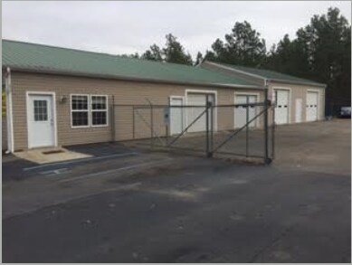
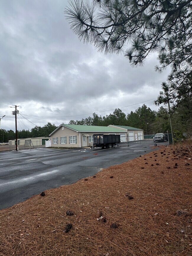
Property Record
545 N Walnut St, Pinebluff, NC 28373


Save to a Folder
{{folder.Name}}
{{folder.ListingIds.length}} Properties
{{folder.ListingIds.length}} Property
Create a New Folder
Property Detail
545 N Walnut St
8469-09-07-1069
LAMP LOT 61-64 ALS ADVLTAX N WALNUT
Autorepair
Moore
GB
North Carolina
B and X Area of moderate flood hazard, usually the area between the limits of the 100-year and 500-year floods.
61-64
2025
0.46 AC
2025
North Carolina Southeast Area
951200
Other Market Areas
3,416 SF
Pinehurst-Southern Pines, NC
NEARBY LISTINGS FOR SALE OR LEASE
-
-
View all Pinebluff listings for lease on LoopNet.com
DEMOGRAPHICS near 545 N Walnut St
1 mile
3 mile
5 mile
2025 Total Population
2,063
8,827
24,843
2030 Population
2,162
9,355
26,292
Pop Growth 2025-2030
+ 4.80%
+ 5.98%
+ 5.83%
Average Age
39
39
43
2025 Total Households
818
3,516
10,663
HH Growth 2025-2030
+ 4.89%
+ 6.14%
+ 6.00%
Median Household Inc
$71,049
$75,247
$76,837
Avg Household Size
2.50
2.40
2.30
2025 Avg HH Vehicles
2.00
2.00
2.00
Median Home Value
$231,135
$267,958
$371,683
Median Year Built
1990
1994
1992
Nearby Places
Map Layers
Map Styles
 Street
 Aerial
Layers
 Traffic
 Biking
Places
Listings with unknown addresses are not visible on the map
- Restaurants
- Banks
- Shops
- Fitness
- Groceries
PUBLIC TRANSPORTATION
COMMUTER RAIL
Drive
Walk
Distance
10 min
6.6 mi
AIRPORT
Fayetteville Regional/Grannis Field
Drive
Walk
Distance
Fayetteville Regional/Grannis Field
60 min
40.4 mi
SALE & LEASE HISTORY
LISTING DATE
SALE/LEASE

Jan 20, 2017
For Sale
Feb 11, 2024
For Lease
Dec 13, 2016
For Sale
Nearby Properties
Address
Land Use
TOTAL SIZE
Lot Size
Zoning
Address
Land Use
TOTAL SIZE
Lot Size
Zoning
15,920 SF
18.06 AC
MULTI
Address
Land Use
TOTAL SIZE
Lot Size
Zoning
9,790 SF
40.16 AC
CI
Address
Land Use
TOTAL SIZE
Lot Size
Zoning
6,900 SF
21.62 AC
CI
Address
Land Use
TOTAL SIZE
Lot Size
Zoning
5,360 SF
67.09 AC
Address
Land Use
TOTAL SIZE
Lot Size
Zoning
1,680 SF
4.22 AC
Address
Land Use
TOTAL SIZE
Lot Size
Zoning
4,966 SF
215.74 AC
R20
Address
Land Use
TOTAL SIZE
Lot Size
Zoning
2,157 SF
6.79 AC
Address
Land Use
TOTAL SIZE
Lot Size
Zoning
86.15 AC
R20
Address
Land Use
TOTAL SIZE
Lot Size
Zoning
113,540 SF
45.70 AC
MULTI
Address
Land Use
TOTAL SIZE
Lot Size
Zoning
7,465 SF
8.19 AC
R20
Address
Land Use
TOTAL SIZE
Lot Size
Zoning
4,800 SF
5.96 AC
R20
Address
Land Use
TOTAL SIZE
Lot Size
Zoning
8,870 SF
4.16 AC
Address
Land Use
TOTAL SIZE
Lot Size
Zoning
1,209 SF
5.49 AC
Address
Land Use
TOTAL SIZE
Lot Size
Zoning
40.11 AC
R20
Address
Land Use
TOTAL SIZE
Lot Size
Zoning
1,260 SF
1.51 AC
R10
Address
Land Use
TOTAL SIZE
Lot Size
Zoning
318.49 AC
RA
Address
Land Use
TOTAL SIZE
Lot Size
Zoning
2,160 SF
1.95 AC
R10
Address
Land Use
TOTAL SIZE
Lot Size
Zoning
41.93 AC
MULTI
Address
Land Use
TOTAL SIZE
Lot Size
Zoning
26,300 SF
2.50 AC
Address
Land Use
TOTAL SIZE
Lot Size
Zoning
30,000 SF
1 AC
CI
Address
Land Use
TOTAL SIZE
Lot Size
Zoning
11,280 SF
6.91 AC
R6
Address
Land Use
TOTAL SIZE
Lot Size
Zoning
30,495 SF
4.29 AC
HC
Address
Land Use
TOTAL SIZE
Lot Size
Zoning
9.84 AC
GB
Address
Land Use
TOTAL SIZE
Lot Size
Zoning
2,064 SF
2.92 AC
R20
Address
Land Use
TOTAL SIZE
Lot Size
Zoning
20,000 SF
9.89 AC
I2
Address
Land Use
TOTAL SIZE
Lot Size
Zoning
5.38 AC
Address
Land Use
TOTAL SIZE
Lot Size
Zoning
45,096 SF
10.34 AC
MULTI
Address
Land Use
TOTAL SIZE
Lot Size
Zoning
7,112 SF
1.70 AC
MULTI
Address
Land Use
TOTAL SIZE
Lot Size
Zoning
2.01 AC
HC
Address
Land Use
TOTAL SIZE
Lot Size
Zoning
17,359 SF
0.82 AC
R15
The World's #1 Commercial Real Estate Marketplace
Connect with us
© 2026 CoStar Group
The information above has been obtained from sources believed reliable. While we do not doubt its accuracy we have not verified it and make no guarantee, warranty or representation about it. It is your responsibility to independently confirm its accuracy and completeness. Any projections, opinions, assumptions, or estimates used are for example only and do not represent the current or future performance of the property. The value of this transaction to you depends on tax and other factors which should be evaluated by your tax, financial, and legal advisors. You and your advisors should conduct a careful, independent investigation of the property to determine to your satisfaction the suitability of the property for your needs.