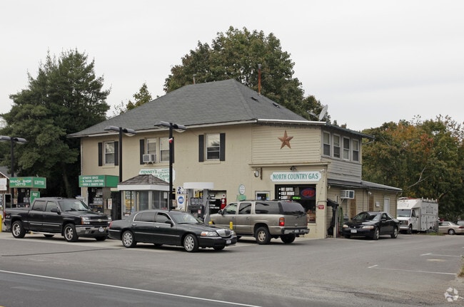
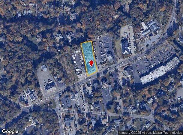
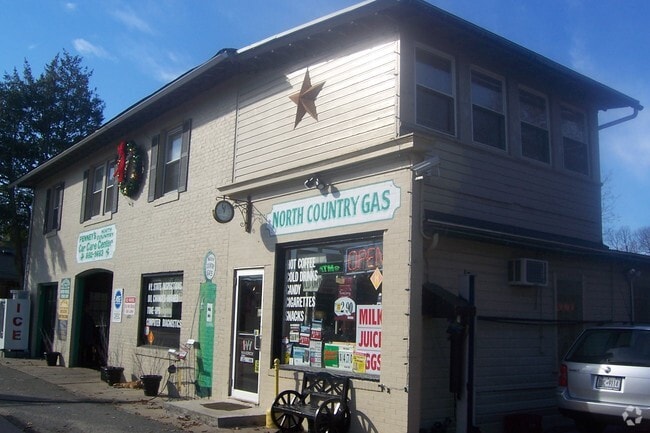
Property Record
545 Route 25A, Saint James, NY 11780

NEARBY LISTINGS FOR SALE OR LEASE
Property Detail
545 Route 25A
Nassau County-Suffolk County, NY
1-50826 TC-76 PICKUT 3HBERRY N CTRY RD OBERRY
0800-037-00-03-00-013-000
Suffolk
Commercialnec
New York
X
13
36103C0368H
1.03 AC
2024
Central Suffolk
2024
Long Island (New York)
135005
DEMOGRAPHICS near 545 Route 25A
1 Mile
3 Mile
5 Mile
2024 Total Population
6,649
53,315
161,756
2029 Population
6,647
52,709
159,332
Pop Growth 2024-2029
(0.03%)
(1.14%)
(1.50%)
Average Age
43
41
41
2024 Total Households
2,102
16,060
51,123
HH Growth 2024-2029
(0.29%)
(1.38%)
(1.81%)
Median Household Inc
$163,507
$142,441
$134,217
Avg Household Size
2.90
2.80
2.80
2024 Avg HH Vehicles
2.00
2.00
2.00
Median Home Value
$684,079
$636,938
$560,331
Median Year Built
1971
1969
1968
Nearby Places
- Restaurants
- Banks
- Shops
- Fitness
- Groceries
PUBLIC TRANSPORTATION
TRANSIT/SUBWAY
St James Station (Port Jefferson Branch - Long Island Rail Road)
DRIVE
WALK
Distance
St James Station (Port Jefferson Branch - Long Island Rail Road)
1 min
9 min
0.5 mi
COMMUTER RAIL
St James Station (Port Jefferson Branch - Long Island Rail Road)
DRIVE
WALK
Distance
St James Station (Port Jefferson Branch - Long Island Rail Road)
1 min
9 min
0.5 mi
Smithtown Station (Port Jefferson Branch - Long Island Rail Road)
DRIVE
WALK
Distance
Smithtown Station (Port Jefferson Branch - Long Island Rail Road)
7 min
3.7 mi
AIRPORT
Long Island MacArthur
DRIVE
WALK
Distance
Long Island MacArthur
22 min
9.1 mi
Tweed/New Haven
DRIVE
WALK
Distance
Tweed/New Haven
127 min
47.2 mi
Nearby Properties
Address
Land Use
TOTAL SIZE
Lot Size
Zoning
Address
Land Use
TOTAL SIZE
Lot Size
Zoning
Address
Land Use
TOTAL SIZE
Lot Size
Zoning
200 AC
Address
Land Use
TOTAL SIZE
Lot Size
Zoning
Address
Land Use
TOTAL SIZE
Lot Size
Zoning
16.30 AC
Address
Land Use
TOTAL SIZE
Lot Size
Zoning
1.55 AC
Address
Land Use
TOTAL SIZE
Lot Size
Zoning
39.56 AC
Address
Land Use
TOTAL SIZE
Lot Size
Zoning
18.20 AC
Address
Land Use
TOTAL SIZE
Lot Size
Zoning
36.82 AC
Address
Land Use
TOTAL SIZE
Lot Size
Zoning
Address
Land Use
TOTAL SIZE
Lot Size
Zoning
71.46 AC
Address
Land Use
TOTAL SIZE
Lot Size
Zoning
Address
Land Use
TOTAL SIZE
Lot Size
Zoning
64.80 AC
Address
Land Use
TOTAL SIZE
Lot Size
Zoning
20.04 AC
Address
Land Use
TOTAL SIZE
Lot Size
Zoning
9.30 AC
Address
Land Use
TOTAL SIZE
Lot Size
Zoning
38.30 AC
Address
Land Use
TOTAL SIZE
Lot Size
Zoning
18.57 AC
Address
Land Use
TOTAL SIZE
Lot Size
Zoning
Address
Land Use
TOTAL SIZE
Lot Size
Zoning
15.37 AC
Address
Land Use
TOTAL SIZE
Lot Size
Zoning
Address
Land Use
TOTAL SIZE
Lot Size
Zoning
13.90 AC
Address
Land Use
TOTAL SIZE
Lot Size
Zoning
Address
Land Use
TOTAL SIZE
Lot Size
Zoning
10.90 AC
Address
Land Use
TOTAL SIZE
Lot Size
Zoning
1.09 AC
CR40
Address
Land Use
TOTAL SIZE
Lot Size
Zoning
11.62 AC
Address
Land Use
TOTAL SIZE
Lot Size
Zoning
5.80 AC
Address
Land Use
TOTAL SIZE
Lot Size
Zoning
6.70 AC
Address
Land Use
TOTAL SIZE
Lot Size
Zoning
8.50 AC
Address
Land Use
TOTAL SIZE
Lot Size
Zoning
5.30 AC
Address
Land Use
TOTAL SIZE
Lot Size
Zoning
927.10 AC
The World's #1 Commercial Real Estate Marketplace
Connect with us
© 2025 CoStar Group
The information above has been obtained from sources believed reliable. While we do not doubt its accuracy we have not verified it and make no guarantee, warranty or representation about it. It is your responsibility to independently confirm its accuracy and completeness. Any projections, opinions, assumptions, or estimates used are for example only and do not represent the current or future performance of the property. The value of this transaction to you depends on tax and other factors which should be evaluated by your tax, financial, and legal advisors. You and your advisors should conduct a careful, independent investigation of the property to determine to your satisfaction the suitability of the property for your needs.