Property Record
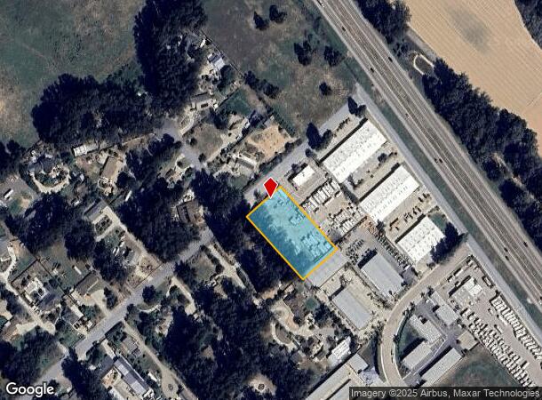
545 Sandydale Dr, Nipomo, CA 93444
NEARBY LISTINGS FOR SALE OR LEASE
Property Detail
545 Sandydale Dr
San Luis Obispo-Paso Robles-Arroyo Grande, CA
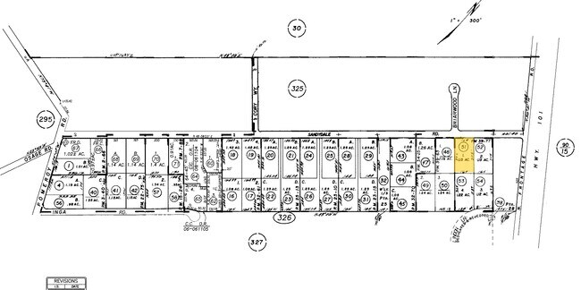
Parcel Map No Co 84 270
091-326-051
PM 39-77 PAR 1
Commercialacreage
San Luis Obispo
X
California
06079C1636G
1.15 AC
2024
South 101 Corridor
2025
San Luis Obispo/Paso Robles
012404
DEMOGRAPHICS near 545 Sandydale Dr
1 Mile
3 Mile
5 Mile
2024 Total Population
3,680
18,350
26,928
2029 Population
3,606
17,908
26,363
Pop Growth 2024-2029
(2.01%)
(2.41%)
(2.10%)
Average Age
40
41
42
2024 Total Households
1,271
6,299
9,189
HH Growth 2024-2029
(2.20%)
(2.59%)
(2.20%)
Median Household Inc
$86,204
$90,209
$102,879
Avg Household Size
2.70
2.80
2.80
2024 Avg HH Vehicles
2.00
2.00
2.00
Median Home Value
$623,333
$711,196
$729,419
Median Year Built
1985
1987
1993
Nearby Places
Map Layers
Map Styles
 Street
 Aerial
- Restaurants
- Banks
- Shops
- Fitness
- Groceries
PUBLIC TRANSPORTATION
AIRPORT
San Luis County Regional
DRIVE
WALK
Distance
San Luis County Regional
31 min
19.2 mi
Freight Ports
The Port of Hueneme
DRIVE
WALK
Distance
The Port of Hueneme
145 min
110.3 mi
Nearby Properties
Address
Land Use
TOTAL SIZE
Lot Size
Zoning
Address
Land Use
TOTAL SIZE
Lot Size
Zoning
81,330 SF
4.15 AC
CR
Address
Land Use
TOTAL SIZE
Lot Size
Zoning
2.61 AC
RMF
Address
Land Use
TOTAL SIZE
Lot Size
Zoning
4.50 AC
RMF
Address
Land Use
TOTAL SIZE
Lot Size
Zoning
728 SF
4.50 AC
PF
Address
Land Use
TOTAL SIZE
Lot Size
Zoning
3.11 AC
RMF
Address
Land Use
TOTAL SIZE
Lot Size
Zoning
34.30 AC
RR
Address
Land Use
TOTAL SIZE
Lot Size
Zoning
4 AC
RMF
Address
Land Use
TOTAL SIZE
Lot Size
Zoning
Address
Land Use
TOTAL SIZE
Lot Size
Zoning
276.22 AC
Address
Land Use
TOTAL SIZE
Lot Size
Zoning
41,631 SF
4.45 AC
CR
Address
Land Use
TOTAL SIZE
Lot Size
Zoning
20,118 SF
2.11 AC
CR
Address
Land Use
TOTAL SIZE
Lot Size
Zoning
18,065 SF
1.01 AC
CR
Address
Land Use
TOTAL SIZE
Lot Size
Zoning
39,348 SF
3.53 AC
CS
Address
Land Use
TOTAL SIZE
Lot Size
Zoning
39.09 AC
RR
Address
Land Use
TOTAL SIZE
Lot Size
Zoning
57,000 SF
3.16 AC
CS
Address
Land Use
TOTAL SIZE
Lot Size
Zoning
16,140 SF
1.36 AC
CS
Address
Land Use
TOTAL SIZE
Lot Size
Zoning
16,640 SF
1.92 AC
CR
Address
Land Use
TOTAL SIZE
Lot Size
Zoning
1.26 AC
RMF
Address
Land Use
TOTAL SIZE
Lot Size
Zoning
35,680 SF
3.86 AC
CR
Address
Land Use
TOTAL SIZE
Lot Size
Zoning
5.22 AC
CR
Address
Land Use
TOTAL SIZE
Lot Size
Zoning
20,652 SF
1.91 AC
CR
Address
Land Use
TOTAL SIZE
Lot Size
Zoning
24,057 SF
1.85 AC
CS
Address
Land Use
TOTAL SIZE
Lot Size
Zoning
4,898 SF
210 AC
AG
Address
Land Use
TOTAL SIZE
Lot Size
Zoning
16.02 AC
CS
Address
Land Use
TOTAL SIZE
Lot Size
Zoning
21,400 SF
2 AC
CR
Address
Land Use
TOTAL SIZE
Lot Size
Zoning
22,082 SF
1.33 AC
RMF
Address
Land Use
TOTAL SIZE
Lot Size
Zoning
2,049 SF
114 AC
AG
Address
Land Use
TOTAL SIZE
Lot Size
Zoning
122.84 AC
AG
Address
Land Use
TOTAL SIZE
Lot Size
Zoning
7,708 SF
0.64 AC
CR
Address
Land Use
TOTAL SIZE
Lot Size
Zoning
11,245 SF
2.83 AC
CR
The World's #1 Commercial Real Estate Marketplace
Connect with us
© 2026 CoStar Group
The information above has been obtained from sources believed reliable. While we do not doubt its accuracy we have not verified it and make no guarantee, warranty or representation about it. It is your responsibility to independently confirm its accuracy and completeness. Any projections, opinions, assumptions, or estimates used are for example only and do not represent the current or future performance of the property. The value of this transaction to you depends on tax and other factors which should be evaluated by your tax, financial, and legal advisors. You and your advisors should conduct a careful, independent investigation of the property to determine to your satisfaction the suitability of the property for your needs.