Property Record
525 W Main St, Molalla, OR 97038
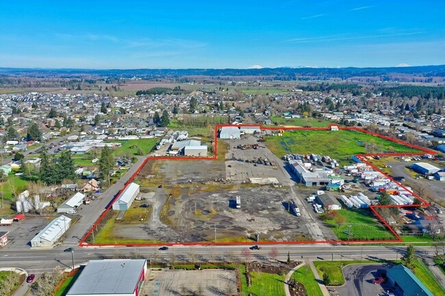
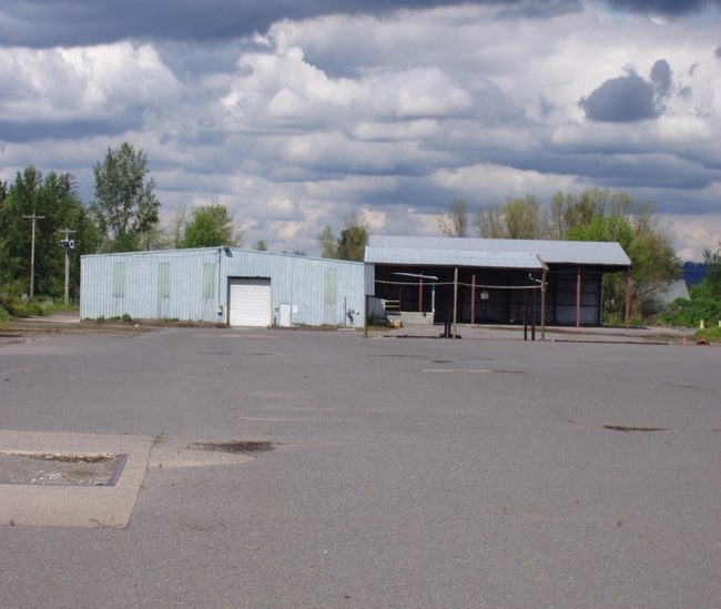
This Property Is For Sale
Current Lease Availabilities
Property Detail
525 W Main St
Portland-Vancouver-Hillsboro, OR-WA
369 THE SHAVER SUB PT LTS 1-5 8&9 LTS 10&11 BLK 10 & VAC ST
01090269
CLACKAMAS
Industrialgeneral
Oregon
M1
1-5
B and X Area of moderate flood hazard, usually the area between the limits of the 100-year and 500-year floods.
2 AC
2025
SE Outlying
2025
Portland
023901
NEARBY LISTINGS FOR SALE OR LEASE
DEMOGRAPHICS near 525 W Main St
1 mile
3 mile
5 mile
2025 Total Population
9,964
12,903
17,017
2030 Population
10,027
12,945
16,933
Pop Growth 2025-2030
+ 0.63%
+ 0.33%
(0.49%)
Average Age
38
38
40
2025 Total Households
3,477
4,526
5,991
HH Growth 2025-2030
+ 0.55%
+ 0.24%
(0.57%)
Median Household Inc
$89,685
$91,613
$94,897
Avg Household Size
2.80
2.80
2.80
2025 Avg HH Vehicles
2.00
2.00
2.00
Median Home Value
$437,994
$450,795
$488,867
Median Year Built
1993
1991
1988
Nearby Places
Map Layers
Map Styles
 Street
 Aerial
Transit
 Traffic
 Biking
Places
Listings with unknown addresses are not visible on the map
- Restaurants
- Banks
- Shops
- Fitness
- Groceries
PUBLIC TRANSPORTATION
AIRPORT
Portland International
Drive
Walk
Distance
Portland International
52 min
34.7 mi
Nearby Properties
Address
Land Use
TOTAL SIZE
Lot Size
Zoning
Address
Land Use
TOTAL SIZE
Lot Size
Zoning
13 AC
C2
Address
Land Use
TOTAL SIZE
Lot Size
Zoning
Address
Land Use
TOTAL SIZE
Lot Size
Zoning
2,134 SF
4.43 AC
R3
Address
Land Use
TOTAL SIZE
Lot Size
Zoning
151.77 AC
RI
Address
Land Use
TOTAL SIZE
Lot Size
Zoning
3,624 SF
2.95 AC
R3
Address
Land Use
TOTAL SIZE
Lot Size
Zoning
1,492 SF
4.11 AC
R3
Address
Land Use
TOTAL SIZE
Lot Size
Zoning
1,956 SF
5.75 AC
R3
Address
Land Use
TOTAL SIZE
Lot Size
Zoning
4 AC
R3
Address
Land Use
TOTAL SIZE
Lot Size
Zoning
1.59 AC
C1
Address
Land Use
TOTAL SIZE
Lot Size
Zoning
Address
Land Use
TOTAL SIZE
Lot Size
Zoning
25.76 AC
M2
Address
Land Use
TOTAL SIZE
Lot Size
Zoning
Address
Land Use
TOTAL SIZE
Lot Size
Zoning
2 AC
C1
Address
Land Use
TOTAL SIZE
Lot Size
Zoning
1,578 SF
3.92 AC
C2
Address
Land Use
TOTAL SIZE
Lot Size
Zoning
Address
Land Use
TOTAL SIZE
Lot Size
Zoning
3.65 AC
R3
Address
Land Use
TOTAL SIZE
Lot Size
Zoning
2.60 AC
C2
Address
Land Use
TOTAL SIZE
Lot Size
Zoning
1 SF
8 AC
M1
Address
Land Use
TOTAL SIZE
Lot Size
Zoning
Address
Land Use
TOTAL SIZE
Lot Size
Zoning
15.78 AC
RRFF5
Address
Land Use
TOTAL SIZE
Lot Size
Zoning
1,600 SF
1.70 AC
M2
Address
Land Use
TOTAL SIZE
Lot Size
Zoning
3 AC
C1
Address
Land Use
TOTAL SIZE
Lot Size
Zoning
3.73 AC
M2
Address
Land Use
TOTAL SIZE
Lot Size
Zoning
1,155 SF
1.14 AC
C2
Address
Land Use
TOTAL SIZE
Lot Size
Zoning
2.50 AC
R3
Address
Land Use
TOTAL SIZE
Lot Size
Zoning
9.13 AC
M2
Address
Land Use
TOTAL SIZE
Lot Size
Zoning
2.76 AC
M1
Address
Land Use
TOTAL SIZE
Lot Size
Zoning
1,266 SF
4 AC
R3
The World's #1 Commercial Real Estate Marketplace
Connect with us
© 2026 CoStar Group
The information above has been obtained from sources believed reliable. While we do not doubt its accuracy we have not verified it and make no guarantee, warranty or representation about it. It is your responsibility to independently confirm its accuracy and completeness. Any projections, opinions, assumptions, or estimates used are for example only and do not represent the current or future performance of the property. The value of this transaction to you depends on tax and other factors which should be evaluated by your tax, financial, and legal advisors. You and your advisors should conduct a careful, independent investigation of the property to determine to your satisfaction the suitability of the property for your needs.