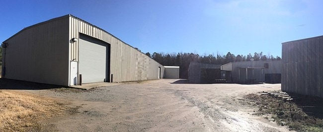
Property Record
5450 Bluff Rd, Columbia, SC 29209

Property Detail
5450 Bluff Rd
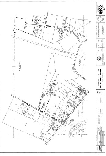
18800-02-37
PARCEL A 278X76.2X260.3X321.3X364.8 #SU #PR Z-2838 RB2178-3916
Commercialnec
RICHLAND
M-1
South Carolina
B and X Area of moderate flood hazard, usually the area between the limits of the 100-year and 500-year floods.
2.47 AC
2025
Southeast Columbia
2025
Columbia
011608
Columbia, SC
26,606 SF
NEARBY LISTINGS FOR SALE OR LEASE
-
-
View all Columbia listings for lease on LoopNet.com
DEMOGRAPHICS near 5450 Bluff Rd
1 mile
3 mile
5 mile
2025 Total Population
180
2,740
29,082
2030 Population
188
2,840
30,217
Pop Growth 2025-2030
+ 4.44%
+ 3.65%
+ 3.90%
Average Age
43
42
39
2025 Total Households
77
872
12,065
HH Growth 2025-2030
+ 5.19%
+ 4.24%
+ 4.05%
Median Household Inc
$34,999
$53,654
$58,048
Avg Household Size
2.30
2.30
2.30
2025 Avg HH Vehicles
2.00
2.00
2.00
Median Home Value
$223,333
$166,593
$196,400
Median Year Built
1977
1974
1987
Nearby Places
Map Layers
Map Styles
 Street
 Aerial
Layers
 Traffic
 Biking
Places
Listings with unknown addresses are not visible on the map
- Restaurants
- Banks
- Shops
- Fitness
- Groceries
PUBLIC TRANSPORTATION
AIRPORT
Columbia Metro
Drive
Walk
Distance
Columbia Metro
30 min
16.8 mi
SALE & LEASE HISTORY
LISTING DATE
SALE/LEASE

Sep 24, 2016
For Sale
Nov 14, 2016
For Lease
Nearby Properties
Address
Land Use
TOTAL SIZE
Lot Size
Zoning
Address
Land Use
TOTAL SIZE
Lot Size
Zoning
460,078 SF
42.80 AC
M-1
Address
Land Use
TOTAL SIZE
Lot Size
Zoning
68,012 SF
13.18 AC
M-1
Address
Land Use
TOTAL SIZE
Lot Size
Zoning
180,828 SF
17.24 AC
RSF-3
Address
Land Use
TOTAL SIZE
Lot Size
Zoning
102.68 AC
M-1
Address
Land Use
TOTAL SIZE
Lot Size
Zoning
91.51 AC
M-1
Address
Land Use
TOTAL SIZE
Lot Size
Zoning
125,976 SF
28.95 AC
M-1
Address
Land Use
TOTAL SIZE
Lot Size
Zoning
121,234 SF
6.98 AC
M-1
Address
Land Use
TOTAL SIZE
Lot Size
Zoning
144.39 AC
HI
Address
Land Use
TOTAL SIZE
Lot Size
Zoning
140.60 AC
M-1
Address
Land Use
TOTAL SIZE
Lot Size
Zoning
44,693 SF
13.92 AC
M-1
Address
Land Use
TOTAL SIZE
Lot Size
Zoning
150.94 AC
RU
Address
Land Use
TOTAL SIZE
Lot Size
Zoning
1,399.70 AC
RU
Address
Land Use
TOTAL SIZE
Lot Size
Zoning
4,800 SF
63.62 AC
HI
Address
Land Use
TOTAL SIZE
Lot Size
Zoning
102.54 AC
RU
Address
Land Use
TOTAL SIZE
Lot Size
Zoning
40,000 SF
6 AC
M-1
Address
Land Use
TOTAL SIZE
Lot Size
Zoning
37,160 SF
7.70 AC
M-1
Address
Land Use
TOTAL SIZE
Lot Size
Zoning
14,398 SF
73.50 AC
RU
Address
Land Use
TOTAL SIZE
Lot Size
Zoning
48,301 SF
4.17 AC
M-1
Address
Land Use
TOTAL SIZE
Lot Size
Zoning
3,924 SF
12.41 AC
RU
Address
Land Use
TOTAL SIZE
Lot Size
Zoning
2,265 SF
43.87 AC
GC
Address
Land Use
TOTAL SIZE
Lot Size
Zoning
64,665 SF
4.82 AC
M-1
Address
Land Use
TOTAL SIZE
Lot Size
Zoning
34.55 AC
M-1
Address
Land Use
TOTAL SIZE
Lot Size
Zoning
10,000 SF
3.67 AC
M-1
Address
Land Use
TOTAL SIZE
Lot Size
Zoning
27,440 SF
4.29 AC
M-1
Address
Land Use
TOTAL SIZE
Lot Size
Zoning
6,000 SF
4.99 AC
M-1
Address
Land Use
TOTAL SIZE
Lot Size
Zoning
8,208 SF
30.10 AC
M-1
Address
Land Use
TOTAL SIZE
Lot Size
Zoning
50.94 AC
M-1
Address
Land Use
TOTAL SIZE
Lot Size
Zoning
28.91 AC
M-1
Address
Land Use
TOTAL SIZE
Lot Size
Zoning
39.93 AC
M-1
Address
Land Use
TOTAL SIZE
Lot Size
Zoning
8,208 SF
12 AC
M-1
The World's #1 Commercial Real Estate Marketplace
Connect with us
© 2026 CoStar Group
The information above has been obtained from sources believed reliable. While we do not doubt its accuracy we have not verified it and make no guarantee, warranty or representation about it. It is your responsibility to independently confirm its accuracy and completeness. Any projections, opinions, assumptions, or estimates used are for example only and do not represent the current or future performance of the property. The value of this transaction to you depends on tax and other factors which should be evaluated by your tax, financial, and legal advisors. You and your advisors should conduct a careful, independent investigation of the property to determine to your satisfaction the suitability of the property for your needs.