Property Record
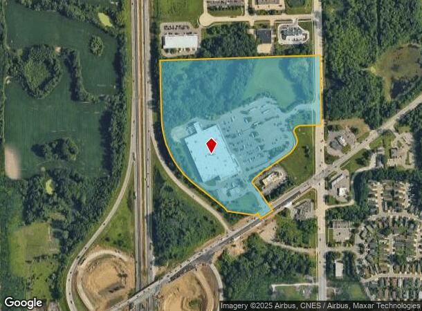
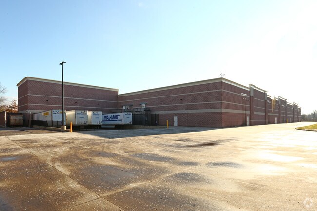
5450 Carpenter Rd, Ypsilanti, MI 48197

NEARBY LISTINGS FOR SALE OR LEASE
Property Detail
5450 Carpenter Rd
12-23-100-019
REWRITE PER SURVEY 04/11/03 PI 23-1A-1A-2A-1 SAM'S CLUB P.U.D. COM AT E 1/4 COR SEC 23
Commercialnec
Washtenaw
X
Michigan
26161C0410E
30.91 AC
2025
Washtenaw E of 23
2025
Detroit
416000
Ann Arbor, MI
132,290 SF
DEMOGRAPHICS near 5450 Carpenter Rd
1 Mile
3 Mile
5 Mile
2024 Total Population
4,333
40,469
124,344
2029 Population
4,220
39,925
122,813
Pop Growth 2024-2029
(2.61%)
(1.34%)
(1.23%)
Average Age
37
39
38
2024 Total Households
1,783
16,587
52,318
HH Growth 2024-2029
(2.92%)
(1.60%)
(1.36%)
Median Household Inc
$85,070
$70,536
$71,721
Avg Household Size
2.40
2.30
2.20
2024 Avg HH Vehicles
2.00
2.00
2.00
Median Home Value
$258,997
$271,061
$303,219
Median Year Built
1995
1979
1978
Nearby Places
Map Layers
Map Styles
 Street
 Aerial
- Restaurants
- Banks
- Shops
- Fitness
- Groceries
PUBLIC TRANSPORTATION
COMMUTER RAIL
Ann Arbor Amtrak Station (Wolverine - Amtrak)
DRIVE
WALK
Distance
Ann Arbor Amtrak Station (Wolverine - Amtrak)
14 min
8.1 mi
AIRPORT
Detroit Metro Wayne County
DRIVE
WALK
Distance
Detroit Metro Wayne County
27 min
20.3 mi
Freight Ports
Port of Toledo
DRIVE
WALK
Distance
Port of Toledo
68 min
52.5 mi
Nearby Properties
Address
Land Use
TOTAL SIZE
Lot Size
Zoning
Address
Land Use
TOTAL SIZE
Lot Size
Zoning
36,000 SF
27.61 AC
BI
Address
Land Use
TOTAL SIZE
Lot Size
Zoning
112,994 SF
45.12 AC
IH
Address
Land Use
TOTAL SIZE
Lot Size
Zoning
140,039 SF
Address
Land Use
TOTAL SIZE
Lot Size
Zoning
37,500 SF
25.94 AC
BI
Address
Land Use
TOTAL SIZE
Lot Size
Zoning
253,702 SF
30.23 AC
Address
Land Use
TOTAL SIZE
Lot Size
Zoning
17,672 SF
33.37 AC
BI
Address
Land Use
TOTAL SIZE
Lot Size
Zoning
32,040 SF
22.33 AC
BI
Address
Land Use
TOTAL SIZE
Lot Size
Zoning
27,603 SF
35.42 AC
BI
Address
Land Use
TOTAL SIZE
Lot Size
Zoning
111,435 SF
21.38 AC
R4B
Address
Land Use
TOTAL SIZE
Lot Size
Zoning
317,872 SF
11.79 AC
M1
Address
Land Use
TOTAL SIZE
Lot Size
Zoning
18,148 SF
21.62 AC
BI
Address
Land Use
TOTAL SIZE
Lot Size
Zoning
13,224 SF
24.30 AC
BI
Address
Land Use
TOTAL SIZE
Lot Size
Zoning
167,294 SF
40.67 AC
Address
Land Use
TOTAL SIZE
Lot Size
Zoning
159,947 SF
14.19 AC
Address
Land Use
TOTAL SIZE
Lot Size
Zoning
132,937 SF
13.92 AC
R4A
Address
Land Use
TOTAL SIZE
Lot Size
Zoning
8.02 AC
R4B
Address
Land Use
TOTAL SIZE
Lot Size
Zoning
18,110 SF
14.80 AC
BI
Address
Land Use
TOTAL SIZE
Lot Size
Zoning
136,968 SF
10.53 AC
R4A
Address
Land Use
TOTAL SIZE
Lot Size
Zoning
222,002 SF
26.04 AC
Address
Land Use
TOTAL SIZE
Lot Size
Zoning
159,208 SF
18.73 AC
R3
Address
Land Use
TOTAL SIZE
Lot Size
Zoning
64,989 SF
9.03 AC
R4A
Address
Land Use
TOTAL SIZE
Lot Size
Zoning
119,320 SF
6.13 AC
ME
Address
Land Use
TOTAL SIZE
Lot Size
Zoning
12,747 SF
22.86 AC
BA
Address
Land Use
TOTAL SIZE
Lot Size
Zoning
32,974 SF
29.96 AC
BA
Address
Land Use
TOTAL SIZE
Lot Size
Zoning
17,228 SF
8.40 AC
Address
Land Use
TOTAL SIZE
Lot Size
Zoning
11,630 SF
17.36 AC
BA
Address
Land Use
TOTAL SIZE
Lot Size
Zoning
259,778 SF
25.39 AC
Address
Land Use
TOTAL SIZE
Lot Size
Zoning
132,379 SF
27.35 AC
Address
Land Use
TOTAL SIZE
Lot Size
Zoning
57,842 SF
3.36 AC
O
Address
Land Use
TOTAL SIZE
Lot Size
Zoning
4,964 SF
5.86 AC
The World's #1 Commercial Real Estate Marketplace
Connect with us
© 2026 CoStar Group
The information above has been obtained from sources believed reliable. While we do not doubt its accuracy we have not verified it and make no guarantee, warranty or representation about it. It is your responsibility to independently confirm its accuracy and completeness. Any projections, opinions, assumptions, or estimates used are for example only and do not represent the current or future performance of the property. The value of this transaction to you depends on tax and other factors which should be evaluated by your tax, financial, and legal advisors. You and your advisors should conduct a careful, independent investigation of the property to determine to your satisfaction the suitability of the property for your needs.