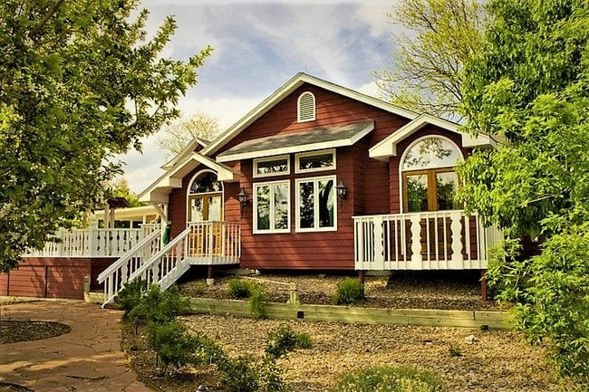
Property Record
5450 Manhart St, Sedalia, CO 80135


NEARBY LISTINGS FOR SALE OR LEASE
-
-
View all Sedalia listings for sale on LoopNet.com
Property Detail
5450 Manhart St
Denver-Aurora-Lakewood, CO
Sedalia Town Of
2353-144-08-012
LOTS 9, 10, 11, 12, 13 & 14 BLK 7 AND W1/2 OF VACATED KARCHER STREET ADJACENT TO LOT 9 TOWN OF SEDALIA 1.085 AM/L
Commercialnec
Douglas
X
Colorado
08035C0162F
9
2024
1.09 AC
2025
Southeast Outlying
014135
Denver
6,630 SF
DEMOGRAPHICS near 5450 Manhart St
1 Mile
3 Mile
5 Mile
2024 Total Population
226
2,079
41,206
2029 Population
255
2,374
46,943
Pop Growth 2024-2029
+ 12.83%
+ 14.19%
+ 13.92%
Average Age
39
47
40
2024 Total Households
70
747
14,276
HH Growth 2024-2029
+ 12.86%
+ 14.19%
+ 14.09%
Median Household Inc
$239,535
$192,399
$149,696
Avg Household Size
3.10
2.70
2.80
2024 Avg HH Vehicles
3.00
3.00
2.00
Median Home Value
$1,083,333
$1,050,117
$726,759
Median Year Built
2010
1997
2004
Nearby Places
Map Layers
Map Styles
 Street
 Aerial
- Restaurants
- Banks
- Shops
- Fitness
- Groceries
SALE & LEASE HISTORY
LISTING DATE
SALE/LEASE

May 02, 2018
For Sale
Jan 09, 2018
For Sale
Aug 11, 2017
For Sale
Apr 24, 2024
For Sale
Nearby Properties
Address
Land Use
TOTAL SIZE
Lot Size
Zoning
Address
Land Use
TOTAL SIZE
Lot Size
Zoning
29,950 SF
4.53 AC
GI
Address
Land Use
TOTAL SIZE
Lot Size
Zoning
2,338 SF
320 AC
A1
Address
Land Use
TOTAL SIZE
Lot Size
Zoning
30,357 SF
1.90 AC
GI
Address
Land Use
TOTAL SIZE
Lot Size
Zoning
20,732 SF
2.97 AC
GI
Address
Land Use
TOTAL SIZE
Lot Size
Zoning
14,380 SF
3.11 AC
Address
Land Use
TOTAL SIZE
Lot Size
Zoning
2,448 SF
11.64 AC
Address
Land Use
TOTAL SIZE
Lot Size
Zoning
9,869 SF
1.34 AC
GI
Address
Land Use
TOTAL SIZE
Lot Size
Zoning
23,014 SF
4.51 AC
RR
Address
Land Use
TOTAL SIZE
Lot Size
Zoning
9,600 SF
1.17 AC
GI
Address
Land Use
TOTAL SIZE
Lot Size
Zoning
26,505 SF
169.55 AC
A1
Address
Land Use
TOTAL SIZE
Lot Size
Zoning
7,953 SF
2.29 AC
GI
Address
Land Use
TOTAL SIZE
Lot Size
Zoning
19,375 SF
6.45 AC
GI
Address
Land Use
TOTAL SIZE
Lot Size
Zoning
5,865 SF
1.41 AC
B
Address
Land Use
TOTAL SIZE
Lot Size
Zoning
9,633 SF
2.13 AC
GI
Address
Land Use
TOTAL SIZE
Lot Size
Zoning
5,400 SF
2.21 AC
LI
Address
Land Use
TOTAL SIZE
Lot Size
Zoning
6,950 SF
4.77 AC
GI
Address
Land Use
TOTAL SIZE
Lot Size
Zoning
6,000 SF
4.90 AC
GI
Address
Land Use
TOTAL SIZE
Lot Size
Zoning
145 AC
A1
Address
Land Use
TOTAL SIZE
Lot Size
Zoning
11,464 SF
4.52 AC
GI
Address
Land Use
TOTAL SIZE
Lot Size
Zoning
6,000 SF
2.21 AC
Address
Land Use
TOTAL SIZE
Lot Size
Zoning
5,100 SF
2.11 AC
GI
Address
Land Use
TOTAL SIZE
Lot Size
Zoning
6,143 SF
0.53 AC
LI
Address
Land Use
TOTAL SIZE
Lot Size
Zoning
5,227 SF
0.75 AC
LI
Address
Land Use
TOTAL SIZE
Lot Size
Zoning
3,240 SF
5.16 AC
GI
Address
Land Use
TOTAL SIZE
Lot Size
Zoning
4,350 SF
4 AC
GI
Address
Land Use
TOTAL SIZE
Lot Size
Zoning
6,000 SF
14 AC
GI
Address
Land Use
TOTAL SIZE
Lot Size
Zoning
1,116 SF
77.91 AC
A1
Address
Land Use
TOTAL SIZE
Lot Size
Zoning
4.89 AC
GI
Address
Land Use
TOTAL SIZE
Lot Size
Zoning
4.78 AC
GI
The World's #1 Commercial Real Estate Marketplace
Connect with us
© 2025 CoStar Group
The information above has been obtained from sources believed reliable. While we do not doubt its accuracy we have not verified it and make no guarantee, warranty or representation about it. It is your responsibility to independently confirm its accuracy and completeness. Any projections, opinions, assumptions, or estimates used are for example only and do not represent the current or future performance of the property. The value of this transaction to you depends on tax and other factors which should be evaluated by your tax, financial, and legal advisors. You and your advisors should conduct a careful, independent investigation of the property to determine to your satisfaction the suitability of the property for your needs.