Property Record
5450 Millstream Rd, Mc Leansville, NC 27301


Save to a Folder
{{folder.Name}}
{{folder.ListingIds.length}} Properties
{{folder.ListingIds.length}} Property
Create a New Folder
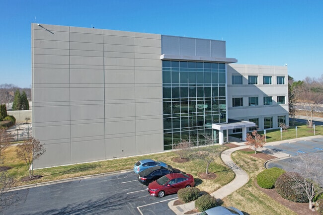
Property Detail
5450 Millstream Rd
0084849
LABCORPS BUILDING/PB 158-17 LO:1 PL:157-69
Industrialgeneral
GUILFORD
BP
North Carolina
B and X Area of moderate flood hazard, usually the area between the limits of the 100-year and 500-year floods.
1
2024
20.81 AC
2025
SE Guilford County
017200
Greensboro/Winston-Salem
177,717 SF
Greensboro-High Point, NC
NEARBY LISTINGS FOR SALE OR LEASE
-
-
View all Mc Leansville listings for lease on LoopNet.com
DEMOGRAPHICS near 5450 Millstream Rd
1 mile
3 mile
5 mile
2025 Total Population
401
12,076
30,363
2030 Population
410
12,435
31,306
Pop Growth 2025-2030
+ 2.24%
+ 2.97%
+ 3.11%
Average Age
40
40
40
2025 Total Households
147
4,650
11,679
HH Growth 2025-2030
+ 2.72%
+ 3.20%
+ 3.30%
Median Household Inc
$84,677
$78,815
$73,530
Avg Household Size
2.60
2.50
2.60
2025 Avg HH Vehicles
2.00
2.00
2.00
Median Home Value
$275,714
$272,590
$269,217
Median Year Built
1998
1997
1998
Nearby Places
Map Layers
Map Styles
 Street
 Aerial
Layers
 Traffic
 Biking
Places
Listings with unknown addresses are not visible on the map
- Restaurants
- Banks
- Shops
- Fitness
- Groceries
PUBLIC TRANSPORTATION
COMMUTER RAIL
Greensboro Station (Piedmont - North Carolina by Train (NC Train))
Drive
Walk
Distance
Greensboro Station (Piedmont - North Carolina by Train (NC Train))
16 min
9.8 mi
AIRPORT
Piedmont Triad International
Drive
Walk
Distance
Piedmont Triad International
33 min
20.1 mi
Freight Ports
Virginia Port Authority - Richmond
Drive
Walk
Distance
Virginia Port Authority - Richmond
219 min
190.3 mi
SALE & LEASE HISTORY
LISTING DATE
SALE/LEASE

Jan 08, 2024
For Lease
Aug 19, 2022
For Lease
Aug 14, 2024
For Lease
Apr 16, 2024
For Lease
Apr 04, 2019
For Sale
Nearby Properties
Address
Land Use
TOTAL SIZE
Lot Size
Zoning
Address
Land Use
TOTAL SIZE
Lot Size
Zoning
2,340,205 SF
338.69 AC
LI
Address
Land Use
TOTAL SIZE
Lot Size
Zoning
495,280 SF
105.18 AC
LI
Address
Land Use
TOTAL SIZE
Lot Size
Zoning
414,500 SF
103.57 AC
PI
Address
Land Use
TOTAL SIZE
Lot Size
Zoning
364,783 SF
30.12 AC
RM-18
Address
Land Use
TOTAL SIZE
Lot Size
Zoning
418,596 SF
23.53 AC
LI
Address
Land Use
TOTAL SIZE
Lot Size
Zoning
505,615 SF
39.50 AC
LI
Address
Land Use
TOTAL SIZE
Lot Size
Zoning
93,763 SF
33.51 AC
LI
Address
Land Use
TOTAL SIZE
Lot Size
Zoning
419,126 SF
33.68 AC
LI
Address
Land Use
TOTAL SIZE
Lot Size
Zoning
235,503 SF
38.75 AC
LI
Address
Land Use
TOTAL SIZE
Lot Size
Zoning
246,317 SF
18.72 AC
PD-R
Address
Land Use
TOTAL SIZE
Lot Size
Zoning
260,000 SF
20.35 AC
LI
Address
Land Use
TOTAL SIZE
Lot Size
Zoning
240,170 SF
14.01 AC
LI
Address
Land Use
TOTAL SIZE
Lot Size
Zoning
162,161 SF
19.18 AC
RM-8
Address
Land Use
TOTAL SIZE
Lot Size
Zoning
301,592 SF
19.38 AC
LI
Address
Land Use
TOTAL SIZE
Lot Size
Zoning
652,985 SF
104.62 AC
BP
Address
Land Use
TOTAL SIZE
Lot Size
Zoning
128,500 SF
14.15 AC
LI
Address
Land Use
TOTAL SIZE
Lot Size
Zoning
271,850 SF
25.24 AC
LI
Address
Land Use
TOTAL SIZE
Lot Size
Zoning
85,715 SF
15.34 AC
PUD
Address
Land Use
TOTAL SIZE
Lot Size
Zoning
92,497 SF
22.35 AC
LI
Address
Land Use
TOTAL SIZE
Lot Size
Zoning
146,028 SF
11.36 AC
BP
Address
Land Use
TOTAL SIZE
Lot Size
Zoning
67,872 SF
9.94 AC
GO-M
Address
Land Use
TOTAL SIZE
Lot Size
Zoning
86,400 SF
7.11 AC
BP
Address
Land Use
TOTAL SIZE
Lot Size
Zoning
57,829 SF
2.65 AC
LI
Address
Land Use
TOTAL SIZE
Lot Size
Zoning
90,000 SF
8.95 AC
LI
Address
Land Use
TOTAL SIZE
Lot Size
Zoning
37,100 SF
3.53 AC
HB
Address
Land Use
TOTAL SIZE
Lot Size
Zoning
218,126 SF
22.41 AC
LI
Address
Land Use
TOTAL SIZE
Lot Size
Zoning
109,962 SF
15 AC
LI
Address
Land Use
TOTAL SIZE
Lot Size
Zoning
58,144 SF
10.84 AC
CD-SC
Address
Land Use
TOTAL SIZE
Lot Size
Zoning
45,878 SF
1.68 AC
LI
The World's #1 Commercial Real Estate Marketplace
Connect with us
© 2026 CoStar Group
The information above has been obtained from sources believed reliable. While we do not doubt its accuracy we have not verified it and make no guarantee, warranty or representation about it. It is your responsibility to independently confirm its accuracy and completeness. Any projections, opinions, assumptions, or estimates used are for example only and do not represent the current or future performance of the property. The value of this transaction to you depends on tax and other factors which should be evaluated by your tax, financial, and legal advisors. You and your advisors should conduct a careful, independent investigation of the property to determine to your satisfaction the suitability of the property for your needs.