Property Record
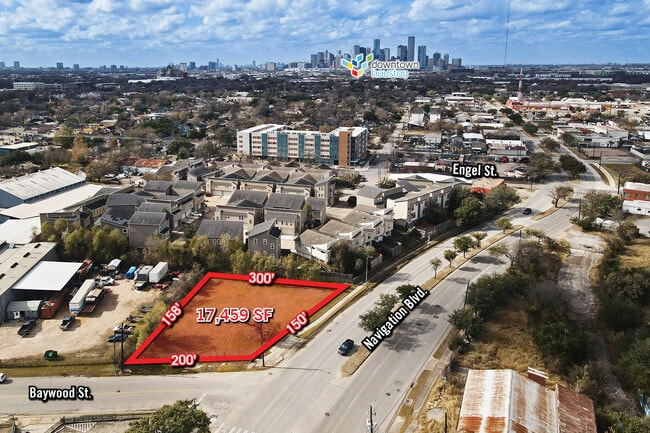
5450 Navigation Blvd, Houston, TX 77011


NEARBY LISTINGS FOR SALE OR LEASE
Property Detail
5450 Navigation Blvd
Houston-The Woodlands-Sugar Land, TX
Burnett Vista
1403270010001
RES A BLK 1 BURNETT VISTA
Commercialacreage
Harris
X
Texas
48201C0880M
0.40 AC
2024
Gulf Freeway/Pasadena
2025
Houston
310500
DEMOGRAPHICS near 5450 Navigation Blvd
1 Mile
3 Mile
5 Mile
2024 Total Population
13,305
144,445
376,445
2029 Population
13,760
149,517
390,496
Pop Growth 2024-2029
+ 3.42%
+ 3.51%
+ 3.73%
Average Age
39
37
37
2024 Total Households
4,994
50,666
149,812
HH Growth 2024-2029
+ 3.42%
+ 4.17%
+ 4.10%
Median Household Inc
$39,112
$44,404
$54,143
Avg Household Size
2.60
2.40
2.30
2024 Avg HH Vehicles
1.00
1.00
2.00
Median Home Value
$244,382
$203,886
$234,621
Median Year Built
1949
1960
1973
Nearby Places
Map Layers
Map Styles
 Street
 Aerial
- Restaurants
- Banks
- Shops
- Fitness
- Groceries
PUBLIC TRANSPORTATION
COMMUTER RAIL
DRIVE
WALK
Distance
8 min
3.6 mi
AIRPORT
William P Hobby
DRIVE
WALK
Distance
William P Hobby
22 min
10.6 mi
George Bush Intcntl/Houston
DRIVE
WALK
Distance
George Bush Intcntl/Houston
29 min
20.0 mi
Freight Ports
Port of Houston
DRIVE
WALK
Distance
Port of Houston
13 min
5.6 mi
SALE & LEASE HISTORY
LISTING DATE
SALE/LEASE

Sep 24, 2016
For Sale
May 24, 2017
For Sale
Jan 11, 2023
For Sale
Nearby Properties
Address
Land Use
TOTAL SIZE
Lot Size
Zoning
Address
Land Use
TOTAL SIZE
Lot Size
Zoning
1,383,720 SF
1.47 AC
Address
Land Use
TOTAL SIZE
Lot Size
Zoning
1,101,686 SF
1.45 AC
Address
Land Use
TOTAL SIZE
Lot Size
Zoning
973,861 SF
1.18 AC
Address
Land Use
TOTAL SIZE
Lot Size
Zoning
899,279 SF
1.18 AC
Address
Land Use
TOTAL SIZE
Lot Size
Zoning
797,208 SF
1.46 AC
Address
Land Use
TOTAL SIZE
Lot Size
Zoning
1,916,394 SF
1.46 AC
Address
Land Use
TOTAL SIZE
Lot Size
Zoning
1,091,726 SF
2.60 AC
Address
Land Use
TOTAL SIZE
Lot Size
Zoning
1,321,033 SF
1.46 AC
Address
Land Use
TOTAL SIZE
Lot Size
Zoning
515,025 SF
1.50 AC
Address
Land Use
TOTAL SIZE
Lot Size
Zoning
1,657,484 SF
1.44 AC
Address
Land Use
TOTAL SIZE
Lot Size
Zoning
1,311,133 SF
1.44 AC
Address
Land Use
TOTAL SIZE
Lot Size
Zoning
1,181,384 SF
1.47 AC
Address
Land Use
TOTAL SIZE
Lot Size
Zoning
934,258 SF
1.45 AC
Address
Land Use
TOTAL SIZE
Lot Size
Zoning
1,103,424 SF
1.44 AC
Address
Land Use
TOTAL SIZE
Lot Size
Zoning
1,365,801 SF
1.44 AC
Address
Land Use
TOTAL SIZE
Lot Size
Zoning
1,017,783 SF
1.44 AC
Address
Land Use
TOTAL SIZE
Lot Size
Zoning
1,182,525 SF
1.11 AC
Address
Land Use
TOTAL SIZE
Lot Size
Zoning
612,078 SF
1.44 AC
Address
Land Use
TOTAL SIZE
Lot Size
Zoning
468,513 SF
0.86 AC
Address
Land Use
TOTAL SIZE
Lot Size
Zoning
1,392,720 SF
83.75 AC
Address
Land Use
TOTAL SIZE
Lot Size
Zoning
1,102,279 SF
1.44 AC
Address
Land Use
TOTAL SIZE
Lot Size
Zoning
396,910 SF
0.44 AC
Address
Land Use
TOTAL SIZE
Lot Size
Zoning
1,008,419 SF
1.44 AC
Address
Land Use
TOTAL SIZE
Lot Size
Zoning
656,994 SF
4.01 AC
Address
Land Use
TOTAL SIZE
Lot Size
Zoning
596,700 SF
0.82 AC
Address
Land Use
TOTAL SIZE
Lot Size
Zoning
360,043 SF
0.81 AC
Address
Land Use
TOTAL SIZE
Lot Size
Zoning
575,578 SF
1.46 AC
Address
Land Use
TOTAL SIZE
Lot Size
Zoning
766,950 SF
1.45 AC
Address
Land Use
TOTAL SIZE
Lot Size
Zoning
644,794 SF
3.38 AC
Address
Land Use
TOTAL SIZE
Lot Size
Zoning
1,526,323 SF
2.87 AC
The World's #1 Commercial Real Estate Marketplace
Connect with us
© 2025 CoStar Group
The information above has been obtained from sources believed reliable. While we do not doubt its accuracy we have not verified it and make no guarantee, warranty or representation about it. It is your responsibility to independently confirm its accuracy and completeness. Any projections, opinions, assumptions, or estimates used are for example only and do not represent the current or future performance of the property. The value of this transaction to you depends on tax and other factors which should be evaluated by your tax, financial, and legal advisors. You and your advisors should conduct a careful, independent investigation of the property to determine to your satisfaction the suitability of the property for your needs.