Property Record
5450 W Belmont Ave, Fresno, CA 93723
NEARBY LISTINGS FOR SALE OR LEASE
-
-
View all Fresno listings for sale on LoopNet.com
Property Detail
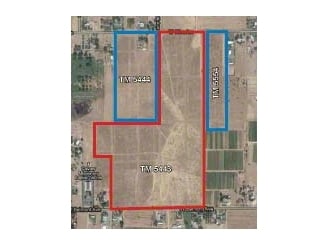
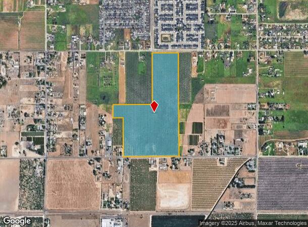
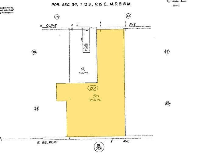
5450 W Belmont Ave
312-261-03S
SUR RTS 64.55 ACS IN S1/2 OF SEC 34 T13R19
Orchard
Fresno
X
California
06019C1545H
64.55 AC
2025
West Fresno
2025
Fresno
003812
Fresno, CA
DEMOGRAPHICS near 5450 W Belmont Ave
1 Mile
3 Mile
5 Mile
2024 Total Population
4,398
42,102
153,509
2029 Population
4,493
42,842
156,854
Pop Growth 2024-2029
+ 2.16%
+ 1.76%
+ 2.18%
Average Age
35
34
35
2024 Total Households
1,142
11,870
48,548
HH Growth 2024-2029
+ 2.10%
+ 1.74%
+ 2.17%
Median Household Inc
$72,315
$65,046
$57,898
Avg Household Size
3.80
3.40
3.00
2024 Avg HH Vehicles
2.00
2.00
2.00
Median Home Value
$373,529
$292,232
$280,229
Median Year Built
2004
1989
1977
Nearby Places
Map Layers
Map Styles
 Street
 Aerial
- Restaurants
- Banks
- Shops
- Fitness
- Groceries
PUBLIC TRANSPORTATION
COMMUTER RAIL
Fresno (San Joaquins - Amtrak)
DRIVE
WALK
Distance
Fresno (San Joaquins - Amtrak)
13 min
6.8 mi
AIRPORT
Fresno Yosemite International
DRIVE
WALK
Distance
Fresno Yosemite International
19 min
12.0 mi
Freight Ports
Port of Stockton
DRIVE
WALK
Distance
Port of Stockton
151 min
124.9 mi
Nearby Properties
Address
Land Use
TOTAL SIZE
Lot Size
Zoning
Address
Land Use
TOTAL SIZE
Lot Size
Zoning
159,822 SF
9.67 AC
R2
Address
Land Use
TOTAL SIZE
Lot Size
Zoning
145,783 SF
9.22 AC
R2
Address
Land Use
TOTAL SIZE
Lot Size
Zoning
106,740 SF
63.59 AC
AE20
Address
Land Use
TOTAL SIZE
Lot Size
Zoning
103,088 SF
5.41 AC
R3
Address
Land Use
TOTAL SIZE
Lot Size
Zoning
84,050 SF
6.84 AC
R3
Address
Land Use
TOTAL SIZE
Lot Size
Zoning
84,309 SF
3.97 AC
R3
Address
Land Use
TOTAL SIZE
Lot Size
Zoning
74,212 SF
4.38 AC
R3
Address
Land Use
TOTAL SIZE
Lot Size
Zoning
86,559 SF
5.40 AC
R3
Address
Land Use
TOTAL SIZE
Lot Size
Zoning
127,758 SF
7.82 AC
R3
Address
Land Use
TOTAL SIZE
Lot Size
Zoning
63,250 SF
3.67 AC
C6
Address
Land Use
TOTAL SIZE
Lot Size
Zoning
88,327 SF
7.61 AC
R2A
Address
Land Use
TOTAL SIZE
Lot Size
Zoning
50,318 SF
5.01 AC
C1
Address
Land Use
TOTAL SIZE
Lot Size
Zoning
61,950 SF
3.11 AC
R3
Address
Land Use
TOTAL SIZE
Lot Size
Zoning
208,150 SF
21.49 AC
CM
Address
Land Use
TOTAL SIZE
Lot Size
Zoning
61,950 SF
3.40 AC
R3
Address
Land Use
TOTAL SIZE
Lot Size
Zoning
47,175 SF
11.63 AC
M3
Address
Land Use
TOTAL SIZE
Lot Size
Zoning
26.15 AC
M3
Address
Land Use
TOTAL SIZE
Lot Size
Zoning
14,740 SF
1.95 AC
C1
Address
Land Use
TOTAL SIZE
Lot Size
Zoning
14,405 SF
1.46 AC
C1
Address
Land Use
TOTAL SIZE
Lot Size
Zoning
55,880 SF
4.64 AC
R2
Address
Land Use
TOTAL SIZE
Lot Size
Zoning
4,037 SF
1.28 AC
C6
Address
Land Use
TOTAL SIZE
Lot Size
Zoning
6,255 SF
1.09 AC
C6
Address
Land Use
TOTAL SIZE
Lot Size
Zoning
22.24 AC
M3
Address
Land Use
TOTAL SIZE
Lot Size
Zoning
54,928 SF
6.22 AC
SL
Address
Land Use
TOTAL SIZE
Lot Size
Zoning
26,640 SF
2.93 AC
C6
Address
Land Use
TOTAL SIZE
Lot Size
Zoning
26,341 SF
4.77 AC
AE5
Address
Land Use
TOTAL SIZE
Lot Size
Zoning
176,596 SF
9.60 AC
C6
Address
Land Use
TOTAL SIZE
Lot Size
Zoning
13,126 SF
0.95 AC
C1
Address
Land Use
TOTAL SIZE
Lot Size
Zoning
49,471 SF
6.78 AC
M1
Address
Land Use
TOTAL SIZE
Lot Size
Zoning
6.51 AC
RR
The World's #1 Commercial Real Estate Marketplace
Connect with us
© 2026 CoStar Group
The information above has been obtained from sources believed reliable. While we do not doubt its accuracy we have not verified it and make no guarantee, warranty or representation about it. It is your responsibility to independently confirm its accuracy and completeness. Any projections, opinions, assumptions, or estimates used are for example only and do not represent the current or future performance of the property. The value of this transaction to you depends on tax and other factors which should be evaluated by your tax, financial, and legal advisors. You and your advisors should conduct a careful, independent investigation of the property to determine to your satisfaction the suitability of the property for your needs.