Property Record
5452 E Lake Rd, Dewittville, NY 14728
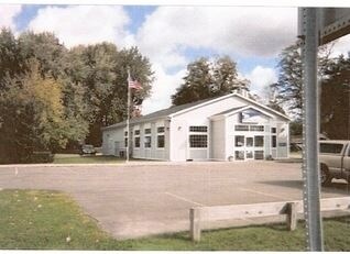

Property Detail
5452 E Lake Rd
Jamestown-Dunkirk, NY
INC 32-2-8.1; OLD APN: 062889 32-2-9
062889-263-020-0002-016-000
CHAUTAUQUA
Officebuilding
New York
05 - COMME
16.000
2025
1.15 AC
2025
New York West Area
036402
Other Market Areas
3,208 SF
NEARBY LISTINGS FOR SALE OR LEASE
DEMOGRAPHICS near 5452 E Lake Rd
1 mile
3 mile
5 mile
2025 Total Population
339
3,945
6,773
2030 Population
362
4,256
7,174
Pop Growth 2025-2030
+ 6.78%
+ 7.88%
+ 5.92%
Average Age
48
48
47
2025 Total Households
149
1,776
2,988
HH Growth 2025-2030
+ 6.71%
+ 8.39%
+ 6.26%
Median Household Inc
$92,577
$74,441
$75,030
Avg Household Size
2.30
2.10
2.10
2025 Avg HH Vehicles
2.00
2.00
2.00
Median Home Value
$137,500
$274,999
$233,496
Median Year Built
1965
1969
1966
Nearby Places
Map Layers
Map Styles
 Street
 Aerial
Layers
 Traffic
 Biking
Places
Listings with unknown addresses are not visible on the map
- Restaurants
- Banks
- Shops
- Fitness
- Groceries
Nearby Properties
Address
Land Use
TOTAL SIZE
Lot Size
Zoning
Address
Land Use
TOTAL SIZE
Lot Size
Zoning
48,404 SF
2.20 AC
07 - MIXED
Address
Land Use
TOTAL SIZE
Lot Size
Zoning
5,204 SF
3.70 AC
07 - MIXED
Address
Land Use
TOTAL SIZE
Lot Size
Zoning
10,660 SF
9.60 AC
07 - MIXED
Address
Land Use
TOTAL SIZE
Lot Size
Zoning
46,074 SF
17.40 AC
03 - MULTI
Address
Land Use
TOTAL SIZE
Lot Size
Zoning
0.01 AC
Address
Land Use
TOTAL SIZE
Lot Size
Zoning
6,108 SF
24.90 AC
03 - MULTI
Address
Land Use
TOTAL SIZE
Lot Size
Zoning
4,944 SF
0.44 AC
07 - MIXED
Address
Land Use
TOTAL SIZE
Lot Size
Zoning
29,157 SF
2.30 AC
07 - MIXED
Address
Land Use
TOTAL SIZE
Lot Size
Zoning
71,182 SF
1.46 AC
07 - MIXED
Address
Land Use
TOTAL SIZE
Lot Size
Zoning
46,452 SF
2.50 AC
07 - MIXED
Address
Land Use
TOTAL SIZE
Lot Size
Zoning
4,428 SF
1.80 AC
07 - MIXED
Address
Land Use
TOTAL SIZE
Lot Size
Zoning
0.01 AC
Address
Land Use
TOTAL SIZE
Lot Size
Zoning
7,788 SF
30.20 AC
02 - SINGL
Address
Land Use
TOTAL SIZE
Lot Size
Zoning
1,944 SF
1.13 AC
07 - MIXED
Address
Land Use
TOTAL SIZE
Lot Size
Zoning
156 SF
4.50 AC
07
Address
Land Use
TOTAL SIZE
Lot Size
Zoning
3,240 SF
0.92 AC
07 - MIXED
Address
Land Use
TOTAL SIZE
Lot Size
Zoning
4,311 SF
0.07 AC
07 - MIXED
Address
Land Use
TOTAL SIZE
Lot Size
Zoning
1,152 SF
4.80 AC
07 - MIXED
Address
Land Use
TOTAL SIZE
Lot Size
Zoning
9,948 SF
42.60 AC
03 - MULTI
Address
Land Use
TOTAL SIZE
Lot Size
Zoning
18,168 SF
3.80 AC
07 - MIXED
Address
Land Use
TOTAL SIZE
Lot Size
Zoning
5,000 SF
21.60 AC
05 - COMME
Address
Land Use
TOTAL SIZE
Lot Size
Zoning
4,550 SF
3.90 AC
07 - MIXED
Address
Land Use
TOTAL SIZE
Lot Size
Zoning
5,668 SF
2.80 AC
07 - MIXED
Address
Land Use
TOTAL SIZE
Lot Size
Zoning
3,300 SF
13.73 AC
05 - COMME
Address
Land Use
TOTAL SIZE
Lot Size
Zoning
4,640 SF
0.78 AC
07 - MIXED
Address
Land Use
TOTAL SIZE
Lot Size
Zoning
4,106 SF
123 AC
04 - FARM
Address
Land Use
TOTAL SIZE
Lot Size
Zoning
10,527 SF
1.70 AC
07 - MIXED
Address
Land Use
TOTAL SIZE
Lot Size
Zoning
8,619 SF
0.33 AC
07 - MIXED
Address
Land Use
TOTAL SIZE
Lot Size
Zoning
Address
Land Use
TOTAL SIZE
Lot Size
Zoning
6,354 SF
67.50 AC
05 - COMME
The World's #1 Commercial Real Estate Marketplace
Connect with us
© 2026 CoStar Group
The information above has been obtained from sources believed reliable. While we do not doubt its accuracy we have not verified it and make no guarantee, warranty or representation about it. It is your responsibility to independently confirm its accuracy and completeness. Any projections, opinions, assumptions, or estimates used are for example only and do not represent the current or future performance of the property. The value of this transaction to you depends on tax and other factors which should be evaluated by your tax, financial, and legal advisors. You and your advisors should conduct a careful, independent investigation of the property to determine to your satisfaction the suitability of the property for your needs.