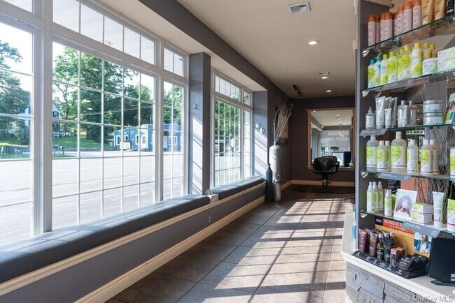
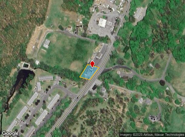
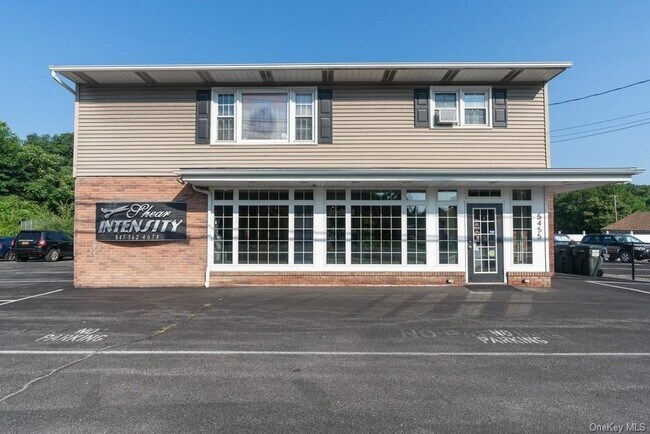
Property Record
5455 Route 9W, Newburgh, NY 12550
NEARBY LISTINGS FOR SALE OR LEASE
Property Detail
5455 Route 9W
334600-009-000-0001-008.000-0000
Orange
Commercialnec
New York
A
8.000
36027C0453E
0.34 AC
2024
Newburgh
2024
Northern New Jersey
010102
Kiryas Joel-Poughkeepsie-Newburgh, NY
2,160 SF
DEMOGRAPHICS near 5455 Route 9W
1 mile
3 mile
5 mile
2024 Total Population
2,278
16,999
77,465
2029 Population
2,306
17,047
77,976
Pop Growth 2024-2029
+ 1.23%
+ 0.28%
+ 0.66%
Average Age
40
41
41
2024 Total Households
926
6,608
29,872
HH Growth 2024-2029
+ 1.40%
+ 0.21%
+ 0.57%
Median Household Inc
$101,024
$105,653
$83,311
Avg Household Size
2.50
2.50
2.40
2024 Avg HH Vehicles
2.00
2.00
2.00
Median Home Value
$333,333
$371,896
$329,513
Median Year Built
1996
1981
1965
Nearby Places
Map Layers
Map Styles
 Street
 Aerial
Transit
 Traffic
 Biking
Places
Listings with unknown addresses are not visible on the map
- Restaurants
- Banks
- Shops
- Fitness
- Groceries
PUBLIC TRANSPORTATION
COMMUTER RAIL
Beacon Station (Hudson Line - Metro-North Commuter Railroad Company (Metro-North))
Drive
Walk
Distance
Beacon Station (Hudson Line - Metro-North Commuter Railroad Company (Metro-North))
15 min
7.6 mi
AIRPORT
New York Stewart International
Drive
Walk
Distance
New York Stewart International
18 min
11.3 mi
SALE & LEASE HISTORY
LISTING DATE
SALE/LEASE

Aug 07, 2020
For Sale
Nearby Properties
Address
Land Use
TOTAL SIZE
Lot Size
Zoning
Address
Land Use
TOTAL SIZE
Lot Size
Zoning
101,170 SF
28.71 AC
RMF5
Address
Land Use
TOTAL SIZE
Lot Size
Zoning
Address
Land Use
TOTAL SIZE
Lot Size
Zoning
114 AC
Address
Land Use
TOTAL SIZE
Lot Size
Zoning
293,984 SF
47.95 AC
RMF5
Address
Land Use
TOTAL SIZE
Lot Size
Zoning
94,340 SF
31.64 AC
RMF5
Address
Land Use
TOTAL SIZE
Lot Size
Zoning
21,996 SF
17.36 AC
RMF5
Address
Land Use
TOTAL SIZE
Lot Size
Zoning
466.77 AC
R40
Address
Land Use
TOTAL SIZE
Lot Size
Zoning
141,167 SF
46.50 AC
R1
Address
Land Use
TOTAL SIZE
Lot Size
Zoning
1,095 SF
21.70 AC
R1
Address
Land Use
TOTAL SIZE
Lot Size
Zoning
50.90 AC
Address
Land Use
TOTAL SIZE
Lot Size
Zoning
35 AC
R40
Address
Land Use
TOTAL SIZE
Lot Size
Zoning
43,877 SF
10.10 AC
R1
Address
Land Use
TOTAL SIZE
Lot Size
Zoning
Address
Land Use
TOTAL SIZE
Lot Size
Zoning
22 AC
R40
Address
Land Use
TOTAL SIZE
Lot Size
Zoning
11.20 AC
CC
Address
Land Use
TOTAL SIZE
Lot Size
Zoning
138.90 AC
Address
Land Use
TOTAL SIZE
Lot Size
Zoning
54,908 SF
7.60 AC
HD
Address
Land Use
TOTAL SIZE
Lot Size
Zoning
14.30 AC
RAG1
Address
Land Use
TOTAL SIZE
Lot Size
Zoning
32.30 AC
RMF5
Address
Land Use
TOTAL SIZE
Lot Size
Zoning
Address
Land Use
TOTAL SIZE
Lot Size
Zoning
11,367 SF
14.97 AC
R80
Address
Land Use
TOTAL SIZE
Lot Size
Zoning
8,599 SF
24.04 AC
R80
Address
Land Use
TOTAL SIZE
Lot Size
Zoning
50,657 SF
15.60 AC
R1
Address
Land Use
TOTAL SIZE
Lot Size
Zoning
6,320 SF
4.96 AC
R4A
Address
Land Use
TOTAL SIZE
Lot Size
Zoning
32,320 SF
2.51 AC
NB
Address
Land Use
TOTAL SIZE
Lot Size
Zoning
43,633 SF
99.63 AC
R80
Address
Land Use
TOTAL SIZE
Lot Size
Zoning
Address
Land Use
TOTAL SIZE
Lot Size
Zoning
28,422 SF
38.70 AC
R40/80
Address
Land Use
TOTAL SIZE
Lot Size
Zoning
40.30 AC
Address
Land Use
TOTAL SIZE
Lot Size
Zoning
3.50 AC
HB
The World's #1 Commercial Real Estate Marketplace
Connect with us
© 2026 CoStar Group
The information above has been obtained from sources believed reliable. While we do not doubt its accuracy we have not verified it and make no guarantee, warranty or representation about it. It is your responsibility to independently confirm its accuracy and completeness. Any projections, opinions, assumptions, or estimates used are for example only and do not represent the current or future performance of the property. The value of this transaction to you depends on tax and other factors which should be evaluated by your tax, financial, and legal advisors. You and your advisors should conduct a careful, independent investigation of the property to determine to your satisfaction the suitability of the property for your needs.