Property Record
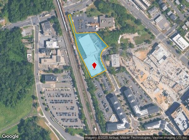
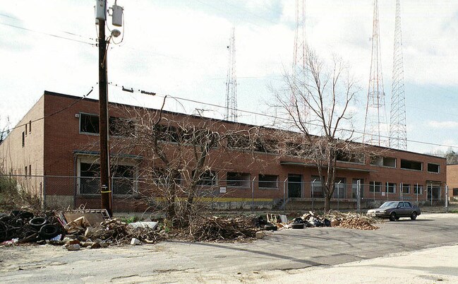
5458 3Rd St Ne, Washington, DC 20011

NEARBY LISTINGS FOR SALE OR LEASE
Property Detail
5458 3Rd St Ne
Washington-Arlington-Alexandria, DC-VA-MD-WV
Brookland
3766-0006
SQUARE 3766 LOT 0006 NBHD: BROOKLAND
Publichealthcarefacility
District of Columbia
X
District of Columbia
24033C0110E
6
2025
2.14 AC
2025
NE
009508
Washington, DC
56,097 SF
DEMOGRAPHICS near 5458 3Rd St Ne
1 Mile
3 Mile
5 Mile
2024 Total Population
32,999
305,783
752,234
2029 Population
30,162
285,365
705,781
Pop Growth 2024-2029
(8.60%)
(6.68%)
(6.18%)
Average Age
40
37
37
2024 Total Households
12,816
122,034
318,897
HH Growth 2024-2029
(9.49%)
(7.42%)
(7.20%)
Median Household Inc
$76,388
$87,266
$98,157
Avg Household Size
2.50
2.40
2.20
2024 Avg HH Vehicles
1.00
1.00
1.00
Median Home Value
$555,744
$637,974
$695,790
Median Year Built
1953
1953
1957
Nearby Places
Map Layers
Map Styles
 Street
 Aerial
- Restaurants
- Banks
- Shops
- Fitness
- Groceries
PUBLIC TRANSPORTATION
TRANSIT/SUBWAY
Fort Totten (Green Line - Washington Metropolitan Area Transit Authority Metrorail (Metrorail), Red Line - Washington Metropolitan Area Transit Authority Metrorail (Metrorail), Yellow Line - Washington Metropolitan Area Transit Authority Metrorail (Metrorail))
DRIVE
WALK
Distance
Fort Totten (Green Line - Washington Metropolitan Area Transit Authority Metrorail (Metrorail), Red Line - Washington Metropolitan Area Transit Authority Metrorail (Metrorail), Yellow Line - Washington Metropolitan Area Transit Authority Metrorail (Metrorail))
1 min
5 min
0.2 mi
COMMUTER RAIL
Silver Spring (Brunswick Line - Maryland Area Regional Commuter Trains (The MARC))
DRIVE
WALK
Distance
Silver Spring (Brunswick Line - Maryland Area Regional Commuter Trains (The MARC))
11 min
3.7 mi
Riverdale (Camden Line - Maryland Area Regional Commuter Trains (The MARC))
DRIVE
WALK
Distance
Riverdale (Camden Line - Maryland Area Regional Commuter Trains (The MARC))
10 min
4.7 mi
AIRPORT
Ronald Reagan Washington Ntl
DRIVE
WALK
Distance
Ronald Reagan Washington Ntl
21 min
10.2 mi
Baltimore/Washington International Thurgood Marshall
DRIVE
WALK
Distance
Baltimore/Washington International Thurgood Marshall
45 min
31.3 mi
Washington Dulles International
DRIVE
WALK
Distance
Washington Dulles International
54 min
33.0 mi
Freight Ports
Port of Baltimore
DRIVE
WALK
Distance
Port of Baltimore
48 min
34.0 mi
Nearby Properties
Address
Land Use
TOTAL SIZE
Lot Size
Zoning
Address
Land Use
TOTAL SIZE
Lot Size
Zoning
1,583,364 SF
276.66 AC
UNZONED
Address
Land Use
TOTAL SIZE
Lot Size
Zoning
1,562,988 SF
15.33 AC
MU-10 (IZ+
Address
Land Use
TOTAL SIZE
Lot Size
Zoning
95.32 AC
RA-1
Address
Land Use
TOTAL SIZE
Lot Size
Zoning
1,835,827 SF
34.66 AC
UNZONED
Address
Land Use
TOTAL SIZE
Lot Size
Zoning
791,730 SF
37.44 AC
RA-1
Address
Land Use
TOTAL SIZE
Lot Size
Zoning
1,095,275 SF
30.70 AC
MU-4;RA-2
Address
Land Use
TOTAL SIZE
Lot Size
Zoning
823,802 SF
7.30 AC
MU-2
Address
Land Use
TOTAL SIZE
Lot Size
Zoning
256,187 SF
8.97 AC
RA-2
Address
Land Use
TOTAL SIZE
Lot Size
Zoning
520,000 SF
2.65 AC
MU-10;RA-5
Address
Land Use
TOTAL SIZE
Lot Size
Zoning
248,643 SF
8.66 AC
RA-1
Address
Land Use
TOTAL SIZE
Lot Size
Zoning
1,201,133 SF
41.56 AC
RTOHC
Address
Land Use
TOTAL SIZE
Lot Size
Zoning
869,190 SF
4.97 AC
RA-1
Address
Land Use
TOTAL SIZE
Lot Size
Zoning
41.12 AC
RA-1
Address
Land Use
TOTAL SIZE
Lot Size
Zoning
400,000 SF
0.93 AC
CR5.0
Address
Land Use
TOTAL SIZE
Lot Size
Zoning
326,985 SF
1.13 AC
MU-6B
Address
Land Use
TOTAL SIZE
Lot Size
Zoning
309,621 SF
1.98 AC
Address
Land Use
TOTAL SIZE
Lot Size
Zoning
202,500 SF
0.53 AC
MU-10 (IZ+
Address
Land Use
TOTAL SIZE
Lot Size
Zoning
357,398 SF
0.72 AC
MU-5A
Address
Land Use
TOTAL SIZE
Lot Size
Zoning
319,450 SF
0.71 AC
MU-10
Address
Land Use
TOTAL SIZE
Lot Size
Zoning
169,500 SF
9.14 AC
RA-1
Address
Land Use
TOTAL SIZE
Lot Size
Zoning
492,835 SF
21.61 AC
RA-1
Address
Land Use
TOTAL SIZE
Lot Size
Zoning
4,924 SF
53.06 AC
R-3
Address
Land Use
TOTAL SIZE
Lot Size
Zoning
102,968 SF
18.08 AC
RF-1
Address
Land Use
TOTAL SIZE
Lot Size
Zoning
484,988 SF
1.87 AC
MU-4
Address
Land Use
TOTAL SIZE
Lot Size
Zoning
298,452 SF
0.93 AC
MU-10
Address
Land Use
TOTAL SIZE
Lot Size
Zoning
39,276 SF
22.97 AC
R-1A/FH
Address
Land Use
TOTAL SIZE
Lot Size
Zoning
347,234 SF
1.02 AC
ARTS-1;ART
Address
Land Use
TOTAL SIZE
Lot Size
Zoning
305,711 SF
0.84 AC
RA-2
Address
Land Use
TOTAL SIZE
Lot Size
Zoning
185,000 SF
4.30 AC
RA-2;RA-4
Address
Land Use
TOTAL SIZE
Lot Size
Zoning
12,498 SF
7.36 AC
RF-1
The World's #1 Commercial Real Estate Marketplace
Connect with us
© 2025 CoStar Group
The information above has been obtained from sources believed reliable. While we do not doubt its accuracy we have not verified it and make no guarantee, warranty or representation about it. It is your responsibility to independently confirm its accuracy and completeness. Any projections, opinions, assumptions, or estimates used are for example only and do not represent the current or future performance of the property. The value of this transaction to you depends on tax and other factors which should be evaluated by your tax, financial, and legal advisors. You and your advisors should conduct a careful, independent investigation of the property to determine to your satisfaction the suitability of the property for your needs.