Property Record
5459 N Tongass Hwy, Ketchikan, AK 99901

NEARBY LISTINGS FOR SALE OR LEASE
-
-
View all Ketchikan listings for sale on LoopNet.com
Property Detail
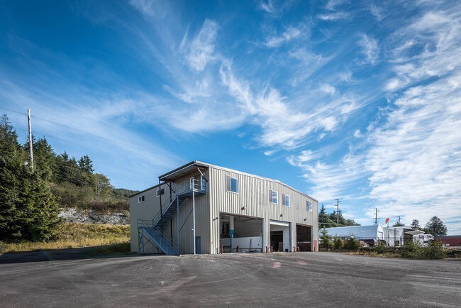
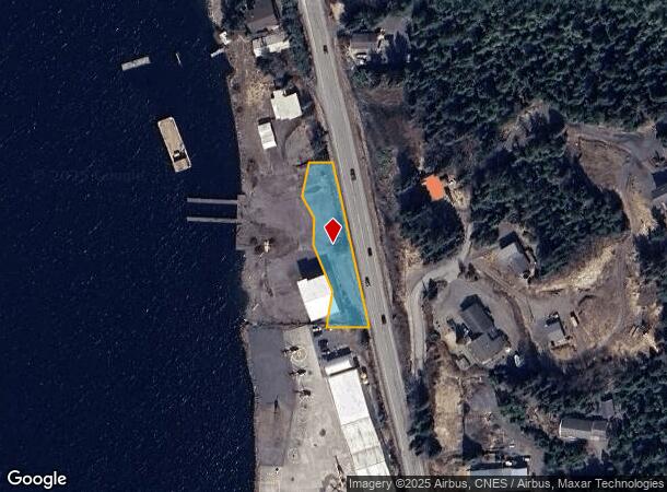
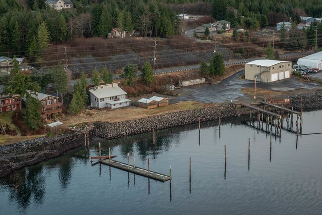
5459 N Tongass Hwy
Ketchikan, AK
City
01-3230-037000
PARCEL NO. 1: LOTS 2, 3, AND 4, RESUBDIVISION OF A PORTION OF U.S. SURVEY 1417, ACCORDING TO THE PLAT THEREOF FILED MARCH 4, 1982 AS PLAT NO. 82-18, KETCHIKAN RECORDING DISTRICT, FIRST JUDICIAL DISTRICT, STATE OF ALASKA. PARCEL NO. 2: TRACT A, SUBDIV
Multipleuses
Ketchikan Gateway
AE
Alaska
02130C0064C
3
2025
0.52 AC
2025
Alaska Regional
000200
Other Market Areas
9,600 SF
DEMOGRAPHICS near 5459 N Tongass Hwy
1 Mile
3 Mile
5 Mile
2024 Total Population
196
3,696
9,765
2029 Population
192
3,639
9,646
Pop Growth 2024-2029
(2.04%)
(1.54%)
(1.22%)
Average Age
43
41
40
2024 Total Households
84
1,403
3,859
HH Growth 2024-2029
(2.38%)
(1.64%)
(1.27%)
Median Household Inc
$59,999
$76,435
$69,586
Avg Household Size
2.30
2.50
2.40
2024 Avg HH Vehicles
2.00
2.00
2.00
Median Home Value
$336,363
$331,162
$323,679
Median Year Built
1981
1978
1973
Nearby Places
Map Layers
Map Styles
 Street
 Aerial
- Restaurants
- Banks
- Shops
- Fitness
- Groceries
PUBLIC TRANSPORTATION
AIRPORT
Ketchikan International
DRIVE
WALK
Distance
Ketchikan International
13 min
3.0 mi
Freight Ports
Vancouver
DRIVE
WALK
Distance
Vancouver
1,578 min
1,060.8 mi
SALE & LEASE HISTORY
LISTING DATE
SALE/LEASE

Oct 04, 2018
For Sale
Nearby Properties
Address
Land Use
TOTAL SIZE
Lot Size
Zoning
Address
Land Use
TOTAL SIZE
Lot Size
Zoning
75,380 SF
17.19 AC
Address
Land Use
TOTAL SIZE
Lot Size
Zoning
211,553 SF
5.13 AC
PLI
Address
Land Use
TOTAL SIZE
Lot Size
Zoning
49,820 SF
7.07 AC
IH
Address
Land Use
TOTAL SIZE
Lot Size
Zoning
31,693 SF
997 AC
FD
Address
Land Use
TOTAL SIZE
Lot Size
Zoning
4,016 SF
37.02 AC
Address
Land Use
TOTAL SIZE
Lot Size
Zoning
163.44 AC
CG
Address
Land Use
TOTAL SIZE
Lot Size
Zoning
82,153 SF
2.50 AC
CG
Address
Land Use
TOTAL SIZE
Lot Size
Zoning
34,113 SF
1.49 AC
PLI
Address
Land Use
TOTAL SIZE
Lot Size
Zoning
70,994 SF
6.36 AC
IL
Address
Land Use
TOTAL SIZE
Lot Size
Zoning
461.86 AC
AD
Address
Land Use
TOTAL SIZE
Lot Size
Zoning
94,500 SF
7.27 AC
PLI
Address
Land Use
TOTAL SIZE
Lot Size
Zoning
35,490 SF
0.89 AC
CG
Address
Land Use
TOTAL SIZE
Lot Size
Zoning
297.30 AC
FD
Address
Land Use
TOTAL SIZE
Lot Size
Zoning
10,142 SF
11.59 AC
IH
Address
Land Use
TOTAL SIZE
Lot Size
Zoning
48,406 SF
1.83 AC
IH
Address
Land Use
TOTAL SIZE
Lot Size
Zoning
12,000 SF
6.25 AC
IH
Address
Land Use
TOTAL SIZE
Lot Size
Zoning
14,180 SF
5.36 AC
IH
Address
Land Use
TOTAL SIZE
Lot Size
Zoning
34,004 SF
0.76 AC
CG
Address
Land Use
TOTAL SIZE
Lot Size
Zoning
83,016 SF
2.95 AC
CG
Address
Land Use
TOTAL SIZE
Lot Size
Zoning
28,731 SF
1.83 AC
CG
Address
Land Use
TOTAL SIZE
Lot Size
Zoning
7,728 SF
5.74 AC
IH
Address
Land Use
TOTAL SIZE
Lot Size
Zoning
70,832 SF
33.29 AC
IH
Address
Land Use
TOTAL SIZE
Lot Size
Zoning
74,454 SF
194.04 AC
IH
Address
Land Use
TOTAL SIZE
Lot Size
Zoning
8,044 SF
2.75 AC
IL
Address
Land Use
TOTAL SIZE
Lot Size
Zoning
71,170 SF
15.55 AC
IH
Address
Land Use
TOTAL SIZE
Lot Size
Zoning
153,130 SF
Address
Land Use
TOTAL SIZE
Lot Size
Zoning
12,838 SF
1.19 AC
PLI
Address
Land Use
TOTAL SIZE
Lot Size
Zoning
30,744 SF
2.13 AC
RH
Address
Land Use
TOTAL SIZE
Lot Size
Zoning
14,338 SF
0.71 AC
CG
Address
Land Use
TOTAL SIZE
Lot Size
Zoning
22,300 SF
6.05 AC
IH
The World's #1 Commercial Real Estate Marketplace
Connect with us
© 2025 CoStar Group
The information above has been obtained from sources believed reliable. While we do not doubt its accuracy we have not verified it and make no guarantee, warranty or representation about it. It is your responsibility to independently confirm its accuracy and completeness. Any projections, opinions, assumptions, or estimates used are for example only and do not represent the current or future performance of the property. The value of this transaction to you depends on tax and other factors which should be evaluated by your tax, financial, and legal advisors. You and your advisors should conduct a careful, independent investigation of the property to determine to your satisfaction the suitability of the property for your needs.