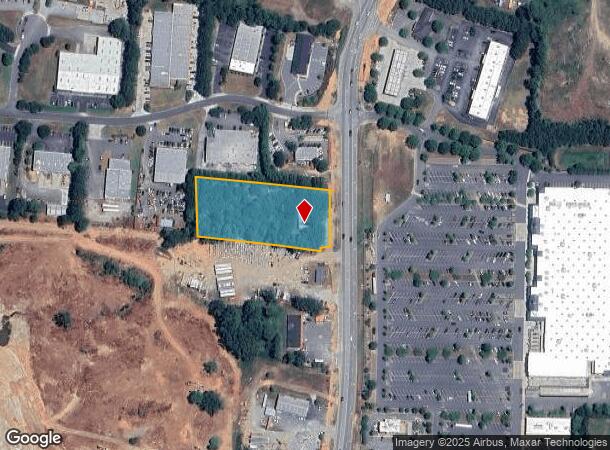
Property Record
5460 Atlanta Hwy, Alpharetta, GA 30004
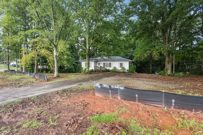
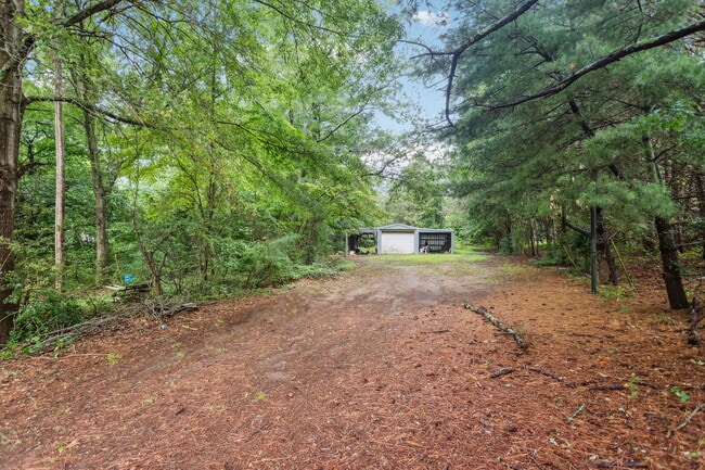
This Property Is For Sale
NEARBY LISTINGS FOR SALE OR LEASE
Property Detail
5460 Atlanta Hwy
Atlanta-Sandy Springs-Roswell, GA
Midway
017-056
Forsyth
Sfr
Georgia
X
1.95 AC
13121C0019G
N Fulton/Forsyth County
1,136 SF
Atlanta
DEMOGRAPHICS near 5460 Atlanta Hwy
1 Mile
3 Mile
5 Mile
2024 Total Population
2,884
36,937
116,189
2029 Population
3,223
41,319
129,251
Pop Growth 2024-2029
+ 11.75%
+ 11.86%
+ 11.24%
Average Age
37
37
38
2024 Total Households
927
11,915
39,842
HH Growth 2024-2029
+ 12.19%
+ 12.03%
+ 11.11%
Median Household Inc
$156,481
$144,606
$133,783
Avg Household Size
3.10
3.00
2.90
2024 Avg HH Vehicles
2.00
2.00
2.00
Median Home Value
$611,888
$483,275
$484,808
Median Year Built
2003
2002
2003
Nearby Places
- Restaurants
- Banks
- Shops
- Fitness
- Groceries
Nearby Properties
Address
Land Use
TOTAL SIZE
Lot Size
Zoning
Address
Land Use
TOTAL SIZE
Lot Size
Zoning
10,908 SF
107.57 AC
RES3
Address
Land Use
TOTAL SIZE
Lot Size
Zoning
90,671 SF
11.03 AC
MP
Address
Land Use
TOTAL SIZE
Lot Size
Zoning
119,926 SF
23.23 AC
M1
Address
Land Use
TOTAL SIZE
Lot Size
Zoning
64.48 AC
AG1
Address
Land Use
TOTAL SIZE
Lot Size
Zoning
83,161 SF
277.43 AC
A1
Address
Land Use
TOTAL SIZE
Lot Size
Zoning
207,663 SF
60.62 AC
R2R
Address
Land Use
TOTAL SIZE
Lot Size
Zoning
96,999 SF
10.93 AC
CBD
Address
Land Use
TOTAL SIZE
Lot Size
Zoning
293,211 SF
16.18 AC
M1
Address
Land Use
TOTAL SIZE
Lot Size
Zoning
130,155 SF
17.10 AC
M1
Address
Land Use
TOTAL SIZE
Lot Size
Zoning
198,235 SF
14.60 AC
M1
Address
Land Use
TOTAL SIZE
Lot Size
Zoning
95,950 SF
14 AC
M1
Address
Land Use
TOTAL SIZE
Lot Size
Zoning
73,120 SF
1.22 AC
AG1
Address
Land Use
TOTAL SIZE
Lot Size
Zoning
6.97 AC
M1
Address
Land Use
TOTAL SIZE
Lot Size
Zoning
121,176 SF
5.86 AC
M1
Address
Land Use
TOTAL SIZE
Lot Size
Zoning
111,102 SF
9.06 AC
M1
Address
Land Use
TOTAL SIZE
Lot Size
Zoning
138,941 SF
26.40 AC
RES3
Address
Land Use
TOTAL SIZE
Lot Size
Zoning
112,810 SF
12.41 AC
M1
Address
Land Use
TOTAL SIZE
Lot Size
Zoning
82,035 SF
12.32 AC
C1
Address
Land Use
TOTAL SIZE
Lot Size
Zoning
151,980 SF
8.77 AC
M1
Address
Land Use
TOTAL SIZE
Lot Size
Zoning
6,298 SF
87.14 AC
A1
Address
Land Use
TOTAL SIZE
Lot Size
Zoning
124,700 SF
9.67 AC
M1
Address
Land Use
TOTAL SIZE
Lot Size
Zoning
181,540 SF
9.62 AC
M1
Address
Land Use
TOTAL SIZE
Lot Size
Zoning
4,800 SF
28.71 AC
M1
Address
Land Use
TOTAL SIZE
Lot Size
Zoning
217,056 SF
24.55 AC
CBD
Address
Land Use
TOTAL SIZE
Lot Size
Zoning
97,820 SF
8.39 AC
M1
Address
Land Use
TOTAL SIZE
Lot Size
Zoning
63,261 SF
17.12 AC
AG1
Address
Land Use
TOTAL SIZE
Lot Size
Zoning
52,173 SF
2.99 AC
CBD
Address
Land Use
TOTAL SIZE
Lot Size
Zoning
116,648 SF
16.50 AC
M1
Address
Land Use
TOTAL SIZE
Lot Size
Zoning
24,931 SF
48.80 AC
CUP
Address
Land Use
TOTAL SIZE
Lot Size
Zoning
101,808 SF
2 AC
CBD
The World's #1 Commercial Real Estate Marketplace
Connect with us
© 2025 CoStar Group
The information above has been obtained from sources believed reliable. While we do not doubt its accuracy we have not verified it and make no guarantee, warranty or representation about it. It is your responsibility to independently confirm its accuracy and completeness. Any projections, opinions, assumptions, or estimates used are for example only and do not represent the current or future performance of the property. The value of this transaction to you depends on tax and other factors which should be evaluated by your tax, financial, and legal advisors. You and your advisors should conduct a careful, independent investigation of the property to determine to your satisfaction the suitability of the property for your needs.