Property Record
5461 Urbana Pike, Frederick, MD 21704
NEARBY LISTINGS FOR SALE OR LEASE
Property Detail
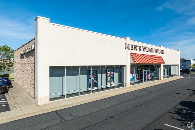
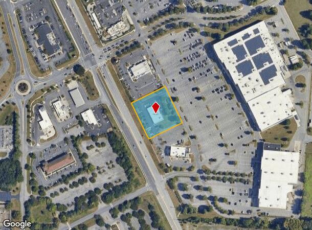
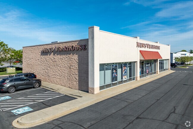
5461 Urbana Pike
Washington-Arlington-Alexandria, DC-VA-MD-WV
Riverview Plaza
28-583923
LOT 2D 52620 SF RIVERVIEW PLAZA
Storebuilding
Frederick
X
Maryland
24021C0294E
2d
2024
1.21 AC
2025
Frederick
751003
Washington, DC
6,300 SF
DEMOGRAPHICS near 5461 Urbana Pike
1 Mile
3 Mile
5 Mile
2024 Total Population
92
50,390
132,798
2029 Population
104
57,449
151,224
Pop Growth 2024-2029
+ 13.04%
+ 14.01%
+ 13.88%
Average Age
43
38
37
2024 Total Households
38
19,966
49,178
HH Growth 2024-2029
+ 13.16%
+ 14.37%
+ 14.33%
Median Household Inc
$84,375
$88,210
$94,406
Avg Household Size
2.20
2.40
2.60
2024 Avg HH Vehicles
2.00
2.00
2.00
Median Home Value
$330,000
$344,874
$368,445
Median Year Built
1985
1990
1993
Nearby Places
Map Layers
Map Styles
 Street
 Aerial
- Restaurants
- Banks
- Shops
- Fitness
- Groceries
PUBLIC TRANSPORTATION
COMMUTER RAIL
DRIVE
WALK
Distance
2 min
9 min
0.4 mi
DRIVE
WALK
Distance
2 min
9 min
0.5 mi
AIRPORT
Hagerstown Regional/Richard A Henson Field
DRIVE
WALK
Distance
Hagerstown Regional/Richard A Henson Field
45 min
32.1 mi
Washington Dulles International
DRIVE
WALK
Distance
Washington Dulles International
69 min
44.0 mi
Freight Ports
Port of Baltimore
DRIVE
WALK
Distance
Port of Baltimore
63 min
50.0 mi
Nearby Properties
Address
Land Use
TOTAL SIZE
Lot Size
Zoning
Address
Land Use
TOTAL SIZE
Lot Size
Zoning
1,368,786 SF
15.79 AC
IST
Address
Land Use
TOTAL SIZE
Lot Size
Zoning
551,652 SF
27.47 AC
M1
Address
Land Use
TOTAL SIZE
Lot Size
Zoning
167,328 SF
617.27 AC
IST
Address
Land Use
TOTAL SIZE
Lot Size
Zoning
747,653 SF
57.55 AC
LI
Address
Land Use
TOTAL SIZE
Lot Size
Zoning
407,190 SF
43.36 AC
IST
Address
Land Use
TOTAL SIZE
Lot Size
Zoning
668,533 SF
45.39 AC
MXD
Address
Land Use
TOTAL SIZE
Lot Size
Zoning
372,920 SF
15.54 AC
PUD
Address
Land Use
TOTAL SIZE
Lot Size
Zoning
458,419 SF
25.94 AC
IST
Address
Land Use
TOTAL SIZE
Lot Size
Zoning
719,578 SF
48.06 AC
GC
Address
Land Use
TOTAL SIZE
Lot Size
Zoning
196,471 SF
7.49 AC
Address
Land Use
TOTAL SIZE
Lot Size
Zoning
459,536 SF
65.48 AC
LI
Address
Land Use
TOTAL SIZE
Lot Size
Zoning
398,032 SF
14.68 AC
MU1
Address
Land Use
TOTAL SIZE
Lot Size
Zoning
252,725 SF
46.49 AC
IE
Address
Land Use
TOTAL SIZE
Lot Size
Zoning
221,825 SF
0.39 AC
IST
Address
Land Use
TOTAL SIZE
Lot Size
Zoning
281,360 SF
21.16 AC
MXD
Address
Land Use
TOTAL SIZE
Lot Size
Zoning
232,532 SF
11.15 AC
PND
Address
Land Use
TOTAL SIZE
Lot Size
Zoning
134,300 SF
12.62 AC
PUD
Address
Land Use
TOTAL SIZE
Lot Size
Zoning
129,448 SF
19.81 AC
PUD
Address
Land Use
TOTAL SIZE
Lot Size
Zoning
327,022 SF
15.61 AC
PUD
Address
Land Use
TOTAL SIZE
Lot Size
Zoning
82,480 SF
17.84 AC
LI
Address
Land Use
TOTAL SIZE
Lot Size
Zoning
185,639 SF
22.94 AC
ORI
Address
Land Use
TOTAL SIZE
Lot Size
Zoning
378,000 SF
20.28 AC
LI
Address
Land Use
TOTAL SIZE
Lot Size
Zoning
152,684 SF
30.10 AC
A
Address
Land Use
TOTAL SIZE
Lot Size
Zoning
277,688 SF
28.05 AC
IST
Address
Land Use
TOTAL SIZE
Lot Size
Zoning
169,802 SF
11.76 AC
PUD
Address
Land Use
TOTAL SIZE
Lot Size
Zoning
228,787 SF
15.63 AC
Address
Land Use
TOTAL SIZE
Lot Size
Zoning
103,258 SF
10.46 AC
MXD
Address
Land Use
TOTAL SIZE
Lot Size
Zoning
108,999 SF
10.73 AC
IST
Address
Land Use
TOTAL SIZE
Lot Size
Zoning
170,940 SF
10.02 AC
LI
Address
Land Use
TOTAL SIZE
Lot Size
Zoning
211,811 SF
13.02 AC
MXD
The World's #1 Commercial Real Estate Marketplace
Connect with us
© 2025 CoStar Group
The information above has been obtained from sources believed reliable. While we do not doubt its accuracy we have not verified it and make no guarantee, warranty or representation about it. It is your responsibility to independently confirm its accuracy and completeness. Any projections, opinions, assumptions, or estimates used are for example only and do not represent the current or future performance of the property. The value of this transaction to you depends on tax and other factors which should be evaluated by your tax, financial, and legal advisors. You and your advisors should conduct a careful, independent investigation of the property to determine to your satisfaction the suitability of the property for your needs.