Property Record
5465 Nc Highway 73 W, Mount Gilead, NC 27306
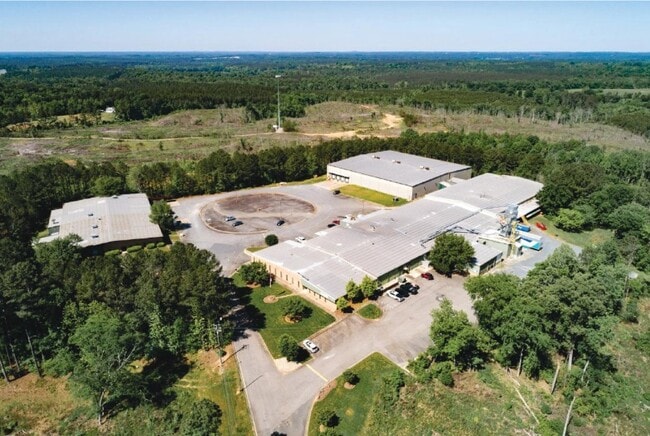
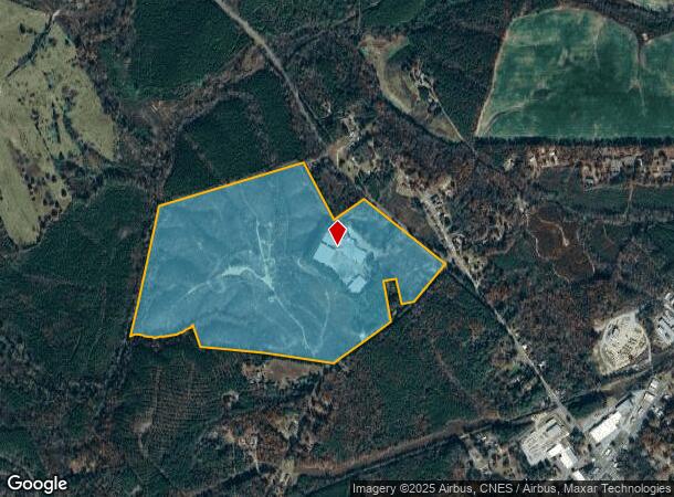
This Property Is For Sale
NEARBY LISTINGS FOR SALE OR LEASE
-
-
View all Mount Gilead listings for sale on LoopNet.com
Property Detail
5465 Nc Highway 73 W
Other Market Areas
Montgomery
6593-07-68-2246
North Carolina
Residentialnec
87.46 AC
AE
North Carolina Southeast Area
3710659300J
DEMOGRAPHICS near 5465 Nc Highway 73 W
1 Mile
3 Mile
5 Mile
2024 Total Population
516
1,713
5,870
2029 Population
492
1,680
6,124
Pop Growth 2024-2029
(4.65%)
(1.93%)
+ 4.33%
Average Age
42
43
45
2024 Total Households
205
681
2,471
HH Growth 2024-2029
(4.88%)
(2.20%)
+ 4.21%
Median Household Inc
$46,184
$46,695
$54,093
Avg Household Size
2.50
2.50
2.30
2024 Avg HH Vehicles
2.00
2.00
2.00
Median Home Value
$106,364
$118,182
$171,759
Median Year Built
1973
1975
1981
Nearby Places
Map Layers
Map Styles
 Street
 Aerial
- Restaurants
- Banks
- Shops
- Fitness
- Groceries
Nearby Properties
Address
Land Use
TOTAL SIZE
Lot Size
Zoning
Address
Land Use
TOTAL SIZE
Lot Size
Zoning
230,550 SF
68.91 AC
INDUSTRIAL
Address
Land Use
TOTAL SIZE
Lot Size
Zoning
116,496 SF
99.46 AC
Address
Land Use
TOTAL SIZE
Lot Size
Zoning
44,501 SF
12.08 AC
SCHOOL
Address
Land Use
TOTAL SIZE
Lot Size
Zoning
55,440 SF
14.74 AC
WAREHOUSE
Address
Land Use
TOTAL SIZE
Lot Size
Zoning
12,704 SF
1.88 AC
Address
Land Use
TOTAL SIZE
Lot Size
Zoning
16,362 SF
4.57 AC
CHURCH
Address
Land Use
TOTAL SIZE
Lot Size
Zoning
6,000 SF
1.11 AC
CHURCH
Address
Land Use
TOTAL SIZE
Lot Size
Zoning
8,260 SF
5.33 AC
CHURCH
Address
Land Use
TOTAL SIZE
Lot Size
Zoning
8,751 SF
12.85 AC
SCHOOL
Address
Land Use
TOTAL SIZE
Lot Size
Zoning
9,790 SF
22.18 AC
Address
Land Use
TOTAL SIZE
Lot Size
Zoning
4,700 SF
2.50 AC
APARTMENTS
Address
Land Use
TOTAL SIZE
Lot Size
Zoning
8,000 SF
1.15 AC
Address
Land Use
TOTAL SIZE
Lot Size
Zoning
55,208 SF
4.70 AC
INDUSTRIAL
Address
Land Use
TOTAL SIZE
Lot Size
Zoning
4,486 SF
0.72 AC
Address
Land Use
TOTAL SIZE
Lot Size
Zoning
14,450 SF
3.87 AC
SKILLED NU
Address
Land Use
TOTAL SIZE
Lot Size
Zoning
1,938 SF
2.50 AC
APARTMENTS
Address
Land Use
TOTAL SIZE
Lot Size
Zoning
3,674 SF
2.02 AC
MEDICAL OF
Address
Land Use
TOTAL SIZE
Lot Size
Zoning
28,000 SF
11.67 AC
INDUSTRIAL
Address
Land Use
TOTAL SIZE
Lot Size
Zoning
47,823 SF
2.71 AC
INDUSTRIAL
Address
Land Use
TOTAL SIZE
Lot Size
Zoning
1,581 SF
12.54 AC
CLUBHOUSE
Address
Land Use
TOTAL SIZE
Lot Size
Zoning
8,064 SF
1.08 AC
CHURCH
Address
Land Use
TOTAL SIZE
Lot Size
Zoning
12,317 SF
4.60 AC
Address
Land Use
TOTAL SIZE
Lot Size
Zoning
2,880 SF
0.22 AC
Address
Land Use
TOTAL SIZE
Lot Size
Zoning
4,652 SF
2.84 AC
Address
Land Use
TOTAL SIZE
Lot Size
Zoning
43,740 SF
2 AC
Address
Land Use
TOTAL SIZE
Lot Size
Zoning
6,595 SF
0.89 AC
FIRE STATI
Address
Land Use
TOTAL SIZE
Lot Size
Zoning
104.49 AC
RESIDENTIA
Address
Land Use
TOTAL SIZE
Lot Size
Zoning
2,698 SF
1.43 AC
BANK
Address
Land Use
TOTAL SIZE
Lot Size
Zoning
12,000 SF
0.75 AC
Address
Land Use
TOTAL SIZE
Lot Size
Zoning
2,400 SF
2.72 AC
MINI-WAREH
The World's #1 Commercial Real Estate Marketplace
Connect with us
© 2026 CoStar Group
The information above has been obtained from sources believed reliable. While we do not doubt its accuracy we have not verified it and make no guarantee, warranty or representation about it. It is your responsibility to independently confirm its accuracy and completeness. Any projections, opinions, assumptions, or estimates used are for example only and do not represent the current or future performance of the property. The value of this transaction to you depends on tax and other factors which should be evaluated by your tax, financial, and legal advisors. You and your advisors should conduct a careful, independent investigation of the property to determine to your satisfaction the suitability of the property for your needs.