Property Record
5469 S Redwood Rd, Salt Lake City, UT 84123

NEARBY LISTINGS FOR SALE OR LEASE
Property Detail
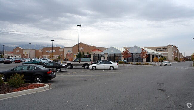
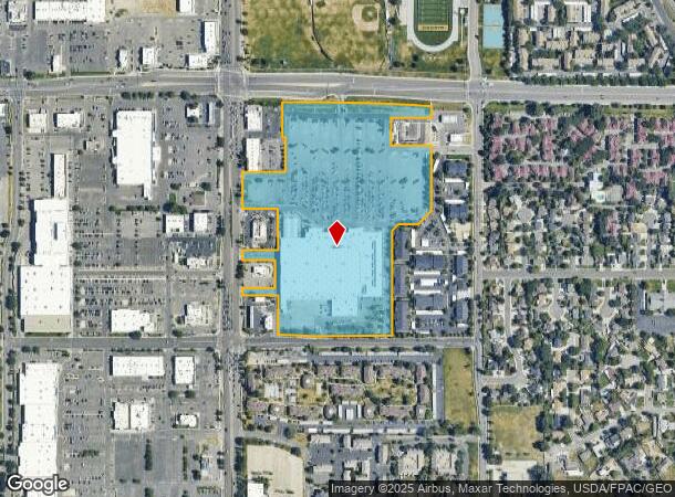
5469 S Redwood Rd
Salt Lake City, UT
Wal-Mart
21-15-201-027-0000
LOT 201, TAYLORSVILLE WAL-MART AMD PLAT 2
Storemultistory
Salt Lake
X
Utah
49035C0293G
201
2023
20.99 AC
2025
Central Valley West
113515
Salt Lake City
227,106 SF
DEMOGRAPHICS near 5469 S Redwood Rd
1 Mile
3 Mile
5 Mile
2024 Total Population
14,817
154,266
417,873
2029 Population
15,105
156,631
422,735
Pop Growth 2024-2029
+ 1.94%
+ 1.53%
+ 1.16%
Average Age
38
37
37
2024 Total Households
5,107
52,585
143,534
HH Growth 2024-2029
+ 1.90%
+ 1.47%
+ 1.13%
Median Household Inc
$76,663
$72,016
$70,643
Avg Household Size
2.80
2.80
2.80
2024 Avg HH Vehicles
2.00
2.00
2.00
Median Home Value
$452,890
$374,433
$369,039
Median Year Built
1986
1984
1982
Nearby Places
Map Layers
Map Styles
 Street
 Aerial
- Restaurants
- Banks
- Shops
- Fitness
- Groceries
PUBLIC TRANSPORTATION
COMMUTER RAIL
South Jordan Station (FrontRunner - Utah Transit Authority (UTA))
DRIVE
WALK
Distance
South Jordan Station (FrontRunner - Utah Transit Authority (UTA))
13 min
9.3 mi
AIRPORT
Salt Lake City International
DRIVE
WALK
Distance
Salt Lake City International
18 min
12.9 mi
Freight Ports
Port of Stockton
DRIVE
WALK
Distance
Port of Stockton
718 min
699.5 mi
Nearby Properties
Address
Land Use
TOTAL SIZE
Lot Size
Zoning
Address
Land Use
TOTAL SIZE
Lot Size
Zoning
2,024,859 SF
63 AC
C D C
Address
Land Use
TOTAL SIZE
Lot Size
Zoning
659,583 SF
18.32 AC
CDC
Address
Land Use
TOTAL SIZE
Lot Size
Zoning
895,175 SF
28.95 AC
SSD-X
Address
Land Use
TOTAL SIZE
Lot Size
Zoning
35,897 SF
28.61 AC
RM-12
Address
Land Use
TOTAL SIZE
Lot Size
Zoning
828,269 SF
9.06 AC
RM
Address
Land Use
TOTAL SIZE
Lot Size
Zoning
251,867 SF
25.66 AC
H
Address
Land Use
TOTAL SIZE
Lot Size
Zoning
521,964 SF
3.23 AC
T-O-D
Address
Land Use
TOTAL SIZE
Lot Size
Zoning
185,436 SF
25.23 AC
RM
Address
Land Use
TOTAL SIZE
Lot Size
Zoning
497,522 SF
16.43 AC
MH
Address
Land Use
TOTAL SIZE
Lot Size
Zoning
382,335 SF
63.87 AC
OS
Address
Land Use
TOTAL SIZE
Lot Size
Zoning
179,702 SF
16.99 AC
1108
Address
Land Use
TOTAL SIZE
Lot Size
Zoning
195,790 SF
14.32 AC
RM
Address
Land Use
TOTAL SIZE
Lot Size
Zoning
448,232 SF
9.08 AC
PC
Address
Land Use
TOTAL SIZE
Lot Size
Zoning
74,120 SF
12.61 AC
BJ
Address
Land Use
TOTAL SIZE
Lot Size
Zoning
123,864 SF
6.75 AC
C-2
Address
Land Use
TOTAL SIZE
Lot Size
Zoning
178,102 SF
15.95 AC
C-3
Address
Land Use
TOTAL SIZE
Lot Size
Zoning
321,397 SF
11.16 AC
BJ
Address
Land Use
TOTAL SIZE
Lot Size
Zoning
84,870 SF
9.76 AC
MPMU
Address
Land Use
TOTAL SIZE
Lot Size
Zoning
45,924 SF
18.15 AC
R-3-20
Address
Land Use
TOTAL SIZE
Lot Size
Zoning
289,838 SF
24.11 AC
BJ-3
Address
Land Use
TOTAL SIZE
Lot Size
Zoning
441,275 SF
2.62 AC
M-U
Address
Land Use
TOTAL SIZE
Lot Size
Zoning
117,521 SF
57.92 AC
PF
Address
Land Use
TOTAL SIZE
Lot Size
Zoning
401,887 SF
3.51 AC
RM
Address
Land Use
TOTAL SIZE
Lot Size
Zoning
63,758 SF
13.93 AC
RM
Address
Land Use
TOTAL SIZE
Lot Size
Zoning
138,180 SF
2.06 AC
RM-12
Address
Land Use
TOTAL SIZE
Lot Size
Zoning
80,985 SF
19.18 AC
RM
Address
Land Use
TOTAL SIZE
Lot Size
Zoning
97,360 SF
10.43 AC
RM-25
Address
Land Use
TOTAL SIZE
Lot Size
Zoning
89,239 SF
14.78 AC
RM
Address
Land Use
TOTAL SIZE
Lot Size
Zoning
114,519 SF
17.34 AC
RM-25
Address
Land Use
TOTAL SIZE
Lot Size
Zoning
126,900 SF
0.38 AC
1108
The World's #1 Commercial Real Estate Marketplace
Connect with us
© 2025 CoStar Group
The information above has been obtained from sources believed reliable. While we do not doubt its accuracy we have not verified it and make no guarantee, warranty or representation about it. It is your responsibility to independently confirm its accuracy and completeness. Any projections, opinions, assumptions, or estimates used are for example only and do not represent the current or future performance of the property. The value of this transaction to you depends on tax and other factors which should be evaluated by your tax, financial, and legal advisors. You and your advisors should conduct a careful, independent investigation of the property to determine to your satisfaction the suitability of the property for your needs.