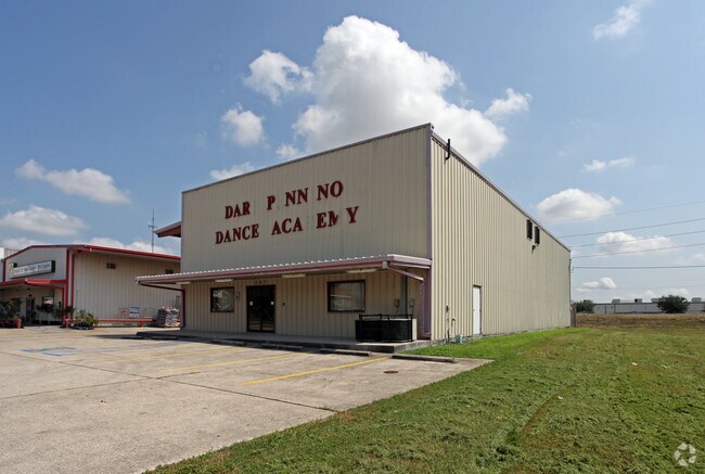
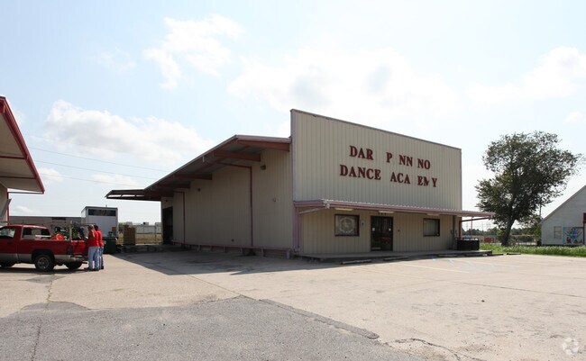
Property Record
547 Holmes Blvd, Gretna, LA 70056

NEARBY LISTINGS FOR SALE OR LEASE
Property Detail
547 Holmes Blvd
New Orleans-Metairie, LA
Terrytown
0200009863
LOT 4A3 SEC 8 TERRYTOWN
Realpropertynec
Jefferson
AE
Louisiana
22051C0220F
4a3
2024
0.30 AC
2024
Westbank
025005
New Orleans/Metairie/Kenner
DEMOGRAPHICS near 547 Holmes Blvd
1 mile
3 mile
5 mile
2024 Total Population
16,898
100,534
249,883
2029 Population
16,150
96,285
243,145
Pop Growth 2024-2029
(4.43%)
(4.23%)
(2.70%)
Average Age
39
39
40
2024 Total Households
6,399
38,633
107,290
HH Growth 2024-2029
(4.78%)
(4.40%)
(2.63%)
Median Household Inc
$48,591
$44,698
$51,604
Avg Household Size
2.50
2.50
2.20
2024 Avg HH Vehicles
2.00
1.00
1.00
Median Home Value
$171,874
$190,396
$225,654
Median Year Built
1974
1973
1967
Nearby Places
Map Layers
Map Styles
 Street
 Aerial
Transit
 Traffic
 Biking
Places
Listings with unknown addresses are not visible on the map
- Restaurants
- Banks
- Shops
- Fitness
- Groceries
PUBLIC TRANSPORTATION
COMMUTER RAIL
Drive
Walk
Distance
10 min
5.2 mi
AIRPORT
Louis Armstrong New Orleans International
Drive
Walk
Distance
Louis Armstrong New Orleans International
29 min
19.5 mi
Freight Ports
Plaquemines Port
Drive
Walk
Distance
Plaquemines Port
8 min
4.7 mi
Nearby Properties
Address
Land Use
TOTAL SIZE
Lot Size
Zoning
Address
Land Use
TOTAL SIZE
Lot Size
Zoning
0.12 AC
Address
Land Use
TOTAL SIZE
Lot Size
Zoning
30.63 AC
Address
Land Use
TOTAL SIZE
Lot Size
Zoning
202,291 SF
4.04 AC
HU-RD2
Address
Land Use
TOTAL SIZE
Lot Size
Zoning
4.12 AC
Address
Land Use
TOTAL SIZE
Lot Size
Zoning
25.26 AC
Address
Land Use
TOTAL SIZE
Lot Size
Zoning
85,568 SF
23.74 AC
MU-1
Address
Land Use
TOTAL SIZE
Lot Size
Zoning
109,688 SF
8.77 AC
S-RM1
Address
Land Use
TOTAL SIZE
Lot Size
Zoning
23.90 AC
Address
Land Use
TOTAL SIZE
Lot Size
Zoning
0.23 AC
Address
Land Use
TOTAL SIZE
Lot Size
Zoning
14.40 AC
Address
Land Use
TOTAL SIZE
Lot Size
Zoning
140,772 SF
9.01 AC
S-RS
Address
Land Use
TOTAL SIZE
Lot Size
Zoning
3.55 AC
Address
Land Use
TOTAL SIZE
Lot Size
Zoning
12.79 AC
Address
Land Use
TOTAL SIZE
Lot Size
Zoning
14.69 AC
Address
Land Use
TOTAL SIZE
Lot Size
Zoning
Address
Land Use
TOTAL SIZE
Lot Size
Zoning
0.19 AC
Address
Land Use
TOTAL SIZE
Lot Size
Zoning
21.96 AC
MUCD
Address
Land Use
TOTAL SIZE
Lot Size
Zoning
10.14 AC
Address
Land Use
TOTAL SIZE
Lot Size
Zoning
0.78 AC
Address
Land Use
TOTAL SIZE
Lot Size
Zoning
0.14 AC
Address
Land Use
TOTAL SIZE
Lot Size
Zoning
Address
Land Use
TOTAL SIZE
Lot Size
Zoning
2.84 AC
Address
Land Use
TOTAL SIZE
Lot Size
Zoning
10,704 SF
3.67 AC
LI
Address
Land Use
TOTAL SIZE
Lot Size
Zoning
1.38 AC
Address
Land Use
TOTAL SIZE
Lot Size
Zoning
147,253 SF
9.95 AC
S-RM1
Address
Land Use
TOTAL SIZE
Lot Size
Zoning
Address
Land Use
TOTAL SIZE
Lot Size
Zoning
16.84 AC
EC
Address
Land Use
TOTAL SIZE
Lot Size
Zoning
228,859 SF
23.59 AC
C-3
Address
Land Use
TOTAL SIZE
Lot Size
Zoning
42.23 AC
Address
Land Use
TOTAL SIZE
Lot Size
Zoning
8.11 AC
EC
The World's #1 Commercial Real Estate Marketplace
Connect with us
© 2026 CoStar Group
The information above has been obtained from sources believed reliable. While we do not doubt its accuracy we have not verified it and make no guarantee, warranty or representation about it. It is your responsibility to independently confirm its accuracy and completeness. Any projections, opinions, assumptions, or estimates used are for example only and do not represent the current or future performance of the property. The value of this transaction to you depends on tax and other factors which should be evaluated by your tax, financial, and legal advisors. You and your advisors should conduct a careful, independent investigation of the property to determine to your satisfaction the suitability of the property for your needs.