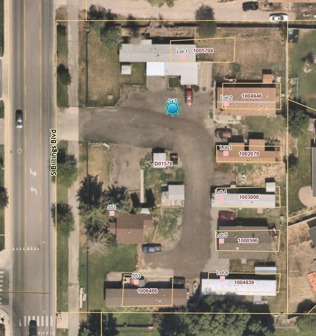
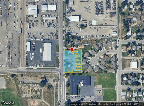
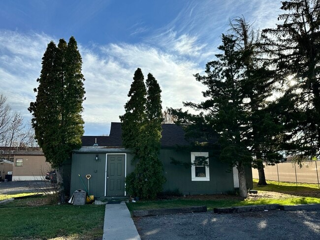
Property Record
547 S Billings Blvd, Billings, MT 59101
This Property Is For Sale
NEARBY LISTINGS FOR SALE OR LEASE
-
-
View all Billings listings for sale on LoopNet.com
Property Detail
547 S Billings Blvd
Billings, MT
Cert /Surv 3128 Tr #1
03-0927-09-3-10-12-0000
S09, T01 S, R26 E, C.O.S. 3128, PARCEL 1
Multifamilydwelling
Yellowstone
X
Montana
30111C1270E
5
2024
1.29 AC
2025
Billings
000902
Other Market Areas
696 SF
DEMOGRAPHICS near 547 S Billings Blvd
1 Mile
3 Mile
5 Mile
2024 Total Population
7,880
61,358
103,612
2029 Population
8,545
66,339
112,256
Pop Growth 2024-2029
+ 8.44%
+ 8.12%
+ 8.34%
Average Age
37
40
40
2024 Total Households
3,280
26,840
44,521
HH Growth 2024-2029
+ 8.54%
+ 8.29%
+ 8.52%
Median Household Inc
$44,374
$59,473
$65,763
Avg Household Size
2.30
2.10
2.20
2024 Avg HH Vehicles
2.00
2.00
2.00
Median Home Value
$190,827
$258,881
$282,122
Median Year Built
1969
1964
1976
Nearby Places
- Restaurants
- Banks
- Shops
- Fitness
- Groceries
PUBLIC TRANSPORTATION
AIRPORT
Billings Logan International
DRIVE
WALK
Distance
Billings Logan International
24 min
7.9 mi
Freight Ports
Port of Everett
DRIVE
WALK
Distance
Port of Everett
880 min
839.4 mi
Nearby Properties
Address
Land Use
TOTAL SIZE
Lot Size
Zoning
Address
Land Use
TOTAL SIZE
Lot Size
Zoning
650,098 SF
53.35 AC
CI
Address
Land Use
TOTAL SIZE
Lot Size
Zoning
704,701 SF
9.06 AC
MCPZD
Address
Land Use
TOTAL SIZE
Lot Size
Zoning
615,777 SF
5.85 AC
MCPZD
Address
Land Use
TOTAL SIZE
Lot Size
Zoning
483,842 SF
55.14 AC
P
Address
Land Use
TOTAL SIZE
Lot Size
Zoning
198,096 SF
7.48 AC
MCPZD
Address
Land Use
TOTAL SIZE
Lot Size
Zoning
295,400 SF
17 AC
Address
Land Use
TOTAL SIZE
Lot Size
Zoning
9.37 AC
P
Address
Land Use
TOTAL SIZE
Lot Size
Zoning
136,588 SF
21.01 AC
CI
Address
Land Use
TOTAL SIZE
Lot Size
Zoning
258,977 SF
18.05 AC
CI
Address
Land Use
TOTAL SIZE
Lot Size
Zoning
116,250 SF
9.39 AC
Address
Land Use
TOTAL SIZE
Lot Size
Zoning
213,615 SF
0.96 AC
CBD
Address
Land Use
TOTAL SIZE
Lot Size
Zoning
76,098 SF
0.80 AC
CBD
Address
Land Use
TOTAL SIZE
Lot Size
Zoning
537,468 SF
36.83 AC
CC
Address
Land Use
TOTAL SIZE
Lot Size
Zoning
108,000 SF
2.07 AC
CBD
Address
Land Use
TOTAL SIZE
Lot Size
Zoning
145,168 SF
0.96 AC
CBD
Address
Land Use
TOTAL SIZE
Lot Size
Zoning
218,478 SF
18.19 AC
CI
Address
Land Use
TOTAL SIZE
Lot Size
Zoning
109,714 SF
NC
Address
Land Use
TOTAL SIZE
Lot Size
Zoning
172.22 AC
Address
Land Use
TOTAL SIZE
Lot Size
Zoning
71,600 SF
0.15 AC
CBD
Address
Land Use
TOTAL SIZE
Lot Size
Zoning
177,290 SF
14.59 AC
HC
Address
Land Use
TOTAL SIZE
Lot Size
Zoning
188,907 SF
3.83 AC
CC
Address
Land Use
TOTAL SIZE
Lot Size
Zoning
149,797 SF
12.95 AC
CC
Address
Land Use
TOTAL SIZE
Lot Size
Zoning
234,444 SF
4.98 AC
MCPZD
Address
Land Use
TOTAL SIZE
Lot Size
Zoning
26.09 AC
Address
Land Use
TOTAL SIZE
Lot Size
Zoning
63,650 SF
4.13 AC
MCPZD
Address
Land Use
TOTAL SIZE
Lot Size
Zoning
118,640 SF
12.55 AC
P
Address
Land Use
TOTAL SIZE
Lot Size
Zoning
1,200 SF
57.17 AC
P
Address
Land Use
TOTAL SIZE
Lot Size
Zoning
409,620 SF
27.42 AC
CI
Address
Land Use
TOTAL SIZE
Lot Size
Zoning
135,273 SF
3.76 AC
R-60
Address
Land Use
TOTAL SIZE
Lot Size
Zoning
141,186 SF
2.62 AC
CBD
The World's #1 Commercial Real Estate Marketplace
Connect with us
© 2025 CoStar Group
The information above has been obtained from sources believed reliable. While we do not doubt its accuracy we have not verified it and make no guarantee, warranty or representation about it. It is your responsibility to independently confirm its accuracy and completeness. Any projections, opinions, assumptions, or estimates used are for example only and do not represent the current or future performance of the property. The value of this transaction to you depends on tax and other factors which should be evaluated by your tax, financial, and legal advisors. You and your advisors should conduct a careful, independent investigation of the property to determine to your satisfaction the suitability of the property for your needs.