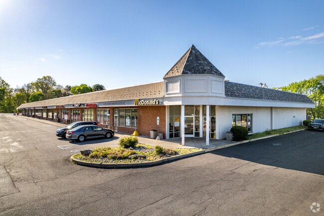
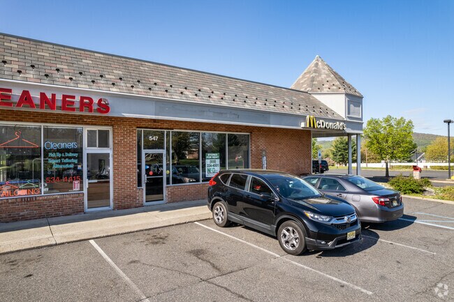
Property Record
547 Us Highway 22, Lebanon, NJ 08833
NEARBY LISTINGS FOR SALE OR LEASE
Property Detail
547 Us Highway 22
22-00035-0000-00025
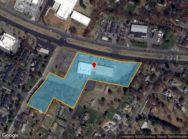
Map Showing Layout Of Maple Park
Storebuilding
Hunterdon
X
New Jersey
34019C0257F
25
2024
6.11 AC
2025
Route 78 West
010802
Northern New Jersey
28,410 SF
Newark, NJ
DEMOGRAPHICS near 547 Us Highway 22
1 Mile
3 Mile
5 Mile
2024 Total Population
3,071
11,001
30,122
2029 Population
3,153
11,161
30,265
Pop Growth 2024-2029
+ 2.67%
+ 1.45%
+ 0.47%
Average Age
48
46
45
2024 Total Households
1,307
4,484
11,654
HH Growth 2024-2029
+ 2.60%
+ 1.43%
+ 0.46%
Median Household Inc
$97,353
$119,743
$139,804
Avg Household Size
2.30
2.40
2.50
2024 Avg HH Vehicles
2.00
2.00
2.00
Median Home Value
$463,621
$476,840
$522,539
Median Year Built
1982
1983
1982
Nearby Places
Map Layers
Map Styles
 Street
 Aerial
- Restaurants
- Banks
- Shops
- Fitness
- Groceries
PUBLIC TRANSPORTATION
COMMUTER RAIL
White House (Raritan Valley Line - NJ Transit Commuter Rail (NJ Transit))
DRIVE
WALK
Distance
White House (Raritan Valley Line - NJ Transit Commuter Rail (NJ Transit))
4 min
1.3 mi
Lebanon (Raritan Valley Line - NJ Transit Commuter Rail (NJ Transit))
DRIVE
WALK
Distance
Lebanon (Raritan Valley Line - NJ Transit Commuter Rail (NJ Transit))
10 min
5.1 mi
AIRPORT
Trenton Mercer
DRIVE
WALK
Distance
Trenton Mercer
59 min
31.1 mi
Freight Ports
New York Container Terminal
DRIVE
WALK
Distance
New York Container Terminal
52 min
40.2 mi
SALE & LEASE HISTORY
LISTING DATE
SALE/LEASE

Sep 25, 2016
For Lease
Apr 23, 2022
For Sale
Nearby Properties
Address
Land Use
TOTAL SIZE
Lot Size
Zoning
Address
Land Use
TOTAL SIZE
Lot Size
Zoning
187,596 SF
54.59 AC
RO
Address
Land Use
TOTAL SIZE
Lot Size
Zoning
61.69 AC
RO
Address
Land Use
TOTAL SIZE
Lot Size
Zoning
8,000 SF
17.12 AC
RO
Address
Land Use
TOTAL SIZE
Lot Size
Zoning
18.46 AC
I
Address
Land Use
TOTAL SIZE
Lot Size
Zoning
14,182 SF
77.17 AC
ROMX
Address
Land Use
TOTAL SIZE
Lot Size
Zoning
118.92 AC
R10
Address
Land Use
TOTAL SIZE
Lot Size
Zoning
20 AC
AR
Address
Land Use
TOTAL SIZE
Lot Size
Zoning
12.05 AC
I-IP
Address
Land Use
TOTAL SIZE
Lot Size
Zoning
25.75 AC
I-1
Address
Land Use
TOTAL SIZE
Lot Size
Zoning
5.98 AC
I-IP
Address
Land Use
TOTAL SIZE
Lot Size
Zoning
22.84 AC
I-1
Address
Land Use
TOTAL SIZE
Lot Size
Zoning
18,288 SF
3.78 AC
I-IP
Address
Land Use
TOTAL SIZE
Lot Size
Zoning
12.83 AC
I-1
Address
Land Use
TOTAL SIZE
Lot Size
Zoning
7.81 AC
I-Z
Address
Land Use
TOTAL SIZE
Lot Size
Zoning
46.18 AC
RR
Address
Land Use
TOTAL SIZE
Lot Size
Zoning
58,471 SF
8.69 AC
B
Address
Land Use
TOTAL SIZE
Lot Size
Zoning
8.40 AC
I&IP
Address
Land Use
TOTAL SIZE
Lot Size
Zoning
20,048 SF
3 AC
AR
Address
Land Use
TOTAL SIZE
Lot Size
Zoning
4.28 AC
I-IP
Address
Land Use
TOTAL SIZE
Lot Size
Zoning
4.90 AC
IP
Address
Land Use
TOTAL SIZE
Lot Size
Zoning
4.69 AC
I-IP
Address
Land Use
TOTAL SIZE
Lot Size
Zoning
4.88 AC
I-1
Address
Land Use
TOTAL SIZE
Lot Size
Zoning
127,961 SF
50 AC
B
Address
Land Use
TOTAL SIZE
Lot Size
Zoning
20,764 SF
21.01 AC
ROM1
Address
Land Use
TOTAL SIZE
Lot Size
Zoning
23.06 AC
I-1
Address
Land Use
TOTAL SIZE
Lot Size
Zoning
3.49 AC
I-IP
Address
Land Use
TOTAL SIZE
Lot Size
Zoning
67,200 SF
4.01 AC
I
Address
Land Use
TOTAL SIZE
Lot Size
Zoning
139 AC
AR
Address
Land Use
TOTAL SIZE
Lot Size
Zoning
6.53 AC
I-IP
Address
Land Use
TOTAL SIZE
Lot Size
Zoning
23.40 AC
RR
The World's #1 Commercial Real Estate Marketplace
Connect with us
© 2026 CoStar Group
The information above has been obtained from sources believed reliable. While we do not doubt its accuracy we have not verified it and make no guarantee, warranty or representation about it. It is your responsibility to independently confirm its accuracy and completeness. Any projections, opinions, assumptions, or estimates used are for example only and do not represent the current or future performance of the property. The value of this transaction to you depends on tax and other factors which should be evaluated by your tax, financial, and legal advisors. You and your advisors should conduct a careful, independent investigation of the property to determine to your satisfaction the suitability of the property for your needs.