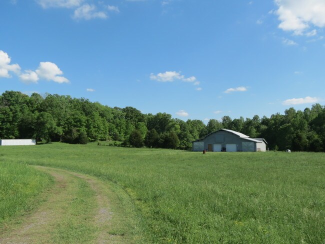
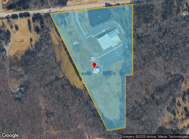
Property Record
5501 Highway 55 E, Clover, SC 29710
NEARBY LISTINGS FOR SALE OR LEASE
Property Detail
5501 Highway 55 E
Charlotte-Concord-Gastonia, NC-SC
Acres
4840000067
LOT 1 ( 16 ACRES )
Vacantlandexempt
York
X
South Carolina
45091C0178E
1
0
16 AC
2025
York County
061706
Charlotte
DEMOGRAPHICS near 5501 Highway 55 E
1 Mile
3 Mile
5 Mile
2024 Total Population
3,813
20,127
47,181
2029 Population
4,373
22,889
53,235
Pop Growth 2024-2029
+ 14.69%
+ 13.72%
+ 12.83%
Average Age
39
41
41
2024 Total Households
1,423
7,739
17,946
HH Growth 2024-2029
+ 15.04%
+ 14.06%
+ 13.17%
Median Household Inc
$90,325
$99,010
$110,504
Avg Household Size
2.60
2.60
2.60
2024 Avg HH Vehicles
2.00
2.00
2.00
Median Home Value
$335,447
$385,149
$407,787
Median Year Built
2010
2006
2006
Nearby Places
Map Layers
Map Styles
 Street
 Aerial
- Restaurants
- Banks
- Shops
- Fitness
- Groceries
PUBLIC TRANSPORTATION
AIRPORT
Charlotte/Douglas International
DRIVE
WALK
Distance
Charlotte/Douglas International
32 min
18.5 mi
Concord-Padgett Regional
DRIVE
WALK
Distance
Concord-Padgett Regional
53 min
40.0 mi
Freight Ports
North Charleston Terminal
DRIVE
WALK
Distance
North Charleston Terminal
219 min
189.4 mi
SALE & LEASE HISTORY
LISTING DATE
SALE/LEASE

Sep 20, 2017
For Sale
Nearby Properties
Address
Land Use
TOTAL SIZE
Lot Size
Zoning
Address
Land Use
TOTAL SIZE
Lot Size
Zoning
551.16 AC
ID
Address
Land Use
TOTAL SIZE
Lot Size
Zoning
21,537 SF
3.32 AC
BDIII
Address
Land Use
TOTAL SIZE
Lot Size
Zoning
38,142 SF
30.01 AC
PD
Address
Land Use
TOTAL SIZE
Lot Size
Zoning
27,372 SF
14.37 AC
RDII
Address
Land Use
TOTAL SIZE
Lot Size
Zoning
14.43 AC
RDI
Address
Land Use
TOTAL SIZE
Lot Size
Zoning
27,600 SF
35.50 AC
RDI
Address
Land Use
TOTAL SIZE
Lot Size
Zoning
7,840 SF
10.44 AC
RDI
Address
Land Use
TOTAL SIZE
Lot Size
Zoning
4.97 AC
BDI
Address
Land Use
TOTAL SIZE
Lot Size
Zoning
44,977 SF
24.59 AC
BDIII
Address
Land Use
TOTAL SIZE
Lot Size
Zoning
8.89 AC
BDIII
Address
Land Use
TOTAL SIZE
Lot Size
Zoning
10.18 AC
Address
Land Use
TOTAL SIZE
Lot Size
Zoning
3.89 AC
BDIII
Address
Land Use
TOTAL SIZE
Lot Size
Zoning
6,103 SF
65.50 AC
RUD
Address
Land Use
TOTAL SIZE
Lot Size
Zoning
8,876 SF
1 AC
RDII
Address
Land Use
TOTAL SIZE
Lot Size
Zoning
3,438 SF
46.81 AC
RCI
Address
Land Use
TOTAL SIZE
Lot Size
Zoning
2.92 AC
BDIII
Address
Land Use
TOTAL SIZE
Lot Size
Zoning
1,730 SF
6.88 AC
RCI
Address
Land Use
TOTAL SIZE
Lot Size
Zoning
3.53 AC
BDIII
Address
Land Use
TOTAL SIZE
Lot Size
Zoning
4,865 SF
1.03 AC
RDII
Address
Land Use
TOTAL SIZE
Lot Size
Zoning
3,816 SF
1.18 AC
Address
Land Use
TOTAL SIZE
Lot Size
Zoning
170.90 AC
PD
Address
Land Use
TOTAL SIZE
Lot Size
Zoning
4,172 SF
1.03 AC
RDII
Address
Land Use
TOTAL SIZE
Lot Size
Zoning
2,772 SF
2 AC
RUD
Address
Land Use
TOTAL SIZE
Lot Size
Zoning
183,578 SF
23.80 AC
BDIII
Address
Land Use
TOTAL SIZE
Lot Size
Zoning
5,176 SF
2.27 AC
RDII
Address
Land Use
TOTAL SIZE
Lot Size
Zoning
2,792 SF
1 AC
RDII
Address
Land Use
TOTAL SIZE
Lot Size
Zoning
4,425 SF
RCI
Address
Land Use
TOTAL SIZE
Lot Size
Zoning
2,917 SF
1 AC
RDII
Address
Land Use
TOTAL SIZE
Lot Size
Zoning
5,572 SF
1 AC
RDI
Address
Land Use
TOTAL SIZE
Lot Size
Zoning
3,502 SF
2.35 AC
The World's #1 Commercial Real Estate Marketplace
Connect with us
© 2025 CoStar Group
The information above has been obtained from sources believed reliable. While we do not doubt its accuracy we have not verified it and make no guarantee, warranty or representation about it. It is your responsibility to independently confirm its accuracy and completeness. Any projections, opinions, assumptions, or estimates used are for example only and do not represent the current or future performance of the property. The value of this transaction to you depends on tax and other factors which should be evaluated by your tax, financial, and legal advisors. You and your advisors should conduct a careful, independent investigation of the property to determine to your satisfaction the suitability of the property for your needs.