Property Record
5475 N State Highway 7, Scipio, IN 47273
NEARBY LISTINGS FOR SALE OR LEASE
-
-
View all Scipio listings for sale on LoopNet.com
Property Detail
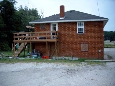
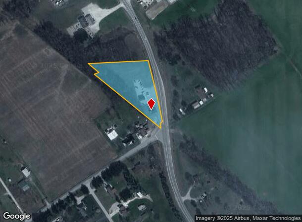
5475 N State Highway 7
40-10-12-300-010.000-006
FRAC SWQ NIBL 12-7-7 1.50 AC ABANDONED RR 12-7-7 .24 AC
Storebuilding
Jennings
X
Indiana
18079C0150C
1.74 AC
2024
Indiana South Area
2024
Other Market Areas
960301
North Vernon, IN
2,446 SF
DEMOGRAPHICS near 5475 N State Highway 7
1 Mile
3 Mile
5 Mile
2024 Total Population
591
6,422
10,354
2029 Population
591
6,545
10,412
Pop Growth 2024-2029
0.00%
+ 1.92%
+ 0.56%
Average Age
39
38
40
2024 Total Households
218
2,320
3,903
HH Growth 2024-2029
0.00%
+ 1.90%
+ 0.46%
Median Household Inc
$59,374
$56,960
$58,716
Avg Household Size
2.70
2.70
2.60
2024 Avg HH Vehicles
2.00
2.00
2.00
Median Home Value
$152,238
$97,626
$113,433
Median Year Built
1992
1990
1988
Nearby Places
Map Layers
Map Styles
 Street
 Aerial
- Restaurants
- Banks
- Shops
- Fitness
- Groceries
Nearby Properties
Address
Land Use
TOTAL SIZE
Lot Size
Zoning
Address
Land Use
TOTAL SIZE
Lot Size
Zoning
8,192 SF
4.35 AC
Address
Land Use
TOTAL SIZE
Lot Size
Zoning
68,905 SF
4.77 AC
Address
Land Use
TOTAL SIZE
Lot Size
Zoning
9,014 SF
2.78 AC
Address
Land Use
TOTAL SIZE
Lot Size
Zoning
250 AC
Address
Land Use
TOTAL SIZE
Lot Size
Zoning
1,320 SF
293.16 AC
Address
Land Use
TOTAL SIZE
Lot Size
Zoning
239.16 AC
Address
Land Use
TOTAL SIZE
Lot Size
Zoning
387.05 AC
Address
Land Use
TOTAL SIZE
Lot Size
Zoning
158.22 AC
Address
Land Use
TOTAL SIZE
Lot Size
Zoning
1,152 SF
94 AC
Address
Land Use
TOTAL SIZE
Lot Size
Zoning
151.23 AC
Address
Land Use
TOTAL SIZE
Lot Size
Zoning
328.09 AC
Address
Land Use
TOTAL SIZE
Lot Size
Zoning
160 AC
Address
Land Use
TOTAL SIZE
Lot Size
Zoning
5,625 SF
1.58 AC
Address
Land Use
TOTAL SIZE
Lot Size
Zoning
7,828 SF
0.90 AC
Address
Land Use
TOTAL SIZE
Lot Size
Zoning
159.94 AC
Address
Land Use
TOTAL SIZE
Lot Size
Zoning
12,300 SF
1.53 AC
Address
Land Use
TOTAL SIZE
Lot Size
Zoning
Address
Land Use
TOTAL SIZE
Lot Size
Zoning
11,879 SF
12.44 AC
Address
Land Use
TOTAL SIZE
Lot Size
Zoning
5,800 SF
0.39 AC
Address
Land Use
TOTAL SIZE
Lot Size
Zoning
114.33 AC
Address
Land Use
TOTAL SIZE
Lot Size
Zoning
4,200 SF
3.71 AC
Address
Land Use
TOTAL SIZE
Lot Size
Zoning
728 SF
97.50 AC
Address
Land Use
TOTAL SIZE
Lot Size
Zoning
11,280 SF
3.40 AC
Address
Land Use
TOTAL SIZE
Lot Size
Zoning
233.43 AC
Address
Land Use
TOTAL SIZE
Lot Size
Zoning
7,400 SF
7.88 AC
Address
Land Use
TOTAL SIZE
Lot Size
Zoning
115.87 AC
Address
Land Use
TOTAL SIZE
Lot Size
Zoning
3,600 SF
11.78 AC
Address
Land Use
TOTAL SIZE
Lot Size
Zoning
144.04 AC
Address
Land Use
TOTAL SIZE
Lot Size
Zoning
6,000 SF
0.90 AC
Address
Land Use
TOTAL SIZE
Lot Size
Zoning
80 AC
The World's #1 Commercial Real Estate Marketplace
Connect with us
© 2025 CoStar Group
The information above has been obtained from sources believed reliable. While we do not doubt its accuracy we have not verified it and make no guarantee, warranty or representation about it. It is your responsibility to independently confirm its accuracy and completeness. Any projections, opinions, assumptions, or estimates used are for example only and do not represent the current or future performance of the property. The value of this transaction to you depends on tax and other factors which should be evaluated by your tax, financial, and legal advisors. You and your advisors should conduct a careful, independent investigation of the property to determine to your satisfaction the suitability of the property for your needs.