Property Record
5475 Peoria St, Denver, CO 80239
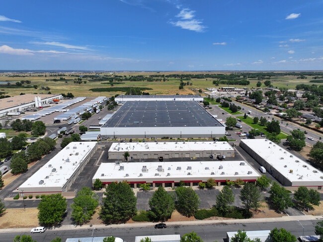
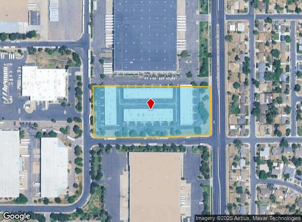

This Property Is For Sale
Current Lease Availabilities
NEARBY LISTINGS FOR SALE OR LEASE
Property Detail
5475 Peoria St
1141-04-022
Plaza Industrial Condo
Commercialcondominium
PEORIA PLAZA INDUSTRIAL CONDOS BLDG 1 UNIT-108
X
Denver
08005C0050K
Colorado
2024
0.13 AC
2024
Cent E I-70/Montbello
980100
Denver
1,680 SF
Denver-Aurora-Lakewood, CO
DEMOGRAPHICS near 5475 Peoria St
1 Mile
3 Mile
5 Mile
2024 Total Population
8,403
69,404
228,097
2029 Population
8,367
70,564
232,799
Pop Growth 2024-2029
(0.43%)
+ 1.67%
+ 2.06%
Average Age
34
34
35
2024 Total Households
2,163
21,080
75,525
HH Growth 2024-2029
(0.60%)
+ 1.76%
+ 2.11%
Median Household Inc
$59,550
$96,400
$71,680
Avg Household Size
3.40
3.10
2.90
2024 Avg HH Vehicles
2.00
2.00
2.00
Median Home Value
$326,186
$426,102
$397,326
Median Year Built
1969
2001
1983
Nearby Places
- Restaurants
- Banks
- Shops
- Fitness
- Groceries
PUBLIC TRANSPORTATION
COMMUTER RAIL
DRIVE
WALK
Distance
5 min
2.1 mi
DRIVE
WALK
Distance
5 min
2.2 mi
AIRPORT
Denver International
DRIVE
WALK
Distance
Denver International
20 min
13.2 mi
Nearby Properties
Address
Land Use
TOTAL SIZE
Lot Size
Zoning
Address
Land Use
TOTAL SIZE
Lot Size
Zoning
880,442 SF
67.95 AC
I-B
Address
Land Use
TOTAL SIZE
Lot Size
Zoning
269,025 SF
18.86 AC
M-RX-5
Address
Land Use
TOTAL SIZE
Lot Size
Zoning
335,757 SF
36.88 AC
CMP-EI2
Address
Land Use
TOTAL SIZE
Lot Size
Zoning
3,573.99 AC
A3
Address
Land Use
TOTAL SIZE
Lot Size
Zoning
390,822 SF
13.47 AC
O-1
Address
Land Use
TOTAL SIZE
Lot Size
Zoning
651,423 SF
82.50 AC
I-2
Address
Land Use
TOTAL SIZE
Lot Size
Zoning
646,975 SF
32.60 AC
M-IMX-8
Address
Land Use
TOTAL SIZE
Lot Size
Zoning
37,246 SF
87.83 AC
OS-A
Address
Land Use
TOTAL SIZE
Lot Size
Zoning
33.01 AC
M-IMX-12
Address
Land Use
TOTAL SIZE
Lot Size
Zoning
269,622 SF
12.90 AC
Address
Land Use
TOTAL SIZE
Lot Size
Zoning
723,053 SF
32.44 AC
M-IMX-12
Address
Land Use
TOTAL SIZE
Lot Size
Zoning
268,268 SF
29.99 AC
I-B
Address
Land Use
TOTAL SIZE
Lot Size
Zoning
124,526 SF
10 AC
M-RH-3
Address
Land Use
TOTAL SIZE
Lot Size
Zoning
640 AC
A3
Address
Land Use
TOTAL SIZE
Lot Size
Zoning
640 AC
A3
Address
Land Use
TOTAL SIZE
Lot Size
Zoning
400,000 SF
22.91 AC
I-0
Address
Land Use
TOTAL SIZE
Lot Size
Zoning
492,387 SF
50.21 AC
C-MU-30
Address
Land Use
TOTAL SIZE
Lot Size
Zoning
466,055 SF
24.82 AC
M-IMX-5
Address
Land Use
TOTAL SIZE
Lot Size
Zoning
277,005 SF
16.37 AC
Address
Land Use
TOTAL SIZE
Lot Size
Zoning
455,850 SF
18.65 AC
I-B
Address
Land Use
TOTAL SIZE
Lot Size
Zoning
142,708 SF
14.61 AC
Address
Land Use
TOTAL SIZE
Lot Size
Zoning
424,700 SF
31.64 AC
PUD
Address
Land Use
TOTAL SIZE
Lot Size
Zoning
426,510 SF
32.17 AC
GTWY
Address
Land Use
TOTAL SIZE
Lot Size
Zoning
354,425 SF
18.44 AC
I-1
Address
Land Use
TOTAL SIZE
Lot Size
Zoning
142,849 SF
15 AC
PUD
Address
Land Use
TOTAL SIZE
Lot Size
Zoning
391,974 SF
19.31 AC
C-MU-30
Address
Land Use
TOTAL SIZE
Lot Size
Zoning
399,704 SF
20.60 AC
C-MU-30
Address
Land Use
TOTAL SIZE
Lot Size
Zoning
347,475 SF
19.72 AC
C-MU-30
Address
Land Use
TOTAL SIZE
Lot Size
Zoning
97,626 SF
14.18 AC
Address
Land Use
TOTAL SIZE
Lot Size
Zoning
213,044 SF
17.95 AC
I-B
The World's #1 Commercial Real Estate Marketplace
Connect with us
© 2025 CoStar Group
The information above has been obtained from sources believed reliable. While we do not doubt its accuracy we have not verified it and make no guarantee, warranty or representation about it. It is your responsibility to independently confirm its accuracy and completeness. Any projections, opinions, assumptions, or estimates used are for example only and do not represent the current or future performance of the property. The value of this transaction to you depends on tax and other factors which should be evaluated by your tax, financial, and legal advisors. You and your advisors should conduct a careful, independent investigation of the property to determine to your satisfaction the suitability of the property for your needs.