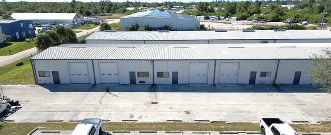
Property Record
5475 Williamsburg Dr, Punta Gorda, FL 33982


Property Detail
5475 Williamsburg Dr
402334403003
1775 INDUSTRIAL PK LTS 33 & 36 710/1388 762/402 984/387 984/388 984/389 984/390MERGER 1100/1750 1655/877 1865/2092 3355/1645
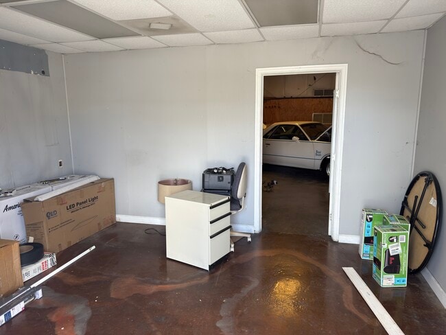
Warehouse
Charlotte
IG
Florida
AE The base floodplain where base flood elevations are provided. AE Zones are now used on new format FIRMs instead of A1-A30 Zones.
33,36
2024
0.90 AC
2025
Charlotte County
010200
Southwest Florida
11,776 SF
Punta Gorda, FL
NEARBY LISTINGS FOR SALE OR LEASE
DEMOGRAPHICS near 5475 Williamsburg Dr
1 mile
3 mile
5 mile
2025 Total Population
2,528
12,547
51,065
2030 Population
2,766
13,810
56,320
Pop Growth 2025-2030
+ 9.41%
+ 10.07%
+ 10.29%
Average Age
52
49
54
2025 Total Households
1,180
5,692
23,918
HH Growth 2025-2030
+ 9.24%
+ 9.98%
+ 10.23%
Median Household Inc
$53,737
$56,164
$68,250
Avg Household Size
2.10
2.10
2.00
2025 Avg HH Vehicles
2.00
2.00
2.00
Median Home Value
$239,285
$316,115
$343,836
Median Year Built
1991
1994
1995
Nearby Places
Map Layers
Map Styles
 Street
 Aerial
Transit
 Traffic
 Biking
Places
Listings with unknown addresses are not visible on the map
- Restaurants
- Banks
- Shops
- Fitness
- Groceries
PUBLIC TRANSPORTATION
AIRPORT
Punta Gorda
Drive
Walk
Distance
Punta Gorda
8 min
3.9 mi
Freight Ports
Port Manatee
Drive
Walk
Distance
Port Manatee
85 min
72.1 mi
Nearby Properties
Address
Land Use
TOTAL SIZE
Lot Size
Zoning
Address
Land Use
TOTAL SIZE
Lot Size
Zoning
349,844 SF
78.47 AC
P
Address
Land Use
TOTAL SIZE
Lot Size
Zoning
164,121 SF
44.20 AC
ECAP
Address
Land Use
TOTAL SIZE
Lot Size
Zoning
161,439 SF
171 AC
RE1
Address
Land Use
TOTAL SIZE
Lot Size
Zoning
121,585 SF
696.03 AC
RE1
Address
Land Use
TOTAL SIZE
Lot Size
Zoning
345,043 SF
33.12 AC
ECAP
Address
Land Use
TOTAL SIZE
Lot Size
Zoning
249,777 SF
48 AC
RMF10
Address
Land Use
TOTAL SIZE
Lot Size
Zoning
254.31 AC
PD
Address
Land Use
TOTAL SIZE
Lot Size
Zoning
62,415 SF
281.65 AC
ECAP
Address
Land Use
TOTAL SIZE
Lot Size
Zoning
385,350 SF
374.81 AC
ECAP
Address
Land Use
TOTAL SIZE
Lot Size
Zoning
134,308 SF
16 AC
RSF3.5
Address
Land Use
TOTAL SIZE
Lot Size
Zoning
125.54 AC
PD
Address
Land Use
TOTAL SIZE
Lot Size
Zoning
24,880 SF
84.50 AC
PKR
Address
Land Use
TOTAL SIZE
Lot Size
Zoning
30,940 SF
0.42 AC
NC
Address
Land Use
TOTAL SIZE
Lot Size
Zoning
116,186 SF
20.02 AC
RMF10
Address
Land Use
TOTAL SIZE
Lot Size
Zoning
136.11 AC
ECAP
Address
Land Use
TOTAL SIZE
Lot Size
Zoning
60,000 SF
9.87 AC
ECAP
Address
Land Use
TOTAL SIZE
Lot Size
Zoning
66,461 SF
10.86 AC
CG
Address
Land Use
TOTAL SIZE
Lot Size
Zoning
54.25 AC
RMF10
Address
Land Use
TOTAL SIZE
Lot Size
Zoning
103,870 SF
17.06 AC
CG
Address
Land Use
TOTAL SIZE
Lot Size
Zoning
1,556 SF
23.08 AC
CG
Address
Land Use
TOTAL SIZE
Lot Size
Zoning
7,964 SF
7.86 AC
ECAP
Address
Land Use
TOTAL SIZE
Lot Size
Zoning
14,980 SF
2.57 AC
OMI
Address
Land Use
TOTAL SIZE
Lot Size
Zoning
60,000 SF
1.44 AC
ECAP
Address
Land Use
TOTAL SIZE
Lot Size
Zoning
60.56 AC
PD
Address
Land Use
TOTAL SIZE
Lot Size
Zoning
46,912 SF
3.41 AC
CG
Address
Land Use
TOTAL SIZE
Lot Size
Zoning
22,058 SF
19.32 AC
RMF5
Address
Land Use
TOTAL SIZE
Lot Size
Zoning
30,719 SF
107.17 AC
PKR
Address
Land Use
TOTAL SIZE
Lot Size
Zoning
31,194 SF
7.93 AC
CG
Address
Land Use
TOTAL SIZE
Lot Size
Zoning
12,780 SF
86.57 AC
ECAP
Address
Land Use
TOTAL SIZE
Lot Size
Zoning
34,854 SF
655 AC
ES
The World's #1 Commercial Real Estate Marketplace
Connect with us
© 2026 CoStar Group
The information above has been obtained from sources believed reliable. While we do not doubt its accuracy we have not verified it and make no guarantee, warranty or representation about it. It is your responsibility to independently confirm its accuracy and completeness. Any projections, opinions, assumptions, or estimates used are for example only and do not represent the current or future performance of the property. The value of this transaction to you depends on tax and other factors which should be evaluated by your tax, financial, and legal advisors. You and your advisors should conduct a careful, independent investigation of the property to determine to your satisfaction the suitability of the property for your needs.