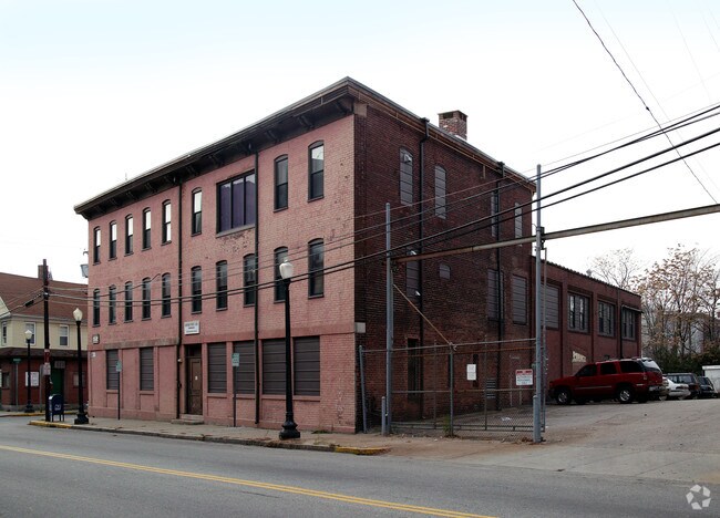
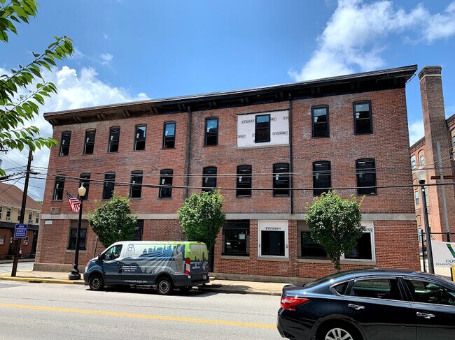
Property Record
548 Roosevelt Ave, Central Falls, RI 02863

Property Detail
548 Roosevelt Ave
Apartment
Providence
M-2
Rhode Island
B and X Area of moderate flood hazard, usually the area between the limits of the 100-year and 500-year floods.
0.38 AC
2025
Central Falls
2025
Providence
010800
Providence-Warwick, RI-MA
20,468 SF
CENT-000001-000000-000331
NEARBY LISTINGS FOR SALE OR LEASE
DEMOGRAPHICS near 548 Roosevelt Ave
1 mile
3 mile
5 mile
2025 Total Population
38,180
148,496
293,971
2030 Population
38,767
152,158
302,506
Pop Growth 2025-2030
+ 1.54%
+ 2.47%
+ 2.90%
Average Age
37
40
40
2025 Total Households
15,196
59,620
119,090
HH Growth 2025-2030
+ 1.71%
+ 2.50%
+ 3.06%
Median Household Inc
$53,438
$71,838
$76,924
Avg Household Size
2.40
2.40
2.30
2025 Avg HH Vehicles
1.00
2.00
2.00
Median Home Value
$322,276
$355,138
$387,383
Median Year Built
1948
1952
1954
Nearby Places
Map Layers
Map Styles
 Street
 Aerial
Layers
 Traffic
 Biking
Places
Listings with unknown addresses are not visible on the map
- Restaurants
- Banks
- Shops
- Fitness
- Groceries
PUBLIC TRANSPORTATION
COMMUTER RAIL
South Attleboro (Providence/Stoughton Line - Massachusetts Bay Transportation Authority Commuter Rail (Purple Line))
Drive
Walk
Distance
South Attleboro (Providence/Stoughton Line - Massachusetts Bay Transportation Authority Commuter Rail (Purple Line))
4 min
2.2 mi
Providence (Providence/Stoughton Line - Massachusetts Bay Transportation Authority Commuter Rail (Purple Line))
Drive
Walk
Distance
Providence (Providence/Stoughton Line - Massachusetts Bay Transportation Authority Commuter Rail (Purple Line))
10 min
5.8 mi
AIRPORT
Rhode Island Tf Green International
Drive
Walk
Distance
Rhode Island Tf Green International
26 min
14.0 mi
Worcester Regional
Drive
Walk
Distance
Worcester Regional
61 min
43.6 mi
General Edward Lawrence Logan International
Drive
Walk
Distance
General Edward Lawrence Logan International
62 min
46.5 mi
Freight Ports
Port of Davisville, RI
Drive
Walk
Distance
Port of Davisville, RI
42 min
26.3 mi
The World's #1 Commercial Real Estate Marketplace
Connect with us
© 2026 CoStar Group
The information above has been obtained from sources believed reliable. While we do not doubt its accuracy we have not verified it and make no guarantee, warranty or representation about it. It is your responsibility to independently confirm its accuracy and completeness. Any projections, opinions, assumptions, or estimates used are for example only and do not represent the current or future performance of the property. The value of this transaction to you depends on tax and other factors which should be evaluated by your tax, financial, and legal advisors. You and your advisors should conduct a careful, independent investigation of the property to determine to your satisfaction the suitability of the property for your needs.