Property Record
548 W Twincourt Trl, Saint Augustine, FL 32095


Property Detail
548 W Twincourt Trl
027090-0070
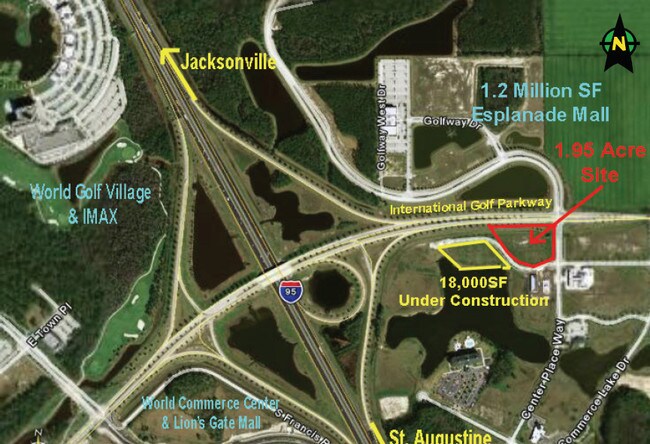
2-7 PT OF GL 1 LYING S OF INTERNATIONAL GOLF PARKWAY - SOUTHEAST QUADRANT PARCEL 7 OR4770/380
Commercialnec
ST. JOHNS
PUD
Florida
B and X Area of moderate flood hazard, usually the area between the limits of the 100-year and 500-year floods.
2-7
2025
0.96 AC
2026
St Johns County
020904
Jacksonville (Florida)
5,589 SF
Jacksonville, FL
NEARBY LISTINGS FOR SALE OR LEASE
DEMOGRAPHICS near 548 W Twincourt Trl
1 mile
3 mile
5 mile
2025 Total Population
2,763
10,942
41,037
2030 Population
3,374
13,039
48,136
Pop Growth 2025-2030
+ 22.11%
+ 19.16%
+ 17.30%
Average Age
39
46
42
2025 Total Households
1,031
4,463
14,690
HH Growth 2025-2030
+ 22.11%
+ 19.74%
+ 18.06%
Median Household Inc
$109,730
$107,491
$118,510
Avg Household Size
2.70
2.40
2.70
2025 Avg HH Vehicles
2.00
2.00
2.00
Median Home Value
$493,611
$463,515
$509,590
Median Year Built
2011
2010
2010
Nearby Places
Map Layers
Map Styles
 Street
 Aerial
Layers
 Traffic
 Biking
Places
Listings with unknown addresses are not visible on the map
- Restaurants
- Banks
- Shops
- Fitness
- Groceries
PUBLIC TRANSPORTATION
AIRPORT
Jacksonville International
Drive
Walk
Distance
Jacksonville International
55 min
42.5 mi
Freight Ports
Jacksonville Port
Drive
Walk
Distance
Jacksonville Port
42 min
31.4 mi
SALE & LEASE HISTORY
LISTING DATE
SALE/LEASE

Sep 24, 2016
For Sale
Mar 30, 2017
For Sale
Nearby Properties
Address
Land Use
TOTAL SIZE
Lot Size
Zoning
Address
Land Use
TOTAL SIZE
Lot Size
Zoning
38.75 AC
Address
Land Use
TOTAL SIZE
Lot Size
Zoning
312,893 SF
12.30 AC
Address
Land Use
TOTAL SIZE
Lot Size
Zoning
223,545 SF
68.79 AC
OR
Address
Land Use
TOTAL SIZE
Lot Size
Zoning
252,962 SF
6.86 AC
Address
Land Use
TOTAL SIZE
Lot Size
Zoning
228,680 SF
11.13 AC
Address
Land Use
TOTAL SIZE
Lot Size
Zoning
157,964 SF
66.39 AC
PUD
Address
Land Use
TOTAL SIZE
Lot Size
Zoning
90,363 SF
15.69 AC
PUD
Address
Land Use
TOTAL SIZE
Lot Size
Zoning
99,542 SF
18.10 AC
Address
Land Use
TOTAL SIZE
Lot Size
Zoning
346,647 SF
40.12 AC
PUD
Address
Land Use
TOTAL SIZE
Lot Size
Zoning
50,439 SF
15.50 AC
PUD
Address
Land Use
TOTAL SIZE
Lot Size
Zoning
91,029 SF
15.68 AC
DRI
Address
Land Use
TOTAL SIZE
Lot Size
Zoning
151,858 SF
17.24 AC
Address
Land Use
TOTAL SIZE
Lot Size
Zoning
52,896 SF
13.70 AC
Address
Land Use
TOTAL SIZE
Lot Size
Zoning
109,852 SF
12.62 AC
Address
Land Use
TOTAL SIZE
Lot Size
Zoning
81,978 SF
2.48 AC
PUD
Address
Land Use
TOTAL SIZE
Lot Size
Zoning
150,535 SF
31.11 AC
OR
Address
Land Use
TOTAL SIZE
Lot Size
Zoning
78,878 SF
12.18 AC
PUD
Address
Land Use
TOTAL SIZE
Lot Size
Zoning
27.10 AC
Address
Land Use
TOTAL SIZE
Lot Size
Zoning
267,806 SF
2.19 AC
Address
Land Use
TOTAL SIZE
Lot Size
Zoning
107,352 SF
15.88 AC
Address
Land Use
TOTAL SIZE
Lot Size
Zoning
42,168 SF
11.07 AC
PUD
Address
Land Use
TOTAL SIZE
Lot Size
Zoning
47,784 SF
9.61 AC
Address
Land Use
TOTAL SIZE
Lot Size
Zoning
84,211 SF
10.39 AC
DRI
Address
Land Use
TOTAL SIZE
Lot Size
Zoning
67.16 AC
PUD
Address
Land Use
TOTAL SIZE
Lot Size
Zoning
27,037 SF
9 AC
OR
Address
Land Use
TOTAL SIZE
Lot Size
Zoning
71,968 SF
4.28 AC
PUD
Address
Land Use
TOTAL SIZE
Lot Size
Zoning
91.92 AC
PUD
Address
Land Use
TOTAL SIZE
Lot Size
Zoning
74,832 SF
6 AC
DRI
Address
Land Use
TOTAL SIZE
Lot Size
Zoning
96,926 SF
5.42 AC
DRI
Address
Land Use
TOTAL SIZE
Lot Size
Zoning
20,362 SF
4.75 AC
The World's #1 Commercial Real Estate Marketplace
Connect with us
© 2026 CoStar Group
The information above has been obtained from sources believed reliable. While we do not doubt its accuracy we have not verified it and make no guarantee, warranty or representation about it. It is your responsibility to independently confirm its accuracy and completeness. Any projections, opinions, assumptions, or estimates used are for example only and do not represent the current or future performance of the property. The value of this transaction to you depends on tax and other factors which should be evaluated by your tax, financial, and legal advisors. You and your advisors should conduct a careful, independent investigation of the property to determine to your satisfaction the suitability of the property for your needs.