Property Record
5480 142Nd St E, Rosemount, MN 55068
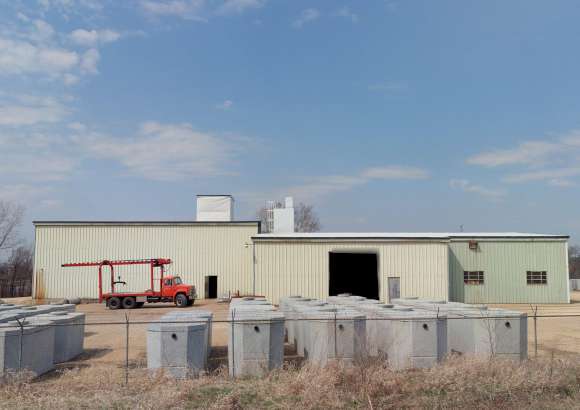

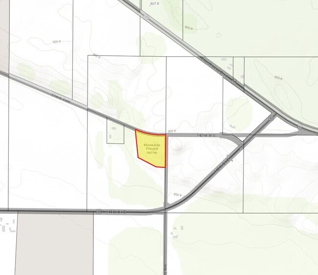
Property Detail
5480 142Nd St E
Minneapolis-St. Paul-Bloomington, MN-WI
29 115 18 PT OF E 1/2 OF NE 1/4 COM SE COR N 765.59 FT TO BEG N 551.07 FT TO C/L RD NW ON C/L 518.18 FT S 455.39 FT S 62D 47M 28S E 337.14 FT S 86D 21M 50 S E165 FT TO BEG SECTION 29 TWN 115 RANGE 18
34-02900-11-010
Dakota
Industrialgeneral
Minnesota
B and X Area of moderate flood hazard, usually the area between the limits of the 100-year and 500-year floods.
10
2024
5.71 AC
2024
South Central
061003
Minneapolis/St Paul
15,942 SF
NEARBY LISTINGS FOR SALE OR LEASE
-
-
View all Rosemount listings for sale on LoopNet.com
DEMOGRAPHICS near 5480 142Nd St E
1 mile
3 mile
5 mile
2025 Total Population
35
837
11,448
2030 Population
39
868
12,208
Pop Growth 2025-2030
+ 11.43%
+ 3.70%
+ 6.64%
Average Age
38
41
38
2025 Total Households
11
301
3,848
HH Growth 2025-2030
+ 18.18%
+ 3.65%
+ 6.63%
Median Household Inc
$166,666
$116,227
$146,356
Avg Household Size
3.10
2.80
2.90
2025 Avg HH Vehicles
2.00
3.00
2.00
Median Home Value
$600,000
$456,249
$472,041
Median Year Built
2011
1978
1999
Nearby Places
Map Layers
Map Styles
 Street
 Aerial
Transit
 Traffic
 Biking
Places
Listings with unknown addresses are not visible on the map
- Restaurants
- Banks
- Shops
- Fitness
- Groceries
PUBLIC TRANSPORTATION
AIRPORT
Minneapolis-St Paul International/Wold-Chamberlain
Drive
Walk
Distance
Minneapolis-St Paul International/Wold-Chamberlain
27 min
18.7 mi
Nearby Properties
Address
Land Use
TOTAL SIZE
Lot Size
Zoning
Address
Land Use
TOTAL SIZE
Lot Size
Zoning
595.66 AC
Address
Land Use
TOTAL SIZE
Lot Size
Zoning
569,250 SF
97.05 AC
Address
Land Use
TOTAL SIZE
Lot Size
Zoning
600 SF
348.83 AC
Address
Land Use
TOTAL SIZE
Lot Size
Zoning
114,778 SF
27.86 AC
Address
Land Use
TOTAL SIZE
Lot Size
Zoning
178,943 SF
15.45 AC
Address
Land Use
TOTAL SIZE
Lot Size
Zoning
470.06 AC
Address
Land Use
TOTAL SIZE
Lot Size
Zoning
253,896 SF
121.68 AC
Address
Land Use
TOTAL SIZE
Lot Size
Zoning
159,414 SF
25.25 AC
Address
Land Use
TOTAL SIZE
Lot Size
Zoning
41,928 SF
19.44 AC
Address
Land Use
TOTAL SIZE
Lot Size
Zoning
57,238 SF
51.12 AC
Address
Land Use
TOTAL SIZE
Lot Size
Zoning
238.57 AC
Address
Land Use
TOTAL SIZE
Lot Size
Zoning
35.79 AC
Address
Land Use
TOTAL SIZE
Lot Size
Zoning
56,594 SF
34.09 AC
Address
Land Use
TOTAL SIZE
Lot Size
Zoning
94,782 SF
32.84 AC
Address
Land Use
TOTAL SIZE
Lot Size
Zoning
4,320 SF
39.92 AC
Address
Land Use
TOTAL SIZE
Lot Size
Zoning
3,660 SF
87.34 AC
Address
Land Use
TOTAL SIZE
Lot Size
Zoning
35,504 SF
28.35 AC
Address
Land Use
TOTAL SIZE
Lot Size
Zoning
20,208 SF
12.63 AC
Address
Land Use
TOTAL SIZE
Lot Size
Zoning
23,249 SF
10.65 AC
Address
Land Use
TOTAL SIZE
Lot Size
Zoning
7,924 SF
131.85 AC
Address
Land Use
TOTAL SIZE
Lot Size
Zoning
33,624 SF
5.46 AC
Address
Land Use
TOTAL SIZE
Lot Size
Zoning
1,148 SF
160.23 AC
Address
Land Use
TOTAL SIZE
Lot Size
Zoning
16.68 AC
Address
Land Use
TOTAL SIZE
Lot Size
Zoning
158.92 AC
Address
Land Use
TOTAL SIZE
Lot Size
Zoning
19,648 SF
5.84 AC
Address
Land Use
TOTAL SIZE
Lot Size
Zoning
Address
Land Use
TOTAL SIZE
Lot Size
Zoning
864 SF
159.53 AC
Address
Land Use
TOTAL SIZE
Lot Size
Zoning
2,170 SF
40.03 AC
Address
Land Use
TOTAL SIZE
Lot Size
Zoning
133.52 AC
The World's #1 Commercial Real Estate Marketplace
Connect with us
© 2026 CoStar Group
The information above has been obtained from sources believed reliable. While we do not doubt its accuracy we have not verified it and make no guarantee, warranty or representation about it. It is your responsibility to independently confirm its accuracy and completeness. Any projections, opinions, assumptions, or estimates used are for example only and do not represent the current or future performance of the property. The value of this transaction to you depends on tax and other factors which should be evaluated by your tax, financial, and legal advisors. You and your advisors should conduct a careful, independent investigation of the property to determine to your satisfaction the suitability of the property for your needs.