Property Record
5480 Monterey Rd, Gilroy, CA 95020


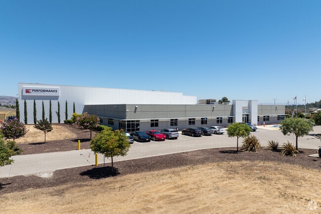
Property Detail
5480 Monterey Rd
Foodprocessing
Santa Clara
CM
California
A Areas with a 1% annual chance of flooding and a 26% chance of flooding over the life of a 30-year mortgage.
28.73 AC
2024
Outlying Santa Clara Cnty
2025
South Bay/San Jose
512602
San Jose-Sunnyvale-Santa Clara, CA
189,303 SF
841-14-084
NEARBY LISTINGS FOR SALE OR LEASE
DEMOGRAPHICS near 5480 Monterey Rd
1 mile
3 mile
5 mile
2025 Total Population
2,105
32,542
63,101
2030 Population
2,139
33,351
64,342
Pop Growth 2025-2030
+ 1.62%
+ 2.49%
+ 1.97%
Average Age
38
38
39
2025 Total Households
608
9,332
18,495
HH Growth 2025-2030
+ 1.48%
+ 2.46%
+ 1.97%
Median Household Inc
$152,823
$114,396
$127,653
Avg Household Size
3.40
3.30
3.30
2025 Avg HH Vehicles
3.00
2.00
2.00
Median Home Value
$906,441
$863,220
$976,523
Median Year Built
1994
1982
1988
Nearby Places
Map Layers
Map Styles
 Street
 Aerial
Layers
 Traffic
 Biking
Places
Listings with unknown addresses are not visible on the map
- Restaurants
- Banks
- Shops
- Fitness
- Groceries
PUBLIC TRANSPORTATION
COMMUTER RAIL
Gilroy Caltrain Station Southbound (South Santa Clara County Connector - Caltrain (Caltrain))
Drive
Walk
Distance
Gilroy Caltrain Station Southbound (South Santa Clara County Connector - Caltrain (Caltrain))
3 min
1.8 mi
San Martin Caltrain Station Northbound (South Santa Clara County Connector - Caltrain (Caltrain))
Drive
Walk
Distance
San Martin Caltrain Station Northbound (South Santa Clara County Connector - Caltrain (Caltrain))
12 min
8.9 mi
Freight Ports
Port of Redwood City
Drive
Walk
Distance
Port of Redwood City
67 min
55.2 mi
Nearby Properties
Address
Land Use
TOTAL SIZE
Lot Size
Zoning
Address
Land Use
TOTAL SIZE
Lot Size
Zoning
270,205 SF
6.65 AC
M2
Address
Land Use
TOTAL SIZE
Lot Size
Zoning
921,750 SF
40.33 AC
M2
Address
Land Use
TOTAL SIZE
Lot Size
Zoning
133,498 SF
12.16 AC
C3
Address
Land Use
TOTAL SIZE
Lot Size
Zoning
156,290 SF
5.87 AC
APD
Address
Land Use
TOTAL SIZE
Lot Size
Zoning
55.03 AC
AW
Address
Land Use
TOTAL SIZE
Lot Size
Zoning
113,883 SF
9.63 AC
C1
Address
Land Use
TOTAL SIZE
Lot Size
Zoning
172,348 SF
9.58 AC
A140
Address
Land Use
TOTAL SIZE
Lot Size
Zoning
11.04 AC
M2
Address
Land Use
TOTAL SIZE
Lot Size
Zoning
9.90 AC
M2
Address
Land Use
TOTAL SIZE
Lot Size
Zoning
94,345 SF
10.68 AC
C1
Address
Land Use
TOTAL SIZE
Lot Size
Zoning
219,622 SF
19.80 AC
A1-25
Address
Land Use
TOTAL SIZE
Lot Size
Zoning
56.33 AC
M2
Address
Land Use
TOTAL SIZE
Lot Size
Zoning
59.87 AC
M2
Address
Land Use
TOTAL SIZE
Lot Size
Zoning
142,684 SF
4.94 AC
CD
Address
Land Use
TOTAL SIZE
Lot Size
Zoning
123,268 SF
7.62 AC
R3
Address
Land Use
TOTAL SIZE
Lot Size
Zoning
64,893 SF
4.32 AC
R3
Address
Land Use
TOTAL SIZE
Lot Size
Zoning
148,663 SF
14.79 AC
PUD
Address
Land Use
TOTAL SIZE
Lot Size
Zoning
4,853 SF
11.59 AC
HC
Address
Land Use
TOTAL SIZE
Lot Size
Zoning
32,727 SF
1.82 AC
M2
Address
Land Use
TOTAL SIZE
Lot Size
Zoning
63,560 SF
7.63 AC
A1-25
Address
Land Use
TOTAL SIZE
Lot Size
Zoning
123,709 SF
9.26 AC
M2
Address
Land Use
TOTAL SIZE
Lot Size
Zoning
56,020 SF
2.61 AC
M2
Address
Land Use
TOTAL SIZE
Lot Size
Zoning
126,503 SF
4.61 AC
MI
Address
Land Use
TOTAL SIZE
Lot Size
Zoning
20,140.41 AC
SJ
Address
Land Use
TOTAL SIZE
Lot Size
Zoning
163,200 SF
8.62 AC
M-2
Address
Land Use
TOTAL SIZE
Lot Size
Zoning
1.51 AC
CM
Address
Land Use
TOTAL SIZE
Lot Size
Zoning
96,524 SF
5 AC
R3
Address
Land Use
TOTAL SIZE
Lot Size
Zoning
77,519 SF
3.05 AC
HC
The World's #1 Commercial Real Estate Marketplace
Connect with us
© 2026 CoStar Group
The information above has been obtained from sources believed reliable. While we do not doubt its accuracy we have not verified it and make no guarantee, warranty or representation about it. It is your responsibility to independently confirm its accuracy and completeness. Any projections, opinions, assumptions, or estimates used are for example only and do not represent the current or future performance of the property. The value of this transaction to you depends on tax and other factors which should be evaluated by your tax, financial, and legal advisors. You and your advisors should conduct a careful, independent investigation of the property to determine to your satisfaction the suitability of the property for your needs.