Property Record
5480 Us Highway 17 N, Kingsland, GA 31548
NEARBY LISTINGS FOR SALE OR LEASE
-
-
View all Kingsland listings for sale on LoopNet.com
Property Detail
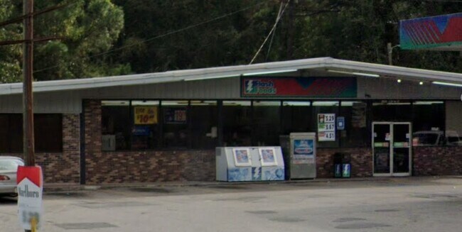
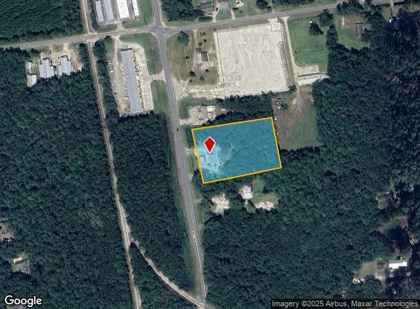
5480 Us Highway 17 N
082D-02-005
Whigam S/D
Conveniencestore
BLDG/L 1 WHIGAM S/D
X
Camden
13039C0379G
Georgia
2025
2.33 AC
2025
Brunswick/Kingsland
010302
Other Market Areas
3,600 SF
St. Marys, GA
DEMOGRAPHICS near 5480 Us Highway 17 N
1 Mile
3 Mile
5 Mile
2024 Total Population
826
10,872
23,279
2029 Population
918
11,885
25,571
Pop Growth 2024-2029
+ 11.14%
+ 9.32%
+ 9.85%
Average Age
37
36
37
2024 Total Households
323
4,118
8,728
HH Growth 2024-2029
+ 11.76%
+ 9.47%
+ 9.95%
Median Household Inc
$42,033
$53,716
$61,667
Avg Household Size
2.40
2.60
2.60
2024 Avg HH Vehicles
2.00
2.00
2.00
Median Home Value
$194,642
$167,058
$196,795
Median Year Built
1996
1994
1997
Nearby Places
Map Layers
Map Styles
 Street
 Aerial
- Restaurants
- Banks
- Shops
- Fitness
- Groceries
PUBLIC TRANSPORTATION
AIRPORT
Jacksonville International
DRIVE
WALK
Distance
Jacksonville International
37 min
28.7 mi
Freight Ports
Georgia Ports - Brunswick
DRIVE
WALK
Distance
Georgia Ports - Brunswick
38 min
29.4 mi
Nearby Properties
Address
Land Use
TOTAL SIZE
Lot Size
Zoning
Address
Land Use
TOTAL SIZE
Lot Size
Zoning
256,459 SF
38.54 AC
R-1
Address
Land Use
TOTAL SIZE
Lot Size
Zoning
184,547 SF
34.90 AC
R-1
Address
Land Use
TOTAL SIZE
Lot Size
Zoning
94,156 SF
74.30 AC
PD/R-1
Address
Land Use
TOTAL SIZE
Lot Size
Zoning
79,447 SF
25 AC
PD/R-1
Address
Land Use
TOTAL SIZE
Lot Size
Zoning
74,567 SF
49 AC
R-1
Address
Land Use
TOTAL SIZE
Lot Size
Zoning
76,769 SF
26 AC
R-1
Address
Land Use
TOTAL SIZE
Lot Size
Zoning
3,879 SF
10.72 AC
PD/R-3
Address
Land Use
TOTAL SIZE
Lot Size
Zoning
15,590 SF
0.71 AC
C-4
Address
Land Use
TOTAL SIZE
Lot Size
Zoning
9,530 SF
10.71 AC
PD/R-3
Address
Land Use
TOTAL SIZE
Lot Size
Zoning
66,000 SF
3.72 AC
R-3
Address
Land Use
TOTAL SIZE
Lot Size
Zoning
22,046 SF
4.50 AC
R-1
Address
Land Use
TOTAL SIZE
Lot Size
Zoning
19,600 SF
1.51 AC
C-4
Address
Land Use
TOTAL SIZE
Lot Size
Zoning
10,496 SF
20 AC
C-4
Address
Land Use
TOTAL SIZE
Lot Size
Zoning
87,500 SF
8.35 AC
I-L
Address
Land Use
TOTAL SIZE
Lot Size
Zoning
25 AC
R-1
Address
Land Use
TOTAL SIZE
Lot Size
Zoning
7,620 SF
5 AC
C-4
Address
Land Use
TOTAL SIZE
Lot Size
Zoning
11,408 SF
6.37 AC
I-G
Address
Land Use
TOTAL SIZE
Lot Size
Zoning
2,224 SF
16.43 AC
PD/R-3
Address
Land Use
TOTAL SIZE
Lot Size
Zoning
31,491 SF
3.42 AC
R-1
Address
Land Use
TOTAL SIZE
Lot Size
Zoning
32,115 SF
1.12 AC
C-4
Address
Land Use
TOTAL SIZE
Lot Size
Zoning
18,000 SF
3.51 AC
R-1
Address
Land Use
TOTAL SIZE
Lot Size
Zoning
18,000 SF
23.91 AC
R-1
Address
Land Use
TOTAL SIZE
Lot Size
Zoning
18,352 SF
5 AC
C-2
Address
Land Use
TOTAL SIZE
Lot Size
Zoning
23,687 SF
1.77 AC
C-2
Address
Land Use
TOTAL SIZE
Lot Size
Zoning
33,537 SF
2.25 AC
R-1
Address
Land Use
TOTAL SIZE
Lot Size
Zoning
9,492 SF
3.10 AC
C-4
Address
Land Use
TOTAL SIZE
Lot Size
Zoning
7,896 SF
2.31 AC
C-4
Address
Land Use
TOTAL SIZE
Lot Size
Zoning
52,775 SF
11.20 AC
I-G
Address
Land Use
TOTAL SIZE
Lot Size
Zoning
39,600 SF
1.63 AC
C-4
Address
Land Use
TOTAL SIZE
Lot Size
Zoning
15,102 SF
5 AC
R-1
The World's #1 Commercial Real Estate Marketplace
Connect with us
© 2025 CoStar Group
The information above has been obtained from sources believed reliable. While we do not doubt its accuracy we have not verified it and make no guarantee, warranty or representation about it. It is your responsibility to independently confirm its accuracy and completeness. Any projections, opinions, assumptions, or estimates used are for example only and do not represent the current or future performance of the property. The value of this transaction to you depends on tax and other factors which should be evaluated by your tax, financial, and legal advisors. You and your advisors should conduct a careful, independent investigation of the property to determine to your satisfaction the suitability of the property for your needs.