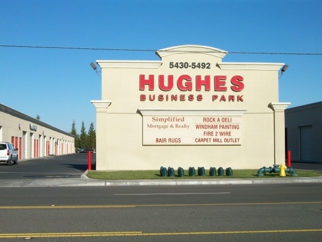
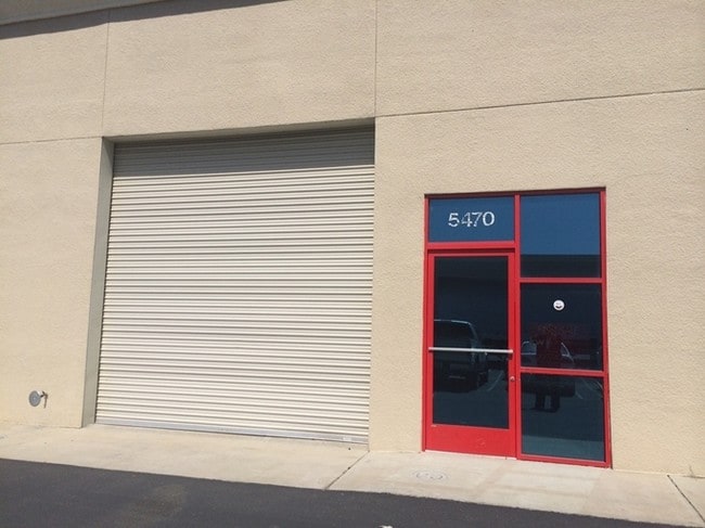
Property Record
5482 Pirrone Rd, Salida, CA 95368

NEARBY LISTINGS FOR SALE OR LEASE
Property Detail
5482 Pirrone Rd
Modesto, CA
Parcel Map
136-35-18
50 PM 96 LOT 12
Warehouse
Stanislaus
X
California
06077C0805F
12
2025
0.11 AC
2025
Outlying Stanislaus Cty
000501
Stockton/Modesto
2,080 SF
DEMOGRAPHICS near 5482 Pirrone Rd
1 Mile
3 Mile
5 Mile
2024 Total Population
7,858
33,932
77,161
2029 Population
7,807
34,595
78,262
Pop Growth 2024-2029
(0.65%)
+ 1.95%
+ 1.43%
Average Age
37
38
38
2024 Total Households
2,321
11,072
25,690
HH Growth 2024-2029
(0.69%)
+ 2.13%
+ 1.48%
Median Household Inc
$87,276
$93,727
$88,422
Avg Household Size
3.30
3.00
2.90
2024 Avg HH Vehicles
3.00
2.00
2.00
Median Home Value
$373,630
$453,858
$452,336
Median Year Built
1992
1989
1986
Nearby Places
Map Layers
Map Styles
 Street
 Aerial
- Restaurants
- Banks
- Shops
- Fitness
- Groceries
PUBLIC TRANSPORTATION
AIRPORT
Stockton Metro
DRIVE
WALK
Distance
Stockton Metro
28 min
17.8 mi
Freight Ports
Port of Stockton
DRIVE
WALK
Distance
Port of Stockton
36 min
26.3 mi
Nearby Properties
Address
Land Use
TOTAL SIZE
Lot Size
Zoning
Address
Land Use
TOTAL SIZE
Lot Size
Zoning
640,835 SF
47.18 AC
PC
Address
Land Use
TOTAL SIZE
Lot Size
Zoning
541,375 SF
37.18 AC
Address
Land Use
TOTAL SIZE
Lot Size
Zoning
706,042 SF
24.81 AC
PD109
Address
Land Use
TOTAL SIZE
Lot Size
Zoning
25,000 SF
131.14 AC
Address
Land Use
TOTAL SIZE
Lot Size
Zoning
6,160 SF
46.47 AC
Address
Land Use
TOTAL SIZE
Lot Size
Zoning
9.25 AC
MODSP
Address
Land Use
TOTAL SIZE
Lot Size
Zoning
127,142 SF
3.89 AC
MODSP
Address
Land Use
TOTAL SIZE
Lot Size
Zoning
33,530 SF
3.60 AC
Address
Land Use
TOTAL SIZE
Lot Size
Zoning
164,473 SF
3.50 AC
MODSP
Address
Land Use
TOTAL SIZE
Lot Size
Zoning
155,462 SF
13.69 AC
PD
Address
Land Use
TOTAL SIZE
Lot Size
Zoning
41,260 SF
6 AC
MODSP
Address
Land Use
TOTAL SIZE
Lot Size
Zoning
45,916 SF
4.69 AC
MODPO
Address
Land Use
TOTAL SIZE
Lot Size
Zoning
139,552 SF
12.58 AC
COUPI
Address
Land Use
TOTAL SIZE
Lot Size
Zoning
85,040 SF
4.46 AC
Address
Land Use
TOTAL SIZE
Lot Size
Zoning
130,630 SF
11.13 AC
PD
Address
Land Use
TOTAL SIZE
Lot Size
Zoning
4.36 AC
Address
Land Use
TOTAL SIZE
Lot Size
Zoning
157,353 SF
9 AC
Address
Land Use
TOTAL SIZE
Lot Size
Zoning
75,922 SF
3.93 AC
Address
Land Use
TOTAL SIZE
Lot Size
Zoning
139,638 SF
39.25 AC
Address
Land Use
TOTAL SIZE
Lot Size
Zoning
71,877 SF
2 AC
MODSP
Address
Land Use
TOTAL SIZE
Lot Size
Zoning
90,250 SF
7.16 AC
Address
Land Use
TOTAL SIZE
Lot Size
Zoning
1,052 SF
360.20 AC
A240
Address
Land Use
TOTAL SIZE
Lot Size
Zoning
123,325 SF
9.62 AC
PDCOM
Address
Land Use
TOTAL SIZE
Lot Size
Zoning
6,450 SF
17.97 AC
Address
Land Use
TOTAL SIZE
Lot Size
Zoning
87,000 SF
5.08 AC
COUPD
Address
Land Use
TOTAL SIZE
Lot Size
Zoning
60,000 SF
2.88 AC
PD
Address
Land Use
TOTAL SIZE
Lot Size
Zoning
7.82 AC
Address
Land Use
TOTAL SIZE
Lot Size
Zoning
32,983 SF
3.45 AC
MODPD
Address
Land Use
TOTAL SIZE
Lot Size
Zoning
54,000 SF
1.88 AC
Address
Land Use
TOTAL SIZE
Lot Size
Zoning
96,980 SF
5.80 AC
The World's #1 Commercial Real Estate Marketplace
Connect with us
© 2026 CoStar Group
The information above has been obtained from sources believed reliable. While we do not doubt its accuracy we have not verified it and make no guarantee, warranty or representation about it. It is your responsibility to independently confirm its accuracy and completeness. Any projections, opinions, assumptions, or estimates used are for example only and do not represent the current or future performance of the property. The value of this transaction to you depends on tax and other factors which should be evaluated by your tax, financial, and legal advisors. You and your advisors should conduct a careful, independent investigation of the property to determine to your satisfaction the suitability of the property for your needs.