Property Record
5485 N 5000E Rd, Bourbonnais, IL 60914


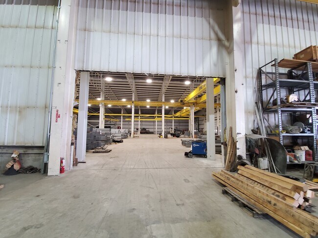
Property Detail
5485 N 5000E Rd
06-10-06-100-007
TRACT IN SH OF SH OF NWQ BAL 2.00AC 06-31-13E
Commercialnec
Kankakee
I2
Illinois
B and X Area of moderate flood hazard, usually the area between the limits of the 100-year and 500-year floods.
2 AC
2024
Illinois North Area
2025
Other Market Areas
010800
Kankakee, IL
NEARBY LISTINGS FOR SALE OR LEASE
-
-
View all Bourbonnais listings for sale on LoopNet.com
DEMOGRAPHICS near 5485 N 5000E Rd
1 mile
3 mile
5 mile
2025 Total Population
103
1,255
19,074
2030 Population
102
1,263
18,978
Pop Growth 2025-2030
(0.97%)
+ 0.64%
(0.50%)
Average Age
42
42
41
2025 Total Households
42
446
7,526
HH Growth 2025-2030
0.00%
+ 0.67%
(0.60%)
Median Household Inc
$87,500
$67,325
$81,802
Avg Household Size
2.40
2.40
2.40
2025 Avg HH Vehicles
2.00
2.00
2.00
Median Home Value
$220,833
$253,913
$217,654
Median Year Built
1974
1996
1993
Nearby Places
Map Layers
Map Styles
 Street
 Aerial
Transit
 Traffic
 Biking
Places
Listings with unknown addresses are not visible on the map
- Restaurants
- Banks
- Shops
- Fitness
- Groceries
PUBLIC TRANSPORTATION
COMMUTER RAIL
Kankakee (City of New Orleans - Amtrak, Illini - Amtrak, Saluki - Amtrak)
Drive
Walk
Distance
Kankakee (City of New Orleans - Amtrak, Illini - Amtrak, Saluki - Amtrak)
19 min
9.9 mi
Freight Ports
Port Milwaukee
Drive
Walk
Distance
Port Milwaukee
178 min
138.8 mi
SALE & LEASE HISTORY
LISTING DATE
SALE/LEASE

Jun 23, 2021
For Sale
Nearby Properties
Address
Land Use
TOTAL SIZE
Lot Size
Zoning
Address
Land Use
TOTAL SIZE
Lot Size
Zoning
Address
Land Use
TOTAL SIZE
Lot Size
Zoning
3.50 AC
I2
Address
Land Use
TOTAL SIZE
Lot Size
Zoning
10.26 AC
I2
Address
Land Use
TOTAL SIZE
Lot Size
Zoning
11.74 AC
A1
Address
Land Use
TOTAL SIZE
Lot Size
Zoning
3.33 AC
I2
Address
Land Use
TOTAL SIZE
Lot Size
Zoning
2.32 AC
I2
Address
Land Use
TOTAL SIZE
Lot Size
Zoning
10.32 AC
A1
Address
Land Use
TOTAL SIZE
Lot Size
Zoning
20 AC
I2
Address
Land Use
TOTAL SIZE
Lot Size
Zoning
2.35 AC
I2
Address
Land Use
TOTAL SIZE
Lot Size
Zoning
1 AC
A1
Address
Land Use
TOTAL SIZE
Lot Size
Zoning
0.35 AC
R1
Address
Land Use
TOTAL SIZE
Lot Size
Zoning
160 AC
A1
Address
Land Use
TOTAL SIZE
Lot Size
Zoning
1.82 AC
I2
Address
Land Use
TOTAL SIZE
Lot Size
Zoning
Address
Land Use
TOTAL SIZE
Lot Size
Zoning
1.27 AC
I2
Address
Land Use
TOTAL SIZE
Lot Size
Zoning
Address
Land Use
TOTAL SIZE
Lot Size
Zoning
0.70 AC
I2
Address
Land Use
TOTAL SIZE
Lot Size
Zoning
4.62 AC
Address
Land Use
TOTAL SIZE
Lot Size
Zoning
Address
Land Use
TOTAL SIZE
Lot Size
Zoning
1.16 AC
I2
Address
Land Use
TOTAL SIZE
Lot Size
Zoning
120 AC
A1
Address
Land Use
TOTAL SIZE
Lot Size
Zoning
1.76 AC
I2
Address
Land Use
TOTAL SIZE
Lot Size
Zoning
0.59 AC
I2
Address
Land Use
TOTAL SIZE
Lot Size
Zoning
120 AC
A1
Address
Land Use
TOTAL SIZE
Lot Size
Zoning
112.43 AC
Address
Land Use
TOTAL SIZE
Lot Size
Zoning
117.06 AC
Address
Land Use
TOTAL SIZE
Lot Size
Zoning
1.93 AC
Address
Land Use
TOTAL SIZE
Lot Size
Zoning
0.01 AC
A1
Address
Land Use
TOTAL SIZE
Lot Size
Zoning
0.73 AC
I2
The World's #1 Commercial Real Estate Marketplace
Connect with us
© 2026 CoStar Group
The information above has been obtained from sources believed reliable. While we do not doubt its accuracy we have not verified it and make no guarantee, warranty or representation about it. It is your responsibility to independently confirm its accuracy and completeness. Any projections, opinions, assumptions, or estimates used are for example only and do not represent the current or future performance of the property. The value of this transaction to you depends on tax and other factors which should be evaluated by your tax, financial, and legal advisors. You and your advisors should conduct a careful, independent investigation of the property to determine to your satisfaction the suitability of the property for your needs.