Property Record
5485 State Route 12E, Cape Vincent, NY 13618
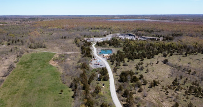
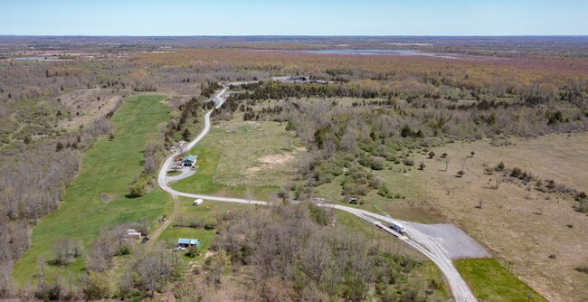
This Property Is For Sale
NEARBY LISTINGS FOR SALE OR LEASE
-
-
View all Cape Vincent listings for sale on LoopNet.com
Property Detail
5485 State Route 12E
222889-050-000-0001-056-000
Jefferson
Miscresidentialimprovement
New York
ARE
56.000
36045C0435G
116.58 AC
2025
Jefferson County
2024
Syracuse
060301
Watertown-Fort Drum, NY
144 SF
DEMOGRAPHICS near 5485 State Route 12E
1 Mile
3 Mile
5 Mile
2024 Total Population
40
590
2,245
2029 Population
43
626
2,318
Pop Growth 2024-2029
+ 7.50%
+ 6.10%
+ 3.25%
Average Age
45
48
48
2024 Total Households
17
261
1,037
HH Growth 2024-2029
+ 5.88%
+ 5.75%
+ 2.70%
Median Household Inc
$59,999
$59,582
$61,875
Avg Household Size
2.30
2.20
2.10
2024 Avg HH Vehicles
2.00
2.00
2.00
Median Home Value
$199,999
$212,037
$235,233
Median Year Built
1981
1979
1973
Nearby Places
Map Layers
Map Styles
 Street
 Aerial
- Restaurants
- Banks
- Shops
- Fitness
- Groceries
Nearby Properties
Address
Land Use
TOTAL SIZE
Lot Size
Zoning
Address
Land Use
TOTAL SIZE
Lot Size
Zoning
57.68 AC
R
Address
Land Use
TOTAL SIZE
Lot Size
Zoning
672 SF
46.90 AC
Address
Land Use
TOTAL SIZE
Lot Size
Zoning
3,776 SF
2.40 AC
01 - NOT Z
Address
Land Use
TOTAL SIZE
Lot Size
Zoning
858 SF
2.94 AC
R
Address
Land Use
TOTAL SIZE
Lot Size
Zoning
816 SF
5.28 AC
R
Address
Land Use
TOTAL SIZE
Lot Size
Zoning
9,324 SF
0.43 AC
07 - MIXED
Address
Land Use
TOTAL SIZE
Lot Size
Zoning
1,547 SF
43 AC
R
Address
Land Use
TOTAL SIZE
Lot Size
Zoning
81.69 AC
Address
Land Use
TOTAL SIZE
Lot Size
Zoning
4,518 SF
1.60 AC
Address
Land Use
TOTAL SIZE
Lot Size
Zoning
Address
Land Use
TOTAL SIZE
Lot Size
Zoning
161.50 AC
01 - NOT Z
Address
Land Use
TOTAL SIZE
Lot Size
Zoning
825 SF
4.90 AC
R
Address
Land Use
TOTAL SIZE
Lot Size
Zoning
Address
Land Use
TOTAL SIZE
Lot Size
Zoning
5,698 SF
0.42 AC
Address
Land Use
TOTAL SIZE
Lot Size
Zoning
3,371 SF
0.25 AC
Address
Land Use
TOTAL SIZE
Lot Size
Zoning
480 SF
28.68 AC
Address
Land Use
TOTAL SIZE
Lot Size
Zoning
21.20 AC
01 - NOT Z
Address
Land Use
TOTAL SIZE
Lot Size
Zoning
5,250 SF
0.77 AC
07 - MIXED
Address
Land Use
TOTAL SIZE
Lot Size
Zoning
1,704 SF
7.19 AC
R
Address
Land Use
TOTAL SIZE
Lot Size
Zoning
1,776 SF
19.11 AC
Address
Land Use
TOTAL SIZE
Lot Size
Zoning
278.60 AC
Address
Land Use
TOTAL SIZE
Lot Size
Zoning
992 SF
0.28 AC
R
Address
Land Use
TOTAL SIZE
Lot Size
Zoning
461.40 AC
N00
Address
Land Use
TOTAL SIZE
Lot Size
Zoning
2,611 SF
1.30 AC
07 - MIXED
Address
Land Use
TOTAL SIZE
Lot Size
Zoning
Address
Land Use
TOTAL SIZE
Lot Size
Zoning
7,788 SF
0.16 AC
07 - MIXED
Address
Land Use
TOTAL SIZE
Lot Size
Zoning
Address
Land Use
TOTAL SIZE
Lot Size
Zoning
Address
Land Use
TOTAL SIZE
Lot Size
Zoning
Address
Land Use
TOTAL SIZE
Lot Size
Zoning
The World's #1 Commercial Real Estate Marketplace
Connect with us
© 2025 CoStar Group
The information above has been obtained from sources believed reliable. While we do not doubt its accuracy we have not verified it and make no guarantee, warranty or representation about it. It is your responsibility to independently confirm its accuracy and completeness. Any projections, opinions, assumptions, or estimates used are for example only and do not represent the current or future performance of the property. The value of this transaction to you depends on tax and other factors which should be evaluated by your tax, financial, and legal advisors. You and your advisors should conduct a careful, independent investigation of the property to determine to your satisfaction the suitability of the property for your needs.