Property Record
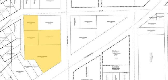
549 E Jefferson Blvd, Dallas, TX 75203

Property Detail
549 E Jefferson Blvd
00000252673000000
OAK CLIFF ORIGINAL BLK 107/3090 LTS 5 & 6 & PT LTS 4 & 7 ACS 1.72 INT202300038500 DD02282023 CO-DC 3090 107 00500 2DA3090 107
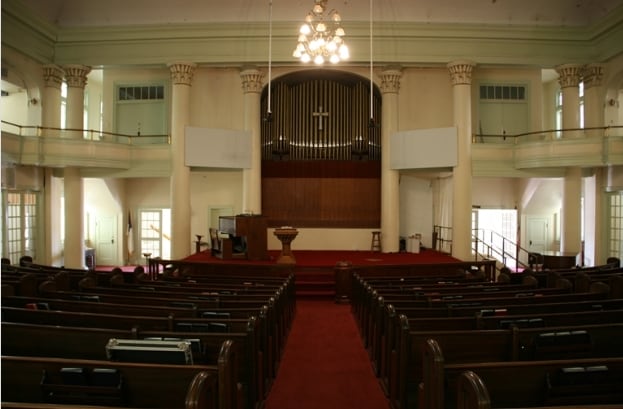
Religious
Dallas
Z248
Texas
B and X Area of moderate flood hazard, usually the area between the limits of the 100-year and 500-year floods.
5,6
2024
1.72 AC
2025
Southwest Dallas
004800
Dallas/Ft Worth
35,573 SF
Dallas-Fort Worth-Arlington, TX
NEARBY LISTINGS FOR SALE OR LEASE
DEMOGRAPHICS near 549 E Jefferson Blvd
1 mile
3 mile
5 mile
2025 Total Population
18,799
139,351
396,631
2030 Population
20,040
145,275
413,244
Pop Growth 2025-2030
+ 6.60%
+ 4.25%
+ 4.19%
Average Age
36
37
36
2025 Total Households
7,288
54,287
165,053
HH Growth 2025-2030
+ 6.83%
+ 4.93%
+ 4.56%
Median Household Inc
$59,475
$69,589
$68,936
Avg Household Size
2.50
2.40
2.30
2025 Avg HH Vehicles
2.00
2.00
2.00
Median Home Value
$370,833
$306,288
$283,912
Median Year Built
1969
1966
1984
Nearby Places
Map Layers
Map Styles
 Street
 Aerial
Transit
 Traffic
 Biking
Places
Listings with unknown addresses are not visible on the map
- Restaurants
- Banks
- Shops
- Fitness
- Groceries
PUBLIC TRANSPORTATION
TRANSIT/SUBWAY
Bishop Arts Station (DALLAS STREETCAR - Dallas Area Rapid Transit (DART))
Drive
Walk
Distance
Bishop Arts Station (DALLAS STREETCAR - Dallas Area Rapid Transit (DART))
2 min
12 min
0.6 mi
Dallas Zoo (Red Line - Dallas Area Rapid Transit (DART))
Drive
Walk
Distance
Dallas Zoo (Red Line - Dallas Area Rapid Transit (DART))
2 min
13 min
0.7 mi
6Th Streetcar Station (DALLAS STREETCAR - Dallas Area Rapid Transit (DART))
Drive
Walk
Distance
6Th Streetcar Station (DALLAS STREETCAR - Dallas Area Rapid Transit (DART))
2 min
16 min
0.8 mi
Oakenwald Streetcar Station (DALLAS STREETCAR - Dallas Area Rapid Transit (DART))
Drive
Walk
Distance
Oakenwald Streetcar Station (DALLAS STREETCAR - Dallas Area Rapid Transit (DART))
3 min
19 min
1.0 mi
COMMUTER RAIL
Victory Station (DART LIGHT RAIL - GREEN LINE - Dallas Area Rapid Transit (DART), DART LIGHT RAIL - ORANGE LINE - Dallas Area Rapid Transit (DART), TRINITY RAILWAY - Dallas Area Rapid Transit (DART))
Drive
Walk
Distance
Victory Station (DART LIGHT RAIL - GREEN LINE - Dallas Area Rapid Transit (DART), DART LIGHT RAIL - ORANGE LINE - Dallas Area Rapid Transit (DART), TRINITY RAILWAY - Dallas Area Rapid Transit (DART))
6 min
3.6 mi
Medical/Market Ctr Station (TRINITY RAILWAY - Dallas Area Rapid Transit (DART))
Drive
Walk
Distance
Medical/Market Ctr Station (TRINITY RAILWAY - Dallas Area Rapid Transit (DART))
10 min
6.1 mi
AIRPORT
Dallas Love Field
Drive
Walk
Distance
Dallas Love Field
16 min
8.5 mi
Dallas-Fort Worth International
Drive
Walk
Distance
Dallas-Fort Worth International
30 min
22.7 mi
Freight Ports
Port of Shreveport
Drive
Walk
Distance
Port of Shreveport
215 min
198.6 mi
Nearby Properties
Address
Land Use
TOTAL SIZE
Lot Size
Zoning
Address
Land Use
TOTAL SIZE
Lot Size
Zoning
1,298,826 SF
33.16 AC
Z163
Address
Land Use
TOTAL SIZE
Lot Size
Zoning
815,000 SF
7.20 AC
Z239
Address
Land Use
TOTAL SIZE
Lot Size
Zoning
1,676,176 SF
2.18 AC
Z239
Address
Land Use
TOTAL SIZE
Lot Size
Zoning
1,308,710 SF
8.42 AC
Z21
Address
Land Use
TOTAL SIZE
Lot Size
Zoning
1,480,246 SF
1.86 AC
Z21
Address
Land Use
TOTAL SIZE
Lot Size
Zoning
1,424,070 SF
1.36 AC
Z21
Address
Land Use
TOTAL SIZE
Lot Size
Zoning
893,159 SF
1.17 AC
Z21
Address
Land Use
TOTAL SIZE
Lot Size
Zoning
857,292 SF
1.47 AC
Z239
Address
Land Use
TOTAL SIZE
Lot Size
Zoning
638,046 SF
2.11 AC
Z239
Address
Land Use
TOTAL SIZE
Lot Size
Zoning
784,725 SF
2.33 AC
Z239
Address
Land Use
TOTAL SIZE
Lot Size
Zoning
180,000 SF
4.66 AC
Z116
Address
Land Use
TOTAL SIZE
Lot Size
Zoning
536,660 SF
2.02 AC
Z239
Address
Land Use
TOTAL SIZE
Lot Size
Zoning
1,848,034 SF
2.29 AC
Z21
Address
Land Use
TOTAL SIZE
Lot Size
Zoning
1,003,243 SF
2.07 AC
Z21
Address
Land Use
TOTAL SIZE
Lot Size
Zoning
858,120 SF
2.21 AC
Z21
Address
Land Use
TOTAL SIZE
Lot Size
Zoning
2,326,857 SF
4.43 AC
Z21
Address
Land Use
TOTAL SIZE
Lot Size
Zoning
539,723 SF
0.58 AC
Z239
Address
Land Use
TOTAL SIZE
Lot Size
Zoning
432,919 SF
0.69 AC
Z21
Address
Land Use
TOTAL SIZE
Lot Size
Zoning
1,912,762 SF
1.54 AC
Z21
Address
Land Use
TOTAL SIZE
Lot Size
Zoning
1,142,350 SF
1.37 AC
Z21
Address
Land Use
TOTAL SIZE
Lot Size
Zoning
1,979,594 SF
1.81 AC
Z21
Address
Land Use
TOTAL SIZE
Lot Size
Zoning
307,597 SF
15.21 AC
Z116
Address
Land Use
TOTAL SIZE
Lot Size
Zoning
1,173,721 SF
1.22 AC
Z21
Address
Land Use
TOTAL SIZE
Lot Size
Zoning
1,018,066 SF
1.20 AC
Z21
Address
Land Use
TOTAL SIZE
Lot Size
Zoning
741,673 SF
1.30 AC
Z21
Address
Land Use
TOTAL SIZE
Lot Size
Zoning
732,117 SF
5 AC
Z239
Address
Land Use
TOTAL SIZE
Lot Size
Zoning
464,405 SF
1.41 AC
Z21
Address
Land Use
TOTAL SIZE
Lot Size
Zoning
517,345 SF
2.02 AC
Z239
Address
Land Use
TOTAL SIZE
Lot Size
Zoning
600,907 SF
3.88 AC
Z239
Address
Land Use
TOTAL SIZE
Lot Size
Zoning
724,888 SF
2.59 AC
The World's #1 Commercial Real Estate Marketplace
Connect with us
© 2026 CoStar Group
The information above has been obtained from sources believed reliable. While we do not doubt its accuracy we have not verified it and make no guarantee, warranty or representation about it. It is your responsibility to independently confirm its accuracy and completeness. Any projections, opinions, assumptions, or estimates used are for example only and do not represent the current or future performance of the property. The value of this transaction to you depends on tax and other factors which should be evaluated by your tax, financial, and legal advisors. You and your advisors should conduct a careful, independent investigation of the property to determine to your satisfaction the suitability of the property for your needs.