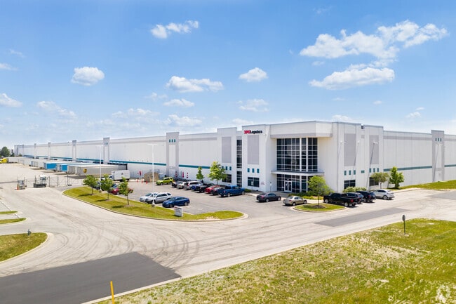
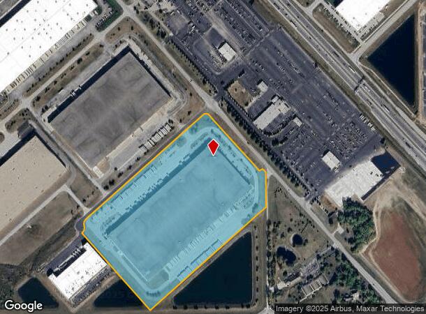
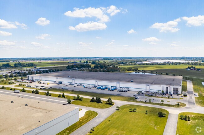
Property Record
5490 Industrial Ct, Whitestown, IN 46075
NEARBY LISTINGS FOR SALE OR LEASE
Property Detail
5490 Industrial Ct
Indianapolis-Carmel-Anderson, IN
Perry Industrial Pk 3 Sec 1
06-07-35-000-002.002-020
PERRY INDUSTRIAL PARK III SEC 1 LOT 1 & PT OF VACATED ROAD XPO LOGISTICS
Warehouse
Boone
X
Indiana
18011C0309E
1
2024
31.89 AC
2025
Far Boone County
810700
Indianapolis
628,206 SF
DEMOGRAPHICS near 5490 Industrial Ct
1 Mile
3 Mile
5 Mile
2024 Total Population
149
15,018
28,518
2029 Population
173
17,098
32,208
Pop Growth 2024-2029
+ 16.11%
+ 13.85%
+ 12.94%
Average Age
41
35
36
2024 Total Households
65
5,483
9,958
HH Growth 2024-2029
+ 15.38%
+ 14.26%
+ 13.23%
Median Household Inc
$89,583
$110,840
$118,448
Avg Household Size
2.30
2.70
2.90
2024 Avg HH Vehicles
2.00
2.00
2.00
Median Home Value
$269,565
$300,920
$354,775
Median Year Built
2006
2010
2007
Nearby Places
Map Layers
Map Styles
 Street
 Aerial
- Restaurants
- Banks
- Shops
- Fitness
- Groceries
PUBLIC TRANSPORTATION
AIRPORT
Indianapolis International
DRIVE
WALK
Distance
Indianapolis International
43 min
25.2 mi
Freight Ports
Port of Toledo
DRIVE
WALK
Distance
Port of Toledo
280 min
233.7 mi
SALE & LEASE HISTORY
LISTING DATE
SALE/LEASE

Feb 25, 2021
For Lease
Dec 09, 2019
For Lease
Nearby Properties
Address
Land Use
TOTAL SIZE
Lot Size
Zoning
Address
Land Use
TOTAL SIZE
Lot Size
Zoning
676 SF
69.72 AC
ZO01
Address
Land Use
TOTAL SIZE
Lot Size
Zoning
9,413 SF
27.40 AC
ZO01
Address
Land Use
TOTAL SIZE
Lot Size
Zoning
336 SF
52.76 AC
ZO01
Address
Land Use
TOTAL SIZE
Lot Size
Zoning
518 SF
95.61 AC
ZO01
Address
Land Use
TOTAL SIZE
Lot Size
Zoning
632,788 SF
59.27 AC
ZO01
Address
Land Use
TOTAL SIZE
Lot Size
Zoning
61.91 AC
ZO01
Address
Land Use
TOTAL SIZE
Lot Size
Zoning
44.11 AC
ZO01
Address
Land Use
TOTAL SIZE
Lot Size
Zoning
846,720 SF
58.21 AC
ZO01
Address
Land Use
TOTAL SIZE
Lot Size
Zoning
672,180 SF
32.90 AC
ZO01
Address
Land Use
TOTAL SIZE
Lot Size
Zoning
990 SF
21.78 AC
ZO01
Address
Land Use
TOTAL SIZE
Lot Size
Zoning
736,560 SF
54.22 AC
ZO01
Address
Land Use
TOTAL SIZE
Lot Size
Zoning
169,272 SF
23.93 AC
ZO01
Address
Land Use
TOTAL SIZE
Lot Size
Zoning
705,024 SF
39.27 AC
ZO01
Address
Land Use
TOTAL SIZE
Lot Size
Zoning
27,177 SF
12.23 AC
ZO01
Address
Land Use
TOTAL SIZE
Lot Size
Zoning
1,338 SF
51.66 AC
ZO01
Address
Land Use
TOTAL SIZE
Lot Size
Zoning
5,668 SF
19 AC
ZO01
Address
Land Use
TOTAL SIZE
Lot Size
Zoning
400,145 SF
31.94 AC
ZO01
Address
Land Use
TOTAL SIZE
Lot Size
Zoning
636,016 SF
51.41 AC
ZO01
Address
Land Use
TOTAL SIZE
Lot Size
Zoning
529,200 SF
19.46 AC
ZO01
Address
Land Use
TOTAL SIZE
Lot Size
Zoning
5,063 SF
12.50 AC
ZO01
Address
Land Use
TOTAL SIZE
Lot Size
Zoning
600,672 SF
33.21 AC
ZO01
Address
Land Use
TOTAL SIZE
Lot Size
Zoning
570,344 SF
33.79 AC
ZO01
Address
Land Use
TOTAL SIZE
Lot Size
Zoning
3,913 SF
13.09 AC
ZO01
Address
Land Use
TOTAL SIZE
Lot Size
Zoning
565,560 SF
35.19 AC
ZO01
Address
Land Use
TOTAL SIZE
Lot Size
Zoning
604,200 SF
42.93 AC
ZO01
Address
Land Use
TOTAL SIZE
Lot Size
Zoning
4,876 SF
10.60 AC
ZO01
Address
Land Use
TOTAL SIZE
Lot Size
Zoning
400,576 SF
42.69 AC
ZO01
Address
Land Use
TOTAL SIZE
Lot Size
Zoning
532,380 SF
28.26 AC
ZO01
Address
Land Use
TOTAL SIZE
Lot Size
Zoning
460,177 SF
27.85 AC
ZO01
The World's #1 Commercial Real Estate Marketplace
Connect with us
© 2025 CoStar Group
The information above has been obtained from sources believed reliable. While we do not doubt its accuracy we have not verified it and make no guarantee, warranty or representation about it. It is your responsibility to independently confirm its accuracy and completeness. Any projections, opinions, assumptions, or estimates used are for example only and do not represent the current or future performance of the property. The value of this transaction to you depends on tax and other factors which should be evaluated by your tax, financial, and legal advisors. You and your advisors should conduct a careful, independent investigation of the property to determine to your satisfaction the suitability of the property for your needs.