Property Record
54900 Romeo Plank Rd, Macomb, MI 48042


NEARBY LISTINGS FOR SALE OR LEASE
-
-
View all Macomb listings for sale on LoopNet.com
Property Detail
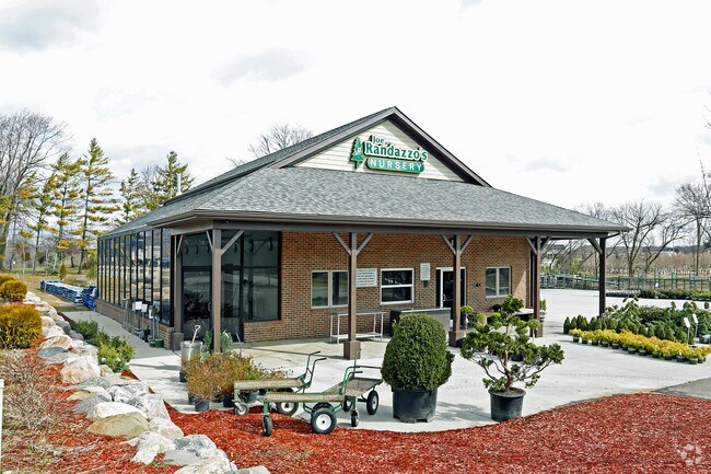
54900 Romeo Plank Rd
20-08-08-126-012
T3N, R13E, SEC 8; COMM AT NW COR SEC 8; TH N89*12'14"E 1527.18 FT, TH S03*12'41"E 201.87 FT TO POB; TH 89*34'30"E 382.54 FT,
Commercialnec
Macomb
AE
Michigan
26099C0230G
12.16 AC
2025
Macomb East
2025
Detroit
223803
Detroit-Warren-Dearborn, MI
1,872 SF
DEMOGRAPHICS near 54900 Romeo Plank Rd
1 Mile
3 Mile
5 Mile
2024 Total Population
11,142
44,565
129,272
2029 Population
11,023
44,140
127,692
Pop Growth 2024-2029
(1.07%)
(0.95%)
(1.22%)
Average Age
38
40
41
2024 Total Households
3,447
14,655
45,758
HH Growth 2024-2029
(1.19%)
(1.05%)
(1.32%)
Median Household Inc
$132,010
$127,375
$102,732
Avg Household Size
3.20
3.00
2.80
2024 Avg HH Vehicles
3.00
2.00
2.00
Median Home Value
$352,342
$364,187
$328,904
Median Year Built
2002
2000
1996
Nearby Places
Map Layers
Map Styles
 Street
 Aerial
- Restaurants
- Banks
- Shops
- Fitness
- Groceries
PUBLIC TRANSPORTATION
AIRPORT
Windsor International
DRIVE
WALK
Distance
Windsor International
71 min
44.0 mi
Freight Ports
Port of Toledo
DRIVE
WALK
Distance
Port of Toledo
121 min
94.6 mi
Nearby Properties
Address
Land Use
TOTAL SIZE
Lot Size
Zoning
Address
Land Use
TOTAL SIZE
Lot Size
Zoning
447,434 SF
23.29 AC
LM
Address
Land Use
TOTAL SIZE
Lot Size
Zoning
89,559 SF
44.54 AC
O2
Address
Land Use
TOTAL SIZE
Lot Size
Zoning
118,343 SF
7.33 AC
R1
Address
Land Use
TOTAL SIZE
Lot Size
Zoning
10.29 AC
LM
Address
Land Use
TOTAL SIZE
Lot Size
Zoning
160,104 SF
22.65 AC
CONSENT-R1
Address
Land Use
TOTAL SIZE
Lot Size
Zoning
90,185 SF
14.73 AC
C2
Address
Land Use
TOTAL SIZE
Lot Size
Zoning
79,942 SF
4.65 AC
M1
Address
Land Use
TOTAL SIZE
Lot Size
Zoning
120,658 SF
13.97 AC
C-3
Address
Land Use
TOTAL SIZE
Lot Size
Zoning
293,800 SF
M1
Address
Land Use
TOTAL SIZE
Lot Size
Zoning
108,799 SF
25.03 AC
CONSENT-R1
Address
Land Use
TOTAL SIZE
Lot Size
Zoning
214,282 SF
22.26 AC
M1
Address
Land Use
TOTAL SIZE
Lot Size
Zoning
150,854 SF
8.50 AC
LM
Address
Land Use
TOTAL SIZE
Lot Size
Zoning
148,438 SF
4.82 AC
LM
Address
Land Use
TOTAL SIZE
Lot Size
Zoning
99,619 SF
8.24 AC
M1
Address
Land Use
TOTAL SIZE
Lot Size
Zoning
74,354 SF
10.62 AC
C3
Address
Land Use
TOTAL SIZE
Lot Size
Zoning
37.96 AC
AG
Address
Land Use
TOTAL SIZE
Lot Size
Zoning
312,087 SF
25.65 AC
M1
Address
Land Use
TOTAL SIZE
Lot Size
Zoning
56,766 SF
5.06 AC
C2
Address
Land Use
TOTAL SIZE
Lot Size
Zoning
104,455 SF
15.28 AC
LM
Address
Land Use
TOTAL SIZE
Lot Size
Zoning
28,746 SF
10.70 AC
C3
Address
Land Use
TOTAL SIZE
Lot Size
Zoning
101,647 SF
5.48 AC
LM
Address
Land Use
TOTAL SIZE
Lot Size
Zoning
99,634 SF
4.75 AC
LM
Address
Land Use
TOTAL SIZE
Lot Size
Zoning
130,899 SF
2.03 AC
M1
Address
Land Use
TOTAL SIZE
Lot Size
Zoning
64,308 SF
7.63 AC
C-2
Address
Land Use
TOTAL SIZE
Lot Size
Zoning
85,760 SF
4.44 AC
LM
Address
Land Use
TOTAL SIZE
Lot Size
Zoning
92,056 SF
10.14 AC
LM
Address
Land Use
TOTAL SIZE
Lot Size
Zoning
103,800 SF
2.44 AC
M1
Address
Land Use
TOTAL SIZE
Lot Size
Zoning
68,513 SF
3.87 AC
M1
Address
Land Use
TOTAL SIZE
Lot Size
Zoning
68,520 SF
2.99 AC
LM
Address
Land Use
TOTAL SIZE
Lot Size
Zoning
66,578 SF
3.35 AC
M1
The World's #1 Commercial Real Estate Marketplace
Connect with us
© 2025 CoStar Group
The information above has been obtained from sources believed reliable. While we do not doubt its accuracy we have not verified it and make no guarantee, warranty or representation about it. It is your responsibility to independently confirm its accuracy and completeness. Any projections, opinions, assumptions, or estimates used are for example only and do not represent the current or future performance of the property. The value of this transaction to you depends on tax and other factors which should be evaluated by your tax, financial, and legal advisors. You and your advisors should conduct a careful, independent investigation of the property to determine to your satisfaction the suitability of the property for your needs.