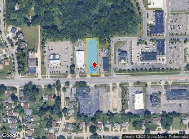
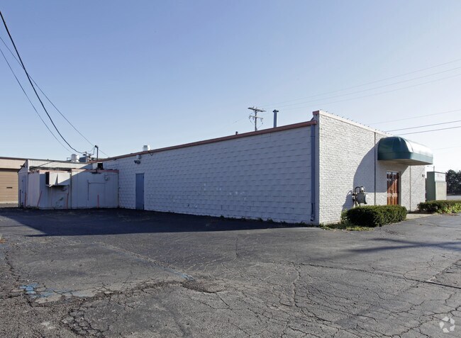
Property Record
5491 E 12 Mile Rd, Warren, MI 48092

NEARBY LISTINGS FOR SALE OR LEASE
Property Detail
5491 E 12 Mile Rd
12-13-08-476-002
T1N,R12E SEC 8 E 110.0 FT OF W 220.0 FT OF S 12 ACRESOF SE 1/4 OF SE 1/4 EXC S 60.0FT FOR HWY. 0.85 A
Bartavern
Macomb
X
Michigan
26099C0318G
0.85 AC
0
Macomb West
2025
Detroit
261000
Detroit-Warren-Dearborn, MI
2,720 SF
DEMOGRAPHICS near 5491 E 12 Mile Rd
1 Mile
3 Mile
5 Mile
2024 Total Population
8,576
107,948
323,146
2029 Population
8,530
106,544
319,734
Pop Growth 2024-2029
(0.54%)
(1.30%)
(1.06%)
Average Age
42
42
41
2024 Total Households
3,417
44,298
133,998
HH Growth 2024-2029
(0.38%)
(1.33%)
(1.06%)
Median Household Inc
$73,826
$58,079
$60,102
Avg Household Size
2.50
2.40
2.40
2024 Avg HH Vehicles
2.00
2.00
2.00
Median Home Value
$179,483
$161,517
$169,775
Median Year Built
1968
1964
1963
Nearby Places
Map Layers
Map Styles
 Street
 Aerial
- Restaurants
- Banks
- Shops
- Fitness
- Groceries
PUBLIC TRANSPORTATION
COMMUTER RAIL
DRIVE
WALK
Distance
12 min
7.8 mi
DRIVE
WALK
Distance
19 min
9.7 mi
AIRPORT
Windsor International
DRIVE
WALK
Distance
Windsor International
45 min
25.9 mi
Detroit Metro Wayne County
DRIVE
WALK
Distance
Detroit Metro Wayne County
49 min
35.5 mi
Nearby Properties
Address
Land Use
TOTAL SIZE
Lot Size
Zoning
Address
Land Use
TOTAL SIZE
Lot Size
Zoning
3,988,890 SF
223.80 AC
M-3
Address
Land Use
TOTAL SIZE
Lot Size
Zoning
1,727,664 SF
167.66 AC
M-3
Address
Land Use
TOTAL SIZE
Lot Size
Zoning
1,177,879 SF
104 AC
MZ
Address
Land Use
TOTAL SIZE
Lot Size
Zoning
1,596,307 SF
Address
Land Use
TOTAL SIZE
Lot Size
Zoning
1,107,643 SF
173.73 AC
MZ
Address
Land Use
TOTAL SIZE
Lot Size
Zoning
322,580 SF
Address
Land Use
TOTAL SIZE
Lot Size
Zoning
983,373 SF
60.16 AC
M-2
Address
Land Use
TOTAL SIZE
Lot Size
Zoning
910,140 SF
47.78 AC
Address
Land Use
TOTAL SIZE
Lot Size
Zoning
419,600 SF
Address
Land Use
TOTAL SIZE
Lot Size
Zoning
569,813 SF
62.54 AC
M-2
Address
Land Use
TOTAL SIZE
Lot Size
Zoning
207,605 SF
20.56 AC
PUD
Address
Land Use
TOTAL SIZE
Lot Size
Zoning
1,150,792 SF
53.17 AC
AD
Address
Land Use
TOTAL SIZE
Lot Size
Zoning
674,395 SF
33.13 AC
M-3
Address
Land Use
TOTAL SIZE
Lot Size
Zoning
226,380 SF
46.45 AC
M-1
Address
Land Use
TOTAL SIZE
Lot Size
Zoning
645 SF
23.16 AC
RM-2
Address
Land Use
TOTAL SIZE
Lot Size
Zoning
303,770 SF
23.62 AC
R-3
Address
Land Use
TOTAL SIZE
Lot Size
Zoning
228,421 SF
17.18 AC
RMMUL
Address
Land Use
TOTAL SIZE
Lot Size
Zoning
306,345 SF
Address
Land Use
TOTAL SIZE
Lot Size
Zoning
348,256 SF
46.10 AC
MZ
Address
Land Use
TOTAL SIZE
Lot Size
Zoning
146,981 SF
4.11 AC
Address
Land Use
TOTAL SIZE
Lot Size
Zoning
135,274 SF
20.55 AC
RM-2
Address
Land Use
TOTAL SIZE
Lot Size
Zoning
207,605 SF
19.39 AC
RETAIL5KSF
Address
Land Use
TOTAL SIZE
Lot Size
Zoning
378,412 SF
M1LT
Address
Land Use
TOTAL SIZE
Lot Size
Zoning
198,064 SF
11.11 AC
MZ
Address
Land Use
TOTAL SIZE
Lot Size
Zoning
1,261,658 SF
71.94 AC
M-2
Address
Land Use
TOTAL SIZE
Lot Size
Zoning
205,993 SF
19.90 AC
MZ
Address
Land Use
TOTAL SIZE
Lot Size
Zoning
243,132 SF
7.06 AC
C-2
Address
Land Use
TOTAL SIZE
Lot Size
Zoning
219,437 SF
18.80 AC
PCD
Address
Land Use
TOTAL SIZE
Lot Size
Zoning
233,900 SF
15.56 AC
M-2
Address
Land Use
TOTAL SIZE
Lot Size
Zoning
The World's #1 Commercial Real Estate Marketplace
Connect with us
© 2026 CoStar Group
The information above has been obtained from sources believed reliable. While we do not doubt its accuracy we have not verified it and make no guarantee, warranty or representation about it. It is your responsibility to independently confirm its accuracy and completeness. Any projections, opinions, assumptions, or estimates used are for example only and do not represent the current or future performance of the property. The value of this transaction to you depends on tax and other factors which should be evaluated by your tax, financial, and legal advisors. You and your advisors should conduct a careful, independent investigation of the property to determine to your satisfaction the suitability of the property for your needs.