Property Record
54Th St E, Puyallup, WA 98372
Property Detail
54Th St E
Seattle-Tacoma-Bellevue, WA
SECTION 22 TOWNSHIP 20 RANGE 04 QUARTER 24 : L 2 OF S P 79-162 EXC N 50 CYD TO P CO PER ETN 4408772 EXC POR APPROP PER P CO SUP CT CAUSE 14-2-13654-0 DESC AS FOLL S 37 FT OF W 46.64 FT EASE OF REC OUT OF 6-001 SEG 2017-0195 DX10/4/16DX DC00554345 2/1
042022-6027
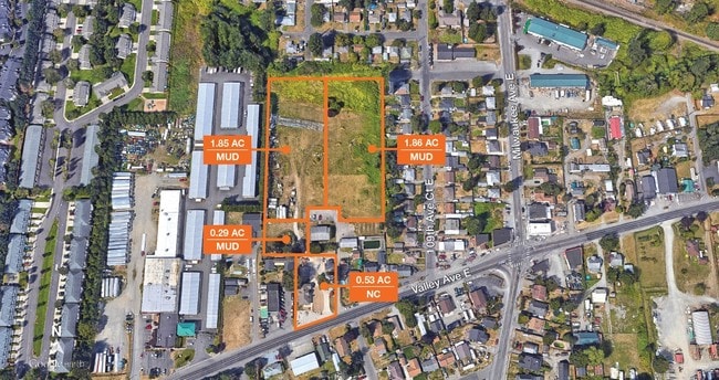
PIERCE
Vacantlandnec
Washington
MUD
2
AE The base floodplain where base flood elevations are provided. AE Zones are now used on new format FIRMs instead of A1-A30 Zones.
1.85 AC
2024
Tacoma Suburban
2025
Seattle/Puget Sound
940010
NEARBY LISTINGS FOR SALE OR LEASE
DEMOGRAPHICS near 54Th St E
1 mile
3 mile
5 mile
2025 Total Population
6,483
62,905
165,852
2030 Population
6,585
64,048
168,779
Pop Growth 2025-2030
+ 1.57%
+ 1.82%
+ 1.76%
Average Age
42
40
40
2025 Total Households
2,767
24,992
63,040
HH Growth 2025-2030
+ 1.70%
+ 1.84%
+ 1.76%
Median Household Inc
$99,214
$101,007
$105,014
Avg Household Size
2.30
2.50
2.60
2025 Avg HH Vehicles
2.00
2.00
2.00
Median Home Value
$588,541
$615,613
$605,694
Median Year Built
1984
1986
1989
Nearby Places
Map Layers
Map Styles
 Street
 Aerial
Layers
 Traffic
 Biking
Places
Listings with unknown addresses are not visible on the map
- Restaurants
- Banks
- Shops
- Fitness
- Groceries
PUBLIC TRANSPORTATION
COMMUTER RAIL
Tacoma Dome Station (Sounder South Line - Central Puget Sound Regional Transit Authority Rail (Link Light Rail/Sounder), Tacoma Link - Central Puget Sound Regional Transit Authority Rail (Link Light Rail/Sounder))
Drive
Walk
Distance
Tacoma Dome Station (Sounder South Line - Central Puget Sound Regional Transit Authority Rail (Link Light Rail/Sounder), Tacoma Link - Central Puget Sound Regional Transit Authority Rail (Link Light Rail/Sounder))
15 min
8.8 mi
AIRPORT
Seattle-Tacoma International
Drive
Walk
Distance
Seattle-Tacoma International
36 min
19.8 mi
Freight Ports
Port of Tacoma
Drive
Walk
Distance
Port of Tacoma
15 min
8.7 mi
SALE & LEASE HISTORY
LISTING DATE
SALE/LEASE

Nov 07, 2017
For Sale
May 02, 2018
For Sale
Feb 01, 2019
For Sale
Nearby Properties
Address
Land Use
TOTAL SIZE
Lot Size
Zoning
Address
Land Use
TOTAL SIZE
Lot Size
Zoning
925,611 SF
6.56 AC
Address
Land Use
TOTAL SIZE
Lot Size
Zoning
833,773 SF
94.01 AC
M1
Address
Land Use
TOTAL SIZE
Lot Size
Zoning
957,681 SF
56.53 AC
ML
Address
Land Use
TOTAL SIZE
Lot Size
Zoning
438,065 SF
20.43 AC
PUY
Address
Land Use
TOTAL SIZE
Lot Size
Zoning
321,680 SF
31.59 AC
RM
Address
Land Use
TOTAL SIZE
Lot Size
Zoning
648,679 SF
27.43 AC
M1
Address
Land Use
TOTAL SIZE
Lot Size
Zoning
425,832 SF
11 AC
RM-20
Address
Land Use
TOTAL SIZE
Lot Size
Zoning
Address
Land Use
TOTAL SIZE
Lot Size
Zoning
501,250 SF
29 AC
I
Address
Land Use
TOTAL SIZE
Lot Size
Zoning
311,800 SF
39.84 AC
FIFE
Address
Land Use
TOTAL SIZE
Lot Size
Zoning
506,925 SF
24.22 AC
M1
Address
Land Use
TOTAL SIZE
Lot Size
Zoning
521,674 SF
24.55 AC
M1
Address
Land Use
TOTAL SIZE
Lot Size
Zoning
255,871 SF
11.17 AC
EDGWD
Address
Land Use
TOTAL SIZE
Lot Size
Zoning
208,900 SF
8.72 AC
EDGWD
Address
Land Use
TOTAL SIZE
Lot Size
Zoning
452,600 SF
18.54 AC
I
Address
Land Use
TOTAL SIZE
Lot Size
Zoning
430,880 SF
23.46 AC
M1
Address
Land Use
TOTAL SIZE
Lot Size
Zoning
793,470 SF
50.76 AC
FAIR
Address
Land Use
TOTAL SIZE
Lot Size
Zoning
218,293 SF
12.20 AC
RM-20
Address
Land Use
TOTAL SIZE
Lot Size
Zoning
223,969 SF
16.97 AC
RM-20
Address
Land Use
TOTAL SIZE
Lot Size
Zoning
204,105 SF
10.67 AC
RM-20
Address
Land Use
TOTAL SIZE
Lot Size
Zoning
399,511 SF
18.34 AC
ML
Address
Land Use
TOTAL SIZE
Lot Size
Zoning
385,468 SF
18.22 AC
M1
Address
Land Use
TOTAL SIZE
Lot Size
Zoning
427,253 SF
18.46 AC
M1
Address
Land Use
TOTAL SIZE
Lot Size
Zoning
388,000 SF
23.48 AC
ML
Address
Land Use
TOTAL SIZE
Lot Size
Zoning
385,000 SF
19.10 AC
ML
Address
Land Use
TOTAL SIZE
Lot Size
Zoning
382,800 SF
19.15 AC
M1
Address
Land Use
TOTAL SIZE
Lot Size
Zoning
370,087 SF
15.61 AC
M1
Address
Land Use
TOTAL SIZE
Lot Size
Zoning
350,075 SF
16.66 AC
M1
Address
Land Use
TOTAL SIZE
Lot Size
Zoning
352,894 SF
20.11 AC
ML
Address
Land Use
TOTAL SIZE
Lot Size
Zoning
358,673 SF
14.84 AC
M1
The World's #1 Commercial Real Estate Marketplace
Connect with us
© 2026 CoStar Group
The information above has been obtained from sources believed reliable. While we do not doubt its accuracy we have not verified it and make no guarantee, warranty or representation about it. It is your responsibility to independently confirm its accuracy and completeness. Any projections, opinions, assumptions, or estimates used are for example only and do not represent the current or future performance of the property. The value of this transaction to you depends on tax and other factors which should be evaluated by your tax, financial, and legal advisors. You and your advisors should conduct a careful, independent investigation of the property to determine to your satisfaction the suitability of the property for your needs.