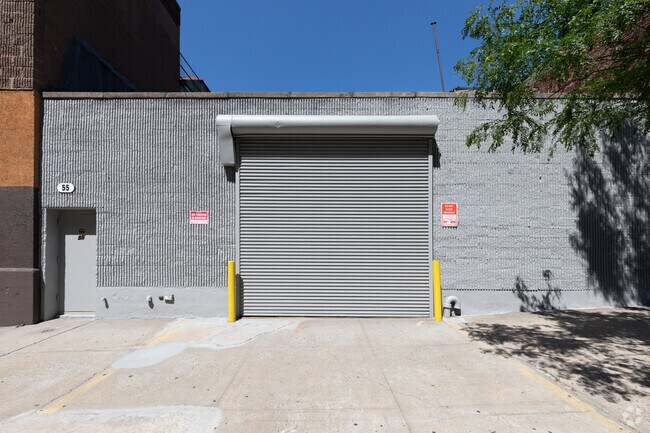
Property Record
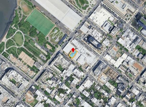
55 N 9Th St, Brooklyn, NY 11249
NEARBY LISTINGS FOR SALE OR LEASE
Property Detail
55 N 9Th St
02302-0041
DOCID-2022101100392002
Officebuilding
Kings
X
New York
3604970202F
41
2024
0.12 AC
2025
North Brooklyn
055700
Long Island (New York)
13,604 SF
New York-Jersey City-White Plains, NY-NJ
DEMOGRAPHICS near 55 N 9Th St
1 Mile
3 Mile
5 Mile
2024 Total Population
133,437
1,310,901
3,121,203
2029 Population
127,577
1,237,554
2,938,641
Pop Growth 2024-2029
(4.39%)
(5.60%)
(5.85%)
Average Age
37
38
39
2024 Total Households
60,925
600,112
1,370,597
HH Growth 2024-2029
(4.85%)
(5.99%)
(6.19%)
Median Household Inc
$104,063
$97,572
$92,028
Avg Household Size
2.10
2.10
2.20
2024 Avg HH Vehicles
.00
.00
.00
Median Home Value
$1,039,653
$967,482
$909,976
Median Year Built
1956
1953
1952
Nearby Places
- Restaurants
- Banks
- Shops
- Fitness
- Groceries
PUBLIC TRANSPORTATION
TRANSIT/SUBWAY
Bedford Avenue (L - New York MTA Subway (The Subway))
DRIVE
WALK
Distance
Bedford Avenue (L - New York MTA Subway (The Subway))
2 min
8 min
0.4 mi
Nassau Avenue (G - New York MTA Subway (The Subway))
DRIVE
WALK
Distance
Nassau Avenue (G - New York MTA Subway (The Subway))
3 min
12 min
0.6 mi
Metropolitan Avenue (G - New York MTA Subway (The Subway))
DRIVE
WALK
Distance
Metropolitan Avenue (G - New York MTA Subway (The Subway))
3 min
16 min
0.8 mi
Lorimer Street (L Line) (L - New York MTA Subway (The Subway))
DRIVE
WALK
Distance
Lorimer Street (L Line) (L - New York MTA Subway (The Subway))
3 min
16 min
0.8 mi
Greenpoint Avenue (G - New York MTA Subway (The Subway))
DRIVE
WALK
Distance
Greenpoint Avenue (G - New York MTA Subway (The Subway))
4 min
18 min
0.9 mi
COMMUTER RAIL
Hunterspoint Avenue Station (Hempstead Branch - Long Island Rail Road, Oyster Bay Branch - Long Island Rail Road)
DRIVE
WALK
Distance
Hunterspoint Avenue Station (Hempstead Branch - Long Island Rail Road, Oyster Bay Branch - Long Island Rail Road)
8 min
2.3 mi
Long Island City Station (Hempstead Branch - Long Island Rail Road)
DRIVE
WALK
Distance
Long Island City Station (Hempstead Branch - Long Island Rail Road)
8 min
2.5 mi
AIRPORT
LaGuardia
DRIVE
WALK
Distance
LaGuardia
17 min
7.4 mi
Newark Liberty International
DRIVE
WALK
Distance
Newark Liberty International
28 min
15.4 mi
John F Kennedy International
DRIVE
WALK
Distance
John F Kennedy International
26 min
15.6 mi
Freight Ports
NY - Red Hook Container Terminal
DRIVE
WALK
Distance
NY - Red Hook Container Terminal
11 min
5.5 mi
SALE & LEASE HISTORY
LISTING DATE
SALE/LEASE

Mar 02, 2022
For Sale
Dec 30, 2024
For Lease
Nearby Properties
Address
Land Use
TOTAL SIZE
Lot Size
Zoning
Address
Land Use
TOTAL SIZE
Lot Size
Zoning
2,245,112 SF
2.02 AC
C6-6
Address
Land Use
TOTAL SIZE
Lot Size
Zoning
1,783,434 SF
1.94 AC
C5-3
Address
Land Use
TOTAL SIZE
Lot Size
Zoning
8,462,176 SF
61.41 AC
R7-2
Address
Land Use
TOTAL SIZE
Lot Size
Zoning
2,636,182 SF
2.35 AC
C65.5
Address
Land Use
TOTAL SIZE
Lot Size
Zoning
2,161,994 SF
3.79 AC
M1-5
Address
Land Use
TOTAL SIZE
Lot Size
Zoning
2,354,289 SF
3.96 AC
C6-4
Address
Land Use
TOTAL SIZE
Lot Size
Zoning
2,734,038 SF
4.24 AC
C52.5
Address
Land Use
TOTAL SIZE
Lot Size
Zoning
1,678,135 SF
1.01 AC
C5-3
Address
Land Use
TOTAL SIZE
Lot Size
Zoning
1,897,491 SF
2.06 AC
C52.5
Address
Land Use
TOTAL SIZE
Lot Size
Zoning
2,812,739 SF
2.10 AC
C5-3
Address
Land Use
TOTAL SIZE
Lot Size
Zoning
1,642,675 SF
1.05 AC
C6-7
Address
Land Use
TOTAL SIZE
Lot Size
Zoning
1,984,228 SF
1.95 AC
C65.5
Address
Land Use
TOTAL SIZE
Lot Size
Zoning
1,048,620 SF
5.67 AC
C6-4
Address
Land Use
TOTAL SIZE
Lot Size
Zoning
1,586,876 SF
1.87 AC
C5-3
Address
Land Use
TOTAL SIZE
Lot Size
Zoning
1,962,900 SF
1.89 AC
C66.5
Address
Land Use
TOTAL SIZE
Lot Size
Zoning
1,946,157 SF
1.49 AC
C6-4
Address
Land Use
TOTAL SIZE
Lot Size
Zoning
2,535,958 SF
2.94 AC
C6-4
Address
Land Use
TOTAL SIZE
Lot Size
Zoning
1,613,847 SF
1.84 AC
C66.5
Address
Land Use
TOTAL SIZE
Lot Size
Zoning
2,344,406 SF
1.84 AC
C5-3
Address
Land Use
TOTAL SIZE
Lot Size
Zoning
1,805,894 SF
1.42 AC
C6-4
Address
Land Use
TOTAL SIZE
Lot Size
Zoning
2,157,862 SF
2.23 AC
BPC
Address
Land Use
TOTAL SIZE
Lot Size
Zoning
431,963 SF
C67T
Address
Land Use
TOTAL SIZE
Lot Size
Zoning
1,009,855 SF
4.90 AC
C6-3
Address
Land Use
TOTAL SIZE
Lot Size
Zoning
1,448,897 SF
1.56 AC
C6-6
Address
Land Use
TOTAL SIZE
Lot Size
Zoning
1,649,604 SF
1.51 AC
C67T
Address
Land Use
TOTAL SIZE
Lot Size
Zoning
2,400,000 SF
15.14 AC
C5-2
Address
Land Use
TOTAL SIZE
Lot Size
Zoning
2,255,659 SF
4.58 AC
BPC
Address
Land Use
TOTAL SIZE
Lot Size
Zoning
2,124,441 SF
17.29 AC
R8
Address
Land Use
TOTAL SIZE
Lot Size
Zoning
1,169,666 SF
1.42 AC
C52.5
Address
Land Use
TOTAL SIZE
Lot Size
Zoning
1,482,208 SF
1.71 AC
C5-3
The World's #1 Commercial Real Estate Marketplace
Connect with us
© 2025 CoStar Group
The information above has been obtained from sources believed reliable. While we do not doubt its accuracy we have not verified it and make no guarantee, warranty or representation about it. It is your responsibility to independently confirm its accuracy and completeness. Any projections, opinions, assumptions, or estimates used are for example only and do not represent the current or future performance of the property. The value of this transaction to you depends on tax and other factors which should be evaluated by your tax, financial, and legal advisors. You and your advisors should conduct a careful, independent investigation of the property to determine to your satisfaction the suitability of the property for your needs.