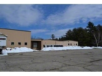
Property Record
55 Barnstead Rd, Pittsfield, NH 03263

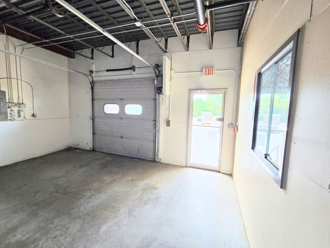
Current Lease Availabilities
Property Detail
55 Barnstead Rd
PTFD-000015-000000-000007-R000000
Merrimack
Industrialgeneral
New Hampshire
LIGHT
7
AE The base floodplain where base flood elevations are provided. AE Zones are now used on new format FIRMs instead of A1-A30 Zones.
11.20 AC
2025
Concord/New Hampshire North Area
2025
Other Market Areas
035000
Concord, NH
82,400 SF
NEARBY LISTINGS FOR SALE OR LEASE
DEMOGRAPHICS near 55 Barnstead Rd
1 mile
3 mile
5 mile
2025 Total Population
2,351
4,989
8,409
2030 Population
2,426
5,128
8,611
Pop Growth 2025-2030
+ 3.19%
+ 2.79%
+ 2.40%
Average Age
41
42
42
2025 Total Households
957
1,999
3,296
HH Growth 2025-2030
+ 3.13%
+ 2.75%
+ 2.37%
Median Household Inc
$64,107
$70,585
$85,100
Avg Household Size
2.40
2.40
2.50
2025 Avg HH Vehicles
2.00
2.00
2.00
Median Home Value
$307,487
$321,860
$342,260
Median Year Built
1975
1976
1979
Nearby Places
Map Layers
Map Styles
 Street
 Aerial
Layers
 Traffic
 Biking
Places
Listings with unknown addresses are not visible on the map
- Restaurants
- Banks
- Shops
- Fitness
- Groceries
PUBLIC TRANSPORTATION
AIRPORT
Manchester Boston Regional
Drive
Walk
Distance
Manchester Boston Regional
62 min
34.7 mi
Portsmouth International at Pease
Drive
Walk
Distance
Portsmouth International at Pease
63 min
35.5 mi
Nearby Properties
Address
Land Use
TOTAL SIZE
Lot Size
Zoning
Address
Land Use
TOTAL SIZE
Lot Size
Zoning
17 AC
SUBURB
Address
Land Use
TOTAL SIZE
Lot Size
Zoning
0.30 AC
LIGHT
Address
Land Use
TOTAL SIZE
Lot Size
Zoning
101 RE
Address
Land Use
TOTAL SIZE
Lot Size
Zoning
40,091 SF
42.44 AC
SUBURB
Address
Land Use
TOTAL SIZE
Lot Size
Zoning
81,117 SF
6.51 AC
LIGHT
Address
Land Use
TOTAL SIZE
Lot Size
Zoning
2.77 AC
URBAN
Address
Land Use
TOTAL SIZE
Lot Size
Zoning
6.64 AC
LIGHT
Address
Land Use
TOTAL SIZE
Lot Size
Zoning
2,943 SF
19.57 AC
RURAL
Address
Land Use
TOTAL SIZE
Lot Size
Zoning
47.20 AC
SUBURB
Address
Land Use
TOTAL SIZE
Lot Size
Zoning
67,900 SF
5 AC
LIGHT
Address
Land Use
TOTAL SIZE
Lot Size
Zoning
10.68 AC
LIGHT
Address
Land Use
TOTAL SIZE
Lot Size
Zoning
34,761 SF
5 AC
LIGHT
Address
Land Use
TOTAL SIZE
Lot Size
Zoning
5.21 AC
URBAN
Address
Land Use
TOTAL SIZE
Lot Size
Zoning
28,047 SF
1.07 AC
LIGHT
Address
Land Use
TOTAL SIZE
Lot Size
Zoning
8.68 AC
LIGHT
Address
Land Use
TOTAL SIZE
Lot Size
Zoning
Address
Land Use
TOTAL SIZE
Lot Size
Zoning
Address
Land Use
TOTAL SIZE
Lot Size
Zoning
11,084 SF
1.36 AC
LIGHT
Address
Land Use
TOTAL SIZE
Lot Size
Zoning
Address
Land Use
TOTAL SIZE
Lot Size
Zoning
5.54 AC
301 CO
Address
Land Use
TOTAL SIZE
Lot Size
Zoning
182.55 AC
RURAL
Address
Land Use
TOTAL SIZE
Lot Size
Zoning
16,050 SF
8.10 AC
LIGHT
Address
Land Use
TOTAL SIZE
Lot Size
Zoning
95 AC
RURAL
Address
Land Use
TOTAL SIZE
Lot Size
Zoning
19,364 SF
13.95 AC
LIGHT
Address
Land Use
TOTAL SIZE
Lot Size
Zoning
18 AC
RURAL
Address
Land Use
TOTAL SIZE
Lot Size
Zoning
9,960 SF
5.81 AC
COMM/I
Address
Land Use
TOTAL SIZE
Lot Size
Zoning
0.46 AC
COMMER
Address
Land Use
TOTAL SIZE
Lot Size
Zoning
9,626 SF
0.36 AC
COMMER
Address
Land Use
TOTAL SIZE
Lot Size
Zoning
2,138 SF
1.99 AC
LIGHT
The World's #1 Commercial Real Estate Marketplace
Connect with us
© 2026 CoStar Group
The information above has been obtained from sources believed reliable. While we do not doubt its accuracy we have not verified it and make no guarantee, warranty or representation about it. It is your responsibility to independently confirm its accuracy and completeness. Any projections, opinions, assumptions, or estimates used are for example only and do not represent the current or future performance of the property. The value of this transaction to you depends on tax and other factors which should be evaluated by your tax, financial, and legal advisors. You and your advisors should conduct a careful, independent investigation of the property to determine to your satisfaction the suitability of the property for your needs.