Property Record
55 Bartley Rd, Washington, NJ 07882
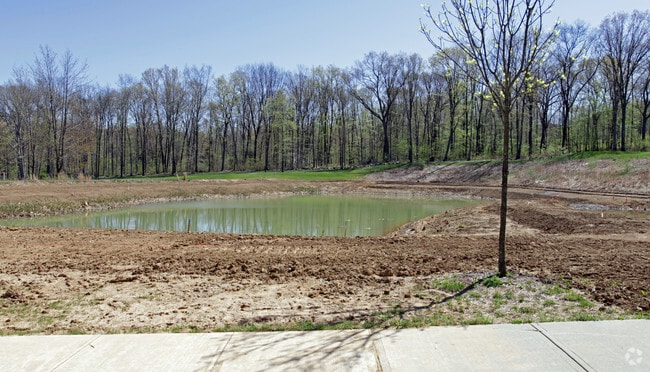

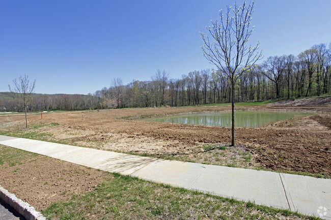
Property Detail
55 Bartley Rd
Newark, NJ
MORRIS
38-00018-0000-00022
New Jersey
Commercialnec
22
R-5
2.06 AC
2024
Western Morris
2025
Northern New Jersey
032000
NEARBY LISTINGS FOR SALE OR LEASE
DEMOGRAPHICS near 55 Bartley Rd
1 mile
3 mile
5 mile
2025 Total Population
973
12,827
43,034
2030 Population
986
13,094
43,743
Pop Growth 2025-2030
+ 1.34%
+ 2.08%
+ 1.65%
Average Age
43
43
42
2025 Total Households
342
4,502
15,507
HH Growth 2025-2030
+ 1.17%
+ 2.15%
+ 1.48%
Median Household Inc
$147,169
$167,528
$160,878
Avg Household Size
2.80
2.80
2.70
2025 Avg HH Vehicles
2.00
2.00
2.00
Median Home Value
$506,944
$625,661
$620,292
Median Year Built
1975
1974
1977
Nearby Places
Map Layers
Map Styles
 Street
 Aerial
Layers
 Traffic
 Biking
Places
Listings with unknown addresses are not visible on the map
- Restaurants
- Banks
- Shops
- Fitness
- Groceries
PUBLIC TRANSPORTATION
COMMUTER RAIL
Netcong (Montclair-Boonton Line - NJ Transit Commuter Rail (NJ Transit), Morris & Essex Morristown Line - NJ Transit Commuter Rail (NJ Transit))
Drive
Walk
Distance
Netcong (Montclair-Boonton Line - NJ Transit Commuter Rail (NJ Transit), Morris & Essex Morristown Line - NJ Transit Commuter Rail (NJ Transit))
17 min
8.7 mi
Gladstone (Morris & Essex Gladstone Branch - NJ Transit Commuter Rail (NJ Transit))
Drive
Walk
Distance
Gladstone (Morris & Essex Gladstone Branch - NJ Transit Commuter Rail (NJ Transit))
18 min
8.8 mi
AIRPORT
Newark Liberty International
Drive
Walk
Distance
Newark Liberty International
58 min
38.4 mi
Freight Ports
Maher Terminal
Drive
Walk
Distance
Maher Terminal
62 min
39.5 mi
Nearby Properties
Address
Land Use
TOTAL SIZE
Lot Size
Zoning
Address
Land Use
TOTAL SIZE
Lot Size
Zoning
242 AC
G-I
Address
Land Use
TOTAL SIZE
Lot Size
Zoning
21.56 AC
B-3
Address
Land Use
TOTAL SIZE
Lot Size
Zoning
50.50 AC
R-5
Address
Land Use
TOTAL SIZE
Lot Size
Zoning
104,682 SF
8.96 AC
B-3
Address
Land Use
TOTAL SIZE
Lot Size
Zoning
25.18 AC
R-5
Address
Land Use
TOTAL SIZE
Lot Size
Zoning
610.04 AC
R-5
Address
Land Use
TOTAL SIZE
Lot Size
Zoning
49,548 SF
19.99 AC
P
Address
Land Use
TOTAL SIZE
Lot Size
Zoning
81,865 SF
20.32 AC
C-2
Address
Land Use
TOTAL SIZE
Lot Size
Zoning
158,800 SF
18.40 AC
G-I
Address
Land Use
TOTAL SIZE
Lot Size
Zoning
65,914 SF
7.25 AC
B-3
Address
Land Use
TOTAL SIZE
Lot Size
Zoning
14.40 AC
R-1
Address
Land Use
TOTAL SIZE
Lot Size
Zoning
83,616 SF
36.79 AC
G-I
Address
Land Use
TOTAL SIZE
Lot Size
Zoning
1,516 SF
40.74 AC
R-LD
Address
Land Use
TOTAL SIZE
Lot Size
Zoning
3,328 SF
12.65 AC
B-2
Address
Land Use
TOTAL SIZE
Lot Size
Zoning
2,191 SF
5 AC
C-1
Address
Land Use
TOTAL SIZE
Lot Size
Zoning
3.41 AC
C1
Address
Land Use
TOTAL SIZE
Lot Size
Zoning
10,889 SF
2.40 AC
R-HD
Address
Land Use
TOTAL SIZE
Lot Size
Zoning
146 AC
P
Address
Land Use
TOTAL SIZE
Lot Size
Zoning
31,680 SF
3.23 AC
OP
Address
Land Use
TOTAL SIZE
Lot Size
Zoning
34.66 AC
R-5
Address
Land Use
TOTAL SIZE
Lot Size
Zoning
28,260 SF
2.84 AC
B-3
Address
Land Use
TOTAL SIZE
Lot Size
Zoning
5 AC
R-5
Address
Land Use
TOTAL SIZE
Lot Size
Zoning
22,907 SF
1.88 AC
C-2
Address
Land Use
TOTAL SIZE
Lot Size
Zoning
1,331 SF
7.44 AC
R-2
Address
Land Use
TOTAL SIZE
Lot Size
Zoning
44 AC
BE
Address
Land Use
TOTAL SIZE
Lot Size
Zoning
62,212 SF
5.50 AC
G-I
Address
Land Use
TOTAL SIZE
Lot Size
Zoning
15,040 SF
1.44 AC
B-3
Address
Land Use
TOTAL SIZE
Lot Size
Zoning
7,326 SF
11.91 AC
R-5
Address
Land Use
TOTAL SIZE
Lot Size
Zoning
47,124 SF
6 AC
G-I
Address
Land Use
TOTAL SIZE
Lot Size
Zoning
3,360 SF
2.04 AC
R-HD
The World's #1 Commercial Real Estate Marketplace
Connect with us
© 2026 CoStar Group
The information above has been obtained from sources believed reliable. While we do not doubt its accuracy we have not verified it and make no guarantee, warranty or representation about it. It is your responsibility to independently confirm its accuracy and completeness. Any projections, opinions, assumptions, or estimates used are for example only and do not represent the current or future performance of the property. The value of this transaction to you depends on tax and other factors which should be evaluated by your tax, financial, and legal advisors. You and your advisors should conduct a careful, independent investigation of the property to determine to your satisfaction the suitability of the property for your needs.