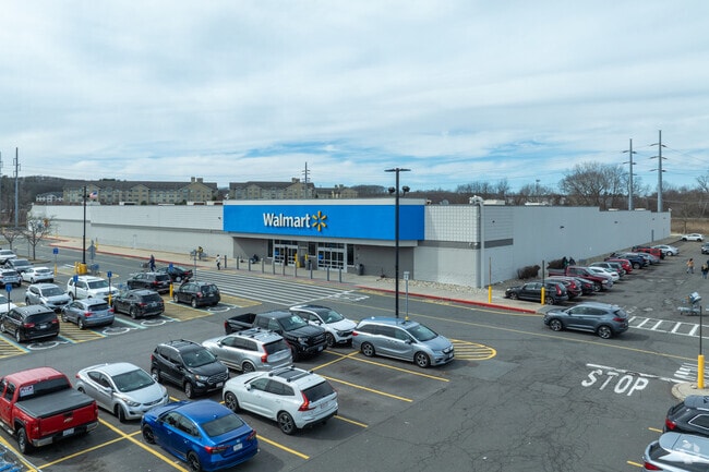
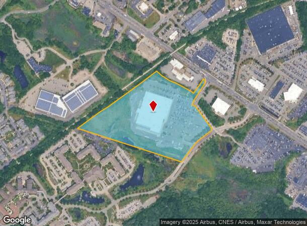
Property Record
55 Brooksby Village Way, Danvers, MA 01923
NEARBY LISTINGS FOR SALE OR LEASE
Property Detail
55 Brooksby Village Way
DANV-000056-000000-000008B
Essex
Departmentstore
Massachusetts
AE
8b
25009C0412G
19.75 AC
2025
Danvers/Beverly
2025
Boston
211402
Boston-Cambridge-Newton, MA-NH
122,145 SF
DEMOGRAPHICS near 55 Brooksby Village Way
1 Mile
3 Mile
5 Mile
2024 Total Population
9,153
68,324
188,238
2029 Population
9,164
67,986
187,152
Pop Growth 2024-2029
+ 0.12%
(0.49%)
(0.58%)
Average Age
53
45
43
2024 Total Households
4,686
27,956
76,418
HH Growth 2024-2029
+ 0.38%
(0.57%)
(0.73%)
Median Household Inc
$67,888
$91,561
$92,546
Avg Household Size
1.90
2.40
2.40
2024 Avg HH Vehicles
1.00
2.00
2.00
Median Home Value
$427,661
$527,084
$545,980
Median Year Built
1989
1968
1962
Nearby Places
Map Layers
Map Styles
 Street
 Aerial
- Restaurants
- Banks
- Shops
- Fitness
- Groceries
PUBLIC TRANSPORTATION
COMMUTER RAIL
Salem (Newburyport/Rockport Line - Massachusetts Bay Transportation Authority Commuter Rail (Purple Line))
DRIVE
WALK
Distance
Salem (Newburyport/Rockport Line - Massachusetts Bay Transportation Authority Commuter Rail (Purple Line))
13 min
5.0 mi
North Beverly (Newburyport/Rockport Line - Massachusetts Bay Transportation Authority Commuter Rail (Purple Line))
DRIVE
WALK
Distance
North Beverly (Newburyport/Rockport Line - Massachusetts Bay Transportation Authority Commuter Rail (Purple Line))
11 min
6.2 mi
AIRPORT
General Edward Lawrence Logan International
DRIVE
WALK
Distance
General Edward Lawrence Logan International
30 min
17.1 mi
Manchester Boston Regional
DRIVE
WALK
Distance
Manchester Boston Regional
71 min
43.5 mi
Nearby Properties
Address
Land Use
TOTAL SIZE
Lot Size
Zoning
Address
Land Use
TOTAL SIZE
Lot Size
Zoning
747,237 SF
36.70 AC
HW
Address
Land Use
TOTAL SIZE
Lot Size
Zoning
10,368 SF
33.83 AC
R3
Address
Land Use
TOTAL SIZE
Lot Size
Zoning
252,965 SF
56.44 AC
R3
Address
Land Use
TOTAL SIZE
Lot Size
Zoning
17 AC
R4
Address
Land Use
TOTAL SIZE
Lot Size
Zoning
198.74 AC
R3
Address
Land Use
TOTAL SIZE
Lot Size
Zoning
49 AC
I2
Address
Land Use
TOTAL SIZE
Lot Size
Zoning
17.60 AC
R1A
Address
Land Use
TOTAL SIZE
Lot Size
Zoning
13.04 AC
HC
Address
Land Use
TOTAL SIZE
Lot Size
Zoning
9.71 AC
BR
Address
Land Use
TOTAL SIZE
Lot Size
Zoning
49.85 AC
R1B
Address
Land Use
TOTAL SIZE
Lot Size
Zoning
65.79 AC
I1
Address
Land Use
TOTAL SIZE
Lot Size
Zoning
40.20 AC
R1B
Address
Land Use
TOTAL SIZE
Lot Size
Zoning
206.65 AC
R1B
Address
Land Use
TOTAL SIZE
Lot Size
Zoning
54,302 SF
83.70 AC
R3
Address
Land Use
TOTAL SIZE
Lot Size
Zoning
18.72 AC
R1
Address
Land Use
TOTAL SIZE
Lot Size
Zoning
11.08 AC
R4
Address
Land Use
TOTAL SIZE
Lot Size
Zoning
249,587 SF
5.79 AC
DDD
Address
Land Use
TOTAL SIZE
Lot Size
Zoning
59.99 AC
IP
Address
Land Use
TOTAL SIZE
Lot Size
Zoning
25.72 AC
IP
Address
Land Use
TOTAL SIZE
Lot Size
Zoning
408,207 SF
37.12 AC
C3
Address
Land Use
TOTAL SIZE
Lot Size
Zoning
28.30 AC
IP
Address
Land Use
TOTAL SIZE
Lot Size
Zoning
93,789 SF
8.22 AC
HW
Address
Land Use
TOTAL SIZE
Lot Size
Zoning
111.24 AC
R3
Address
Land Use
TOTAL SIZE
Lot Size
Zoning
24.37 AC
C3
Address
Land Use
TOTAL SIZE
Lot Size
Zoning
20.78 AC
C3
Address
Land Use
TOTAL SIZE
Lot Size
Zoning
19.10 AC
R114
Address
Land Use
TOTAL SIZE
Lot Size
Zoning
15.32 AC
HC
Address
Land Use
TOTAL SIZE
Lot Size
Zoning
71.68 AC
R3
Address
Land Use
TOTAL SIZE
Lot Size
Zoning
15.16 AC
I2
Address
Land Use
TOTAL SIZE
Lot Size
Zoning
158,572 SF
10 AC
I2
The World's #1 Commercial Real Estate Marketplace
Connect with us
© 2025 CoStar Group
The information above has been obtained from sources believed reliable. While we do not doubt its accuracy we have not verified it and make no guarantee, warranty or representation about it. It is your responsibility to independently confirm its accuracy and completeness. Any projections, opinions, assumptions, or estimates used are for example only and do not represent the current or future performance of the property. The value of this transaction to you depends on tax and other factors which should be evaluated by your tax, financial, and legal advisors. You and your advisors should conduct a careful, independent investigation of the property to determine to your satisfaction the suitability of the property for your needs.