Property Record
55 Cornell Ave, Lovelock, NV 89419
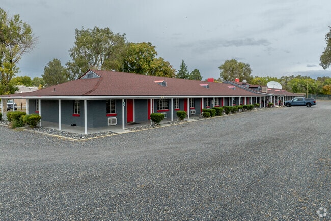

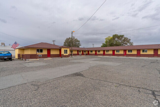
This Property Is For Sale
Property Detail
55 Cornell Ave
001-221-14
PARCEL 2 OF PM 123328 PTN NE1/4,CHANGED FROM PARCEL #007-241-28 (ANNEXED TO CITY),PARCEL 2-B PM 225932,CREATED FROM SPLIT OF PARCEL # 001-221-10,PARCEL 1 OF PM236500
Commercialnec
Pershing
C
Nevada
B and X Area of moderate flood hazard, usually the area between the limits of the 100-year and 500-year floods.
1
2024
4.26 AC
2025
Carson City/Nevada Area
960100
Other Market Areas
12,306 SF
NEARBY LISTINGS FOR SALE OR LEASE
DEMOGRAPHICS near 55 Cornell Ave
1 mile
3 mile
5 mile
2025 Total Population
1,250
2,578
3,985
2030 Population
1,164
2,454
3,852
Pop Growth 2025-2030
(6.88%)
(4.81%)
(3.34%)
Average Age
40
41
43
2025 Total Households
500
858
1,003
HH Growth 2025-2030
(6.80%)
(5.36%)
(4.99%)
Median Household Inc
$51,389
$65,378
$64,743
Avg Household Size
2.40
2.50
2.50
2025 Avg HH Vehicles
2.00
2.00
2.00
Median Home Value
$98,495
$116,265
$141,935
Median Year Built
1978
1980
1981
Nearby Places
Map Layers
Map Styles
 Street
 Aerial
Transit
 Traffic
 Biking
Places
Listings with unknown addresses are not visible on the map
- Restaurants
- Banks
- Shops
- Fitness
- Groceries
Nearby Properties
Address
Land Use
TOTAL SIZE
Lot Size
Zoning
Address
Land Use
TOTAL SIZE
Lot Size
Zoning
73,954 SF
13.75 AC
PSF
Address
Land Use
TOTAL SIZE
Lot Size
Zoning
124,432 SF
10.70 AC
PSF
Address
Land Use
TOTAL SIZE
Lot Size
Zoning
5,900 SF
4.05 AC
C
Address
Land Use
TOTAL SIZE
Lot Size
Zoning
9,090 SF
5.12 AC
I
Address
Land Use
TOTAL SIZE
Lot Size
Zoning
5,510 SF
5.54 AC
C
Address
Land Use
TOTAL SIZE
Lot Size
Zoning
9,360 SF
3.50 AC
MF
Address
Land Use
TOTAL SIZE
Lot Size
Zoning
12,591 SF
1,920.14 AC
GR
Address
Land Use
TOTAL SIZE
Lot Size
Zoning
32,622 SF
6.37 AC
PSF
Address
Land Use
TOTAL SIZE
Lot Size
Zoning
86,034 SF
3.36 AC
C
Address
Land Use
TOTAL SIZE
Lot Size
Zoning
26,872 SF
15 AC
GR
Address
Land Use
TOTAL SIZE
Lot Size
Zoning
13,851 SF
2.66 AC
SF
Address
Land Use
TOTAL SIZE
Lot Size
Zoning
18,057 SF
133.54 AC
GR
Address
Land Use
TOTAL SIZE
Lot Size
Zoning
28,512 SF
1.72 AC
MF
Address
Land Use
TOTAL SIZE
Lot Size
Zoning
598 SF
1.11 AC
MF
Address
Land Use
TOTAL SIZE
Lot Size
Zoning
8,000 SF
1.04 AC
GR
Address
Land Use
TOTAL SIZE
Lot Size
Zoning
16,500 SF
0.67 AC
Address
Land Use
TOTAL SIZE
Lot Size
Zoning
8,856 SF
1.32 AC
PSF
Address
Land Use
TOTAL SIZE
Lot Size
Zoning
16,694 SF
1.50 AC
MF
Address
Land Use
TOTAL SIZE
Lot Size
Zoning
5,766 SF
0.86 AC
C
Address
Land Use
TOTAL SIZE
Lot Size
Zoning
8,404 SF
1.67 AC
PSF
Address
Land Use
TOTAL SIZE
Lot Size
Zoning
5,934 SF
1.02 AC
MF
Address
Land Use
TOTAL SIZE
Lot Size
Zoning
8,940 SF
0.51 AC
PSF
Address
Land Use
TOTAL SIZE
Lot Size
Zoning
31,212 SF
4.33 AC
GC;GEN COM
Address
Land Use
TOTAL SIZE
Lot Size
Zoning
12,400 SF
2.50 AC
I
Address
Land Use
TOTAL SIZE
Lot Size
Zoning
9,460 SF
1.31 AC
PSF
Address
Land Use
TOTAL SIZE
Lot Size
Zoning
14,300 SF
2.07 AC
PSF
Address
Land Use
TOTAL SIZE
Lot Size
Zoning
25,472 SF
2.20 AC
I;INDUSTRI
Address
Land Use
TOTAL SIZE
Lot Size
Zoning
8,000 SF
0.03 AC
C
Address
Land Use
TOTAL SIZE
Lot Size
Zoning
15,742 SF
0.89 AC
C
The World's #1 Commercial Real Estate Marketplace
Connect with us
© 2026 CoStar Group
The information above has been obtained from sources believed reliable. While we do not doubt its accuracy we have not verified it and make no guarantee, warranty or representation about it. It is your responsibility to independently confirm its accuracy and completeness. Any projections, opinions, assumptions, or estimates used are for example only and do not represent the current or future performance of the property. The value of this transaction to you depends on tax and other factors which should be evaluated by your tax, financial, and legal advisors. You and your advisors should conduct a careful, independent investigation of the property to determine to your satisfaction the suitability of the property for your needs.