Property Record
55 County Route 59, Phoenix, NY 13135

NEARBY LISTINGS FOR SALE OR LEASE
-
-
View all Phoenix listings for sale on LoopNet.com
Property Detail
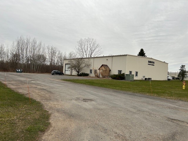
55 County Route 59
355489-303-000-0002-003-007-0000
Oswego
Manufacturinglight
New York
X
3.070
36075C0493G
1.52 AC
2025
Oswego County
2024
Syracuse
020905
Syracuse, NY
8,000 SF
DEMOGRAPHICS near 55 County Route 59
1 Mile
3 Mile
5 Mile
2024 Total Population
610
5,686
17,477
2029 Population
609
5,620
17,222
Pop Growth 2024-2029
(0.16%)
(1.16%)
(1.46%)
Average Age
42
42
44
2024 Total Households
262
2,347
7,344
HH Growth 2024-2029
(0.38%)
(1.19%)
(1.58%)
Median Household Inc
$63,000
$66,831
$72,555
Avg Household Size
2.30
2.40
2.30
2024 Avg HH Vehicles
2.00
2.00
2.00
Median Home Value
$154,917
$162,625
$186,241
Median Year Built
1971
1970
1981
Nearby Places
Map Layers
Map Styles
 Street
 Aerial
- Restaurants
- Banks
- Shops
- Fitness
- Groceries
PUBLIC TRANSPORTATION
AIRPORT
Syracuse Hancock International
DRIVE
WALK
Distance
Syracuse Hancock International
24 min
17.1 mi
Freight Ports
Albany, NY Port
DRIVE
WALK
Distance
Albany, NY Port
187 min
157.2 mi
SALE & LEASE HISTORY
LISTING DATE
SALE/LEASE

Oct 18, 2024
For Sale
Nearby Properties
Address
Land Use
TOTAL SIZE
Lot Size
Zoning
Address
Land Use
TOTAL SIZE
Lot Size
Zoning
16.02 AC
I
Address
Land Use
TOTAL SIZE
Lot Size
Zoning
126,699 SF
15.40 AC
R-1
Address
Land Use
TOTAL SIZE
Lot Size
Zoning
4,066 SF
34.38 AC
R-1
Address
Land Use
TOTAL SIZE
Lot Size
Zoning
108,066 SF
25.57 AC
R-1
Address
Land Use
TOTAL SIZE
Lot Size
Zoning
94,738 SF
32.90 AC
R-1
Address
Land Use
TOTAL SIZE
Lot Size
Zoning
2,520 SF
16.28 AC
FED
Address
Land Use
TOTAL SIZE
Lot Size
Zoning
6.98 AC
R-2
Address
Land Use
TOTAL SIZE
Lot Size
Zoning
3,600 SF
1.19 AC
IND
Address
Land Use
TOTAL SIZE
Lot Size
Zoning
4,483 SF
0.74 AC
B
Address
Land Use
TOTAL SIZE
Lot Size
Zoning
3,040 SF
5.03 AC
C-1
Address
Land Use
TOTAL SIZE
Lot Size
Zoning
65,320 SF
12.97 AC
C-1
Address
Land Use
TOTAL SIZE
Lot Size
Zoning
20,000 SF
4.35 AC
I
Address
Land Use
TOTAL SIZE
Lot Size
Zoning
8,859 SF
195.15 AC
R-3
Address
Land Use
TOTAL SIZE
Lot Size
Zoning
30,000 SF
34.12 AC
R-2
Address
Land Use
TOTAL SIZE
Lot Size
Zoning
92.69 AC
I-1
Address
Land Use
TOTAL SIZE
Lot Size
Zoning
6,880 SF
2.03 AC
C-1
Address
Land Use
TOTAL SIZE
Lot Size
Zoning
1.32 AC
R-2
Address
Land Use
TOTAL SIZE
Lot Size
Zoning
770 SF
92.28 AC
Address
Land Use
TOTAL SIZE
Lot Size
Zoning
198,000 SF
16.80 AC
I-1
Address
Land Use
TOTAL SIZE
Lot Size
Zoning
7,083 SF
2.52 AC
I
Address
Land Use
TOTAL SIZE
Lot Size
Zoning
13,552 SF
3.25 AC
R-1
Address
Land Use
TOTAL SIZE
Lot Size
Zoning
13,480 SF
5.20 AC
C-2
Address
Land Use
TOTAL SIZE
Lot Size
Zoning
7,000 SF
4.56 AC
I
Address
Land Use
TOTAL SIZE
Lot Size
Zoning
5,878 SF
4.17 AC
RM
Address
Land Use
TOTAL SIZE
Lot Size
Zoning
8,970 SF
7.03 AC
C-1
Address
Land Use
TOTAL SIZE
Lot Size
Zoning
7,392 SF
1.08 AC
R-2
Address
Land Use
TOTAL SIZE
Lot Size
Zoning
1,800 SF
24 AC
I
Address
Land Use
TOTAL SIZE
Lot Size
Zoning
2,604 SF
0.62 AC
B
Address
Land Use
TOTAL SIZE
Lot Size
Zoning
29.60 AC
Address
Land Use
TOTAL SIZE
Lot Size
Zoning
4,256 SF
1.45 AC
RM
The World's #1 Commercial Real Estate Marketplace
Connect with us
© 2025 CoStar Group
The information above has been obtained from sources believed reliable. While we do not doubt its accuracy we have not verified it and make no guarantee, warranty or representation about it. It is your responsibility to independently confirm its accuracy and completeness. Any projections, opinions, assumptions, or estimates used are for example only and do not represent the current or future performance of the property. The value of this transaction to you depends on tax and other factors which should be evaluated by your tax, financial, and legal advisors. You and your advisors should conduct a careful, independent investigation of the property to determine to your satisfaction the suitability of the property for your needs.