Property Record
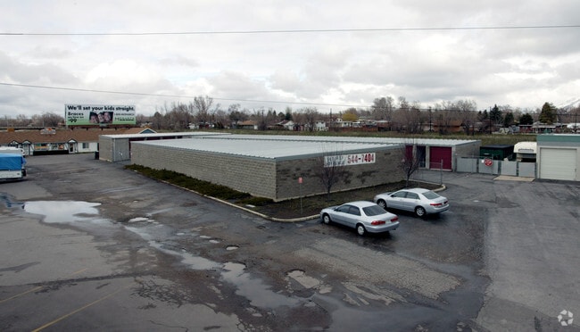
55 E Gentile St, Layton, UT 84041


Property Detail
55 E Gentile St
10-089-0081
A TRACT OF LAND SIT IN THE SW 1/4 SW 1/4 OF SEC 21-T4N-R1W, SLM; DESC AS FOLLOWS: BEG AT THE INTERSECTION OF THE SW'LY HWY R/W & NO-ACCESS LINE OF A HWY KNOWN AS INTERSTATE 15 & NW'LY LIMITED ACCESS
Storebuilding
Davis
CH
Utah
B and X Area of moderate flood hazard, usually the area between the limits of the 100-year and 500-year floods.
0.78 AC
2025
Davis North
2025
Salt Lake City
126001
Ogden, UT
4,219 SF
NEARBY LISTINGS FOR SALE OR LEASE
DEMOGRAPHICS near 55 E Gentile St
1 mile
3 mile
5 mile
2025 Total Population
13,900
95,389
177,243
2030 Population
14,300
98,642
184,865
Pop Growth 2025-2030
+ 2.88%
+ 3.41%
+ 4.30%
Average Age
36
36
35
2025 Total Households
4,680
30,199
54,446
HH Growth 2025-2030
+ 2.91%
+ 3.49%
+ 4.44%
Median Household Inc
$88,568
$105,163
$107,713
Avg Household Size
2.90
3.10
3.20
2025 Avg HH Vehicles
2.00
2.00
2.00
Median Home Value
$428,920
$532,483
$562,172
Median Year Built
1984
1992
1995
Nearby Places
Map Layers
Map Styles
 Street
 Aerial
Layers
 Traffic
 Biking
Places
Listings with unknown addresses are not visible on the map
- Restaurants
- Banks
- Shops
- Fitness
- Groceries
PUBLIC TRANSPORTATION
COMMUTER RAIL
Layton (FrontRunner North - Utah Transit Authority (UTA))
Drive
Walk
Distance
Layton (FrontRunner North - Utah Transit Authority (UTA))
1 min
8 min
0.4 mi
Clearfield (FrontRunner North - Utah Transit Authority (UTA))
Drive
Walk
Distance
Clearfield (FrontRunner North - Utah Transit Authority (UTA))
8 min
3.8 mi
AIRPORT
Salt Lake City International
Drive
Walk
Distance
Salt Lake City International
32 min
25.8 mi
Freight Ports
Port of Stockton
Drive
Walk
Distance
Port of Stockton
732 min
716.2 mi
Nearby Properties
Address
Land Use
TOTAL SIZE
Lot Size
Zoning
Address
Land Use
TOTAL SIZE
Lot Size
Zoning
346,223 SF
36.29 AC
BRP
Address
Land Use
TOTAL SIZE
Lot Size
Zoning
233,780 SF
14.77 AC
C-H
Address
Land Use
TOTAL SIZE
Lot Size
Zoning
17,930 SF
17.08 AC
RM1
Address
Land Use
TOTAL SIZE
Lot Size
Zoning
3,830 SF
16.64 AC
R3
Address
Land Use
TOTAL SIZE
Lot Size
Zoning
102,978 SF
6.42 AC
Address
Land Use
TOTAL SIZE
Lot Size
Zoning
100,348 SF
21.75 AC
R18
Address
Land Use
TOTAL SIZE
Lot Size
Zoning
348,048 SF
48.01 AC
A
Address
Land Use
TOTAL SIZE
Lot Size
Zoning
67,233 SF
32.52 AC
A1
Address
Land Use
TOTAL SIZE
Lot Size
Zoning
16,184 SF
23.31 AC
PU
Address
Land Use
TOTAL SIZE
Lot Size
Zoning
79,285 SF
0.01 AC
BRP
Address
Land Use
TOTAL SIZE
Lot Size
Zoning
86,536 SF
8.75 AC
Address
Land Use
TOTAL SIZE
Lot Size
Zoning
1,484 SF
10.34 AC
Address
Land Use
TOTAL SIZE
Lot Size
Zoning
94,532 SF
7.07 AC
Address
Land Use
TOTAL SIZE
Lot Size
Zoning
4,281 SF
16.55 AC
RM1
Address
Land Use
TOTAL SIZE
Lot Size
Zoning
147,675 SF
11.25 AC
C-H
Address
Land Use
TOTAL SIZE
Lot Size
Zoning
455,336 SF
22.93 AC
Address
Land Use
TOTAL SIZE
Lot Size
Zoning
111,724 SF
10.72 AC
RA
Address
Land Use
TOTAL SIZE
Lot Size
Zoning
75,946 SF
5.67 AC
CH
Address
Land Use
TOTAL SIZE
Lot Size
Zoning
182,344 SF
7.41 AC
CP-3
Address
Land Use
TOTAL SIZE
Lot Size
Zoning
107,628 SF
58.88 AC
A
Address
Land Use
TOTAL SIZE
Lot Size
Zoning
67,536 SF
13.16 AC
LI
Address
Land Use
TOTAL SIZE
Lot Size
Zoning
2,373 SF
6.63 AC
RM2PRUD
Address
Land Use
TOTAL SIZE
Lot Size
Zoning
104,342 SF
18.54 AC
M2
Address
Land Use
TOTAL SIZE
Lot Size
Zoning
6,591 SF
12.12 AC
R3
Address
Land Use
TOTAL SIZE
Lot Size
Zoning
38,832 SF
6.82 AC
CP2
Address
Land Use
TOTAL SIZE
Lot Size
Zoning
140,364 SF
6.47 AC
RH
Address
Land Use
TOTAL SIZE
Lot Size
Zoning
218,896 SF
2.76 AC
MUTOD
Address
Land Use
TOTAL SIZE
Lot Size
Zoning
119,988 SF
10.63 AC
LI
Address
Land Use
TOTAL SIZE
Lot Size
Zoning
1,679 SF
7.49 AC
RM2
Address
Land Use
TOTAL SIZE
Lot Size
Zoning
176,970 SF
13.58 AC
CP3
The World's #1 Commercial Real Estate Marketplace
Connect with us
© 2026 CoStar Group
The information above has been obtained from sources believed reliable. While we do not doubt its accuracy we have not verified it and make no guarantee, warranty or representation about it. It is your responsibility to independently confirm its accuracy and completeness. Any projections, opinions, assumptions, or estimates used are for example only and do not represent the current or future performance of the property. The value of this transaction to you depends on tax and other factors which should be evaluated by your tax, financial, and legal advisors. You and your advisors should conduct a careful, independent investigation of the property to determine to your satisfaction the suitability of the property for your needs.