Property Record
55 E Warner Rd, Gilbert, AZ 85296
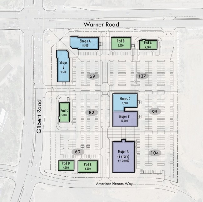

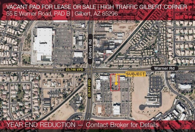
Current Lease Availabilities
Property Detail
55 E Warner Rd
Phoenix-Mesa-Chandler, AZ
GILBERT AND WARNER TOWN CENTER MCR 1467-46
313-12-910
MARICOPA
Parkinglot
Arizona
R3
2
AH Areas with a 1% annual chance of shallow flooding, usually in the form of a pond, withan average depth ranging from 1 to 3 feet. These areas have a 26% chance of flooding over the life of a 30-year mortgage.
1.71 AC
2025
Chandler
2025
Phoenix
814600
NEARBY LISTINGS FOR SALE OR LEASE
DEMOGRAPHICS near 55 E Warner Rd
1 mile
3 mile
5 mile
2024 Total Population
15,747
128,723
352,109
2029 Population
16,956
138,615
379,975
Pop Growth 2024-2029
+ 7.68%
+ 7.68%
+ 7.91%
Average Age
38
37
36
2024 Total Households
5,634
45,350
123,697
HH Growth 2024-2029
+ 7.76%
+ 7.80%
+ 8.01%
Median Household Inc
$99,779
$98,755
$91,103
Avg Household Size
2.80
2.80
2.80
2024 Avg HH Vehicles
2.00
2.00
2.00
Median Home Value
$414,587
$412,963
$394,048
Median Year Built
1995
1994
1993
Nearby Places
Map Layers
Map Styles
 Street
 Aerial
Transit
 Traffic
 Biking
Places
Listings with unknown addresses are not visible on the map
- Restaurants
- Banks
- Shops
- Fitness
- Groceries
PUBLIC TRANSPORTATION
AIRPORT
Phoenix-Mesa Gateway
Drive
Walk
Distance
Phoenix-Mesa Gateway
17 min
8.9 mi
Phoenix Sky Harbor International
Drive
Walk
Distance
Phoenix Sky Harbor International
31 min
20.3 mi
Freight Ports
Port of San Diego
Drive
Walk
Distance
Port of San Diego
410 min
371.1 mi
Nearby Properties
Address
Land Use
TOTAL SIZE
Lot Size
Zoning
Address
Land Use
TOTAL SIZE
Lot Size
Zoning
301,190 SF
77.17 AC
PF
Address
Land Use
TOTAL SIZE
Lot Size
Zoning
9.25 AC
I-1
Address
Land Use
TOTAL SIZE
Lot Size
Zoning
479,727 SF
14.25 AC
MFM
Address
Land Use
TOTAL SIZE
Lot Size
Zoning
290,450 SF
38.47 AC
PF
Address
Land Use
TOTAL SIZE
Lot Size
Zoning
300,885 SF
37.63 AC
AG
Address
Land Use
TOTAL SIZE
Lot Size
Zoning
387,535 SF
15.80 AC
C-G
Address
Land Use
TOTAL SIZE
Lot Size
Zoning
380,383 SF
14.79 AC
C-G
Address
Land Use
TOTAL SIZE
Lot Size
Zoning
112,628 SF
17.37 AC
I-1
Address
Land Use
TOTAL SIZE
Lot Size
Zoning
309,031 SF
18.55 AC
Address
Land Use
TOTAL SIZE
Lot Size
Zoning
16.57 AC
PF
Address
Land Use
TOTAL SIZE
Lot Size
Zoning
372,953 SF
14.36 AC
C-C
Address
Land Use
TOTAL SIZE
Lot Size
Zoning
16,133 SF
1.79 AC
PF
Address
Land Use
TOTAL SIZE
Lot Size
Zoning
267,868 SF
13.18 AC
R-CH
Address
Land Use
TOTAL SIZE
Lot Size
Zoning
357,691 SF
19.87 AC
PAD
Address
Land Use
TOTAL SIZE
Lot Size
Zoning
238,856 SF
6.53 AC
R3
Address
Land Use
TOTAL SIZE
Lot Size
Zoning
7,418 SF
2.37 AC
C-G
Address
Land Use
TOTAL SIZE
Lot Size
Zoning
237,329 SF
9.76 AC
C-N
Address
Land Use
TOTAL SIZE
Lot Size
Zoning
115,920 SF
18.19 AC
Address
Land Use
TOTAL SIZE
Lot Size
Zoning
154,816 SF
35.89 AC
I-1
Address
Land Use
TOTAL SIZE
Lot Size
Zoning
270,243 SF
15.52 AC
M-M
Address
Land Use
TOTAL SIZE
Lot Size
Zoning
131,003 SF
12.80 AC
PF
Address
Land Use
TOTAL SIZE
Lot Size
Zoning
229,536 SF
13.94 AC
PAD
Address
Land Use
TOTAL SIZE
Lot Size
Zoning
222,882 SF
16.13 AC
PAD
Address
Land Use
TOTAL SIZE
Lot Size
Zoning
90,920 SF
2.27 AC
C-O
Address
Land Use
TOTAL SIZE
Lot Size
Zoning
82,212 SF
40 AC
PF
Address
Land Use
TOTAL SIZE
Lot Size
Zoning
3.83 AC
C-C
Address
Land Use
TOTAL SIZE
Lot Size
Zoning
93,287 SF
29.54 AC
PF
Address
Land Use
TOTAL SIZE
Lot Size
Zoning
69,974 SF
40 AC
AG
Address
Land Use
TOTAL SIZE
Lot Size
Zoning
312,526 SF
14.17 AC
PAD
Address
Land Use
TOTAL SIZE
Lot Size
Zoning
230,826 SF
25.95 AC
PAD
The World's #1 Commercial Real Estate Marketplace
Connect with us
© 2026 CoStar Group
The information above has been obtained from sources believed reliable. While we do not doubt its accuracy we have not verified it and make no guarantee, warranty or representation about it. It is your responsibility to independently confirm its accuracy and completeness. Any projections, opinions, assumptions, or estimates used are for example only and do not represent the current or future performance of the property. The value of this transaction to you depends on tax and other factors which should be evaluated by your tax, financial, and legal advisors. You and your advisors should conduct a careful, independent investigation of the property to determine to your satisfaction the suitability of the property for your needs.