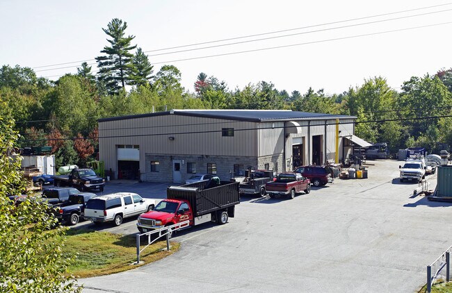
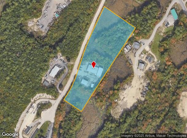
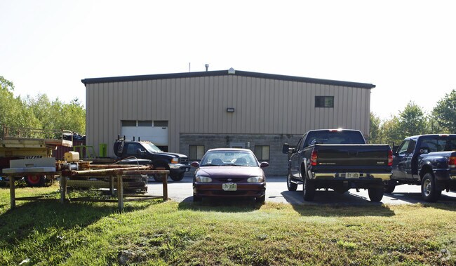
Property Record
55 Gold Ledge Ave, Auburn, NH 03032
NEARBY LISTINGS FOR SALE OR LEASE
-
-
View all Auburn listings for sale on LoopNet.com
Property Detail
55 Gold Ledge Ave
AUBR-000001-000018-000002
Rockingham
Commercialnec
New Hampshire
X
2
33015C0328E
5.85 AC
2024
Rockingham
2024
Boston
004000
Boston-Cambridge-Newton, MA-NH
11,013 SF
DEMOGRAPHICS near 55 Gold Ledge Ave
1 Mile
3 Mile
5 Mile
2024 Total Population
738
14,358
64,791
2029 Population
768
14,994
66,556
Pop Growth 2024-2029
+ 4.07%
+ 4.43%
+ 2.72%
Average Age
40
41
41
2024 Total Households
253
5,379
25,839
HH Growth 2024-2029
+ 4.35%
+ 4.41%
+ 2.63%
Median Household Inc
$142,499
$111,909
$91,010
Avg Household Size
2.90
2.60
2.40
2024 Avg HH Vehicles
3.00
2.00
2.00
Median Home Value
$569,820
$398,972
$346,760
Median Year Built
1981
1989
1977
Nearby Places
Map Layers
Map Styles
 Street
 Aerial
- Restaurants
- Banks
- Shops
- Fitness
- Groceries
PUBLIC TRANSPORTATION
AIRPORT
Manchester Boston Regional
DRIVE
WALK
Distance
Manchester Boston Regional
23 min
10.1 mi
Portsmouth International at Pease
DRIVE
WALK
Distance
Portsmouth International at Pease
63 min
46.2 mi
Freight Ports
Port of Boston
DRIVE
WALK
Distance
Port of Boston
68 min
50.1 mi
Nearby Properties
Address
Land Use
TOTAL SIZE
Lot Size
Zoning
Address
Land Use
TOTAL SIZE
Lot Size
Zoning
8,064 SF
34.29 AC
Address
Land Use
TOTAL SIZE
Lot Size
Zoning
366,008 SF
41.69 AC
IND-I
Address
Land Use
TOTAL SIZE
Lot Size
Zoning
487,970 SF
79.74 AC
IND-I
Address
Land Use
TOTAL SIZE
Lot Size
Zoning
119,139 SF
25.87 AC
IND-I
Address
Land Use
TOTAL SIZE
Lot Size
Zoning
6 AC
RURAL
Address
Land Use
TOTAL SIZE
Lot Size
Zoning
125,060 SF
8.76 AC
IND-I
Address
Land Use
TOTAL SIZE
Lot Size
Zoning
156,000 SF
19.19 AC
Address
Land Use
TOTAL SIZE
Lot Size
Zoning
Address
Land Use
TOTAL SIZE
Lot Size
Zoning
722 SF
65 AC
Address
Land Use
TOTAL SIZE
Lot Size
Zoning
56,769 SF
20.09 AC
Address
Land Use
TOTAL SIZE
Lot Size
Zoning
133,900 SF
Address
Land Use
TOTAL SIZE
Lot Size
Zoning
13.67 AC
R-III
Address
Land Use
TOTAL SIZE
Lot Size
Zoning
952 SF
199 AC
AR-I
Address
Land Use
TOTAL SIZE
Lot Size
Zoning
160,452 SF
20.44 AC
Address
Land Use
TOTAL SIZE
Lot Size
Zoning
768 SF
1.90 AC
Address
Land Use
TOTAL SIZE
Lot Size
Zoning
104.90 AC
Address
Land Use
TOTAL SIZE
Lot Size
Zoning
106,200 SF
3.55 AC
C-II
Address
Land Use
TOTAL SIZE
Lot Size
Zoning
62,164 SF
25.47 AC
IND-I
Address
Land Use
TOTAL SIZE
Lot Size
Zoning
113.28 AC
Address
Land Use
TOTAL SIZE
Lot Size
Zoning
91,360 SF
Address
Land Use
TOTAL SIZE
Lot Size
Zoning
40,974 SF
4.73 AC
C-II
Address
Land Use
TOTAL SIZE
Lot Size
Zoning
7,414 SF
5.32 AC
Address
Land Use
TOTAL SIZE
Lot Size
Zoning
2,866 SF
3.57 AC
Address
Land Use
TOTAL SIZE
Lot Size
Zoning
56,000 SF
5.93 AC
Address
Land Use
TOTAL SIZE
Lot Size
Zoning
106,008 SF
7.80 AC
Address
Land Use
TOTAL SIZE
Lot Size
Zoning
52,711 SF
4.23 AC
Address
Land Use
TOTAL SIZE
Lot Size
Zoning
15,080 SF
9.18 AC
C-II
Address
Land Use
TOTAL SIZE
Lot Size
Zoning
73,640 SF
7.87 AC
Address
Land Use
TOTAL SIZE
Lot Size
Zoning
50.27 AC
I-II
Address
Land Use
TOTAL SIZE
Lot Size
Zoning
46,460 SF
6.55 AC
IND-II
The World's #1 Commercial Real Estate Marketplace
Connect with us
© 2026 CoStar Group
The information above has been obtained from sources believed reliable. While we do not doubt its accuracy we have not verified it and make no guarantee, warranty or representation about it. It is your responsibility to independently confirm its accuracy and completeness. Any projections, opinions, assumptions, or estimates used are for example only and do not represent the current or future performance of the property. The value of this transaction to you depends on tax and other factors which should be evaluated by your tax, financial, and legal advisors. You and your advisors should conduct a careful, independent investigation of the property to determine to your satisfaction the suitability of the property for your needs.