Property Record
55 Guerrant St, Umatilla, FL 32784
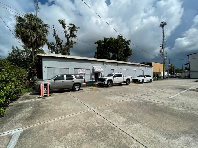


This Property Is For Sale
NEARBY LISTINGS FOR SALE OR LEASE
Property Detail
55 Guerrant St
Orlando-Kissimmee-Sanford, FL
Yanceys Add
13-18-26-1200-00H-00100
UMATILLA YANCEYS ADD WLY 45 FT OF LOT 1 WLY 45 FT OF N 47 FT OF LOT 2 BLK H PB 1 PG 30 ORB 6462 PG 2459
Retailwithmorethanonenonretailuse
Lake
X
Florida
12069C0220E
1
2024
0.11 AC
2026
Lake County
030110
Orlando
3,200 SF
DEMOGRAPHICS near 55 Guerrant St
1 Mile
3 Mile
5 Mile
2024 Total Population
3,538
10,356
25,385
2029 Population
4,692
13,733
33,548
Pop Growth 2024-2029
+ 32.62%
+ 32.61%
+ 32.16%
Average Age
43
44
43
2024 Total Households
1,470
4,220
10,331
HH Growth 2024-2029
+ 32.86%
+ 32.91%
+ 32.39%
Median Household Inc
$66,039
$69,301
$69,575
Avg Household Size
2.40
2.40
2.40
2024 Avg HH Vehicles
2.00
2.00
2.00
Median Home Value
$257,341
$290,949
$288,956
Median Year Built
1983
1986
1987
Nearby Places
Map Layers
Map Styles
 Street
 Aerial
- Restaurants
- Banks
- Shops
- Fitness
- Groceries
PUBLIC TRANSPORTATION
AIRPORT
Orlando Sanford International
DRIVE
WALK
Distance
Orlando Sanford International
63 min
40.4 mi
Freight Ports
Port Canaveral
DRIVE
WALK
Distance
Port Canaveral
123 min
98.5 mi
Nearby Properties
Address
Land Use
TOTAL SIZE
Lot Size
Zoning
Address
Land Use
TOTAL SIZE
Lot Size
Zoning
601,069 SF
110.90 AC
CFD
Address
Land Use
TOTAL SIZE
Lot Size
Zoning
1,486.45 AC
A
Address
Land Use
TOTAL SIZE
Lot Size
Zoning
19,830 SF
69.88 AC
R3
Address
Land Use
TOTAL SIZE
Lot Size
Zoning
494,946 SF
57.60 AC
LM
Address
Land Use
TOTAL SIZE
Lot Size
Zoning
63,848 SF
6.80 AC
PFD
Address
Land Use
TOTAL SIZE
Lot Size
Zoning
2,000 SF
16.13 AC
PFD
Address
Land Use
TOTAL SIZE
Lot Size
Zoning
113,572 SF
21.17 AC
LM
Address
Land Use
TOTAL SIZE
Lot Size
Zoning
50,654 SF
9.83 AC
PFD
Address
Land Use
TOTAL SIZE
Lot Size
Zoning
71.58 AC
Address
Land Use
TOTAL SIZE
Lot Size
Zoning
90,584 SF
11.14 AC
HM
Address
Land Use
TOTAL SIZE
Lot Size
Zoning
60,034 SF
73.32 AC
AR
Address
Land Use
TOTAL SIZE
Lot Size
Zoning
48,132 SF
9.50 AC
C2
Address
Land Use
TOTAL SIZE
Lot Size
Zoning
2,000 SF
21.14 AC
PFD
Address
Land Use
TOTAL SIZE
Lot Size
Zoning
776.54 AC
A
Address
Land Use
TOTAL SIZE
Lot Size
Zoning
2,000 SF
28.22 AC
PFD
Address
Land Use
TOTAL SIZE
Lot Size
Zoning
40,130 SF
4.88 AC
R6
Address
Land Use
TOTAL SIZE
Lot Size
Zoning
24,800 SF
13.08 AC
Address
Land Use
TOTAL SIZE
Lot Size
Zoning
24,000 SF
2.67 AC
Address
Land Use
TOTAL SIZE
Lot Size
Zoning
14,012 SF
2.25 AC
RP
Address
Land Use
TOTAL SIZE
Lot Size
Zoning
11,704 SF
24.50 AC
HM
Address
Land Use
TOTAL SIZE
Lot Size
Zoning
31,651 SF
3.20 AC
RR
Address
Land Use
TOTAL SIZE
Lot Size
Zoning
25,077 SF
3.82 AC
LM
Address
Land Use
TOTAL SIZE
Lot Size
Zoning
20,382 SF
0.24 AC
C1
Address
Land Use
TOTAL SIZE
Lot Size
Zoning
21,577 SF
2.24 AC
C2
Address
Land Use
TOTAL SIZE
Lot Size
Zoning
35,550 SF
4.27 AC
HM
Address
Land Use
TOTAL SIZE
Lot Size
Zoning
24,120 SF
0.94 AC
PUD
Address
Land Use
TOTAL SIZE
Lot Size
Zoning
25,898 SF
3.64 AC
RP
Address
Land Use
TOTAL SIZE
Lot Size
Zoning
13,008 SF
1.83 AC
C2
Address
Land Use
TOTAL SIZE
Lot Size
Zoning
6,863 SF
0.70 AC
C2
Address
Land Use
TOTAL SIZE
Lot Size
Zoning
47.58 AC
R18
The World's #1 Commercial Real Estate Marketplace
Connect with us
© 2026 CoStar Group
The information above has been obtained from sources believed reliable. While we do not doubt its accuracy we have not verified it and make no guarantee, warranty or representation about it. It is your responsibility to independently confirm its accuracy and completeness. Any projections, opinions, assumptions, or estimates used are for example only and do not represent the current or future performance of the property. The value of this transaction to you depends on tax and other factors which should be evaluated by your tax, financial, and legal advisors. You and your advisors should conduct a careful, independent investigation of the property to determine to your satisfaction the suitability of the property for your needs.